San Mateo Section 6
Half Moon Bay to San Gregorio State Beach
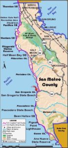
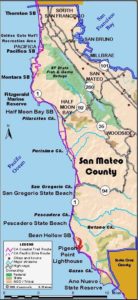
This stretch of the San Mateo coast has the potential for some excellent coastal hiking, but unfortunately for now, nearly all the 10¼-mile walk follows roads. The good news is that it's mostly through scenic rolling agricultural land.
Eventually the Coastside Trail will extend farther south where impassable rocky tidelands will keep the trail on the bluffs. The two golf courses just south of Redondo Beach Road now have new a link in the Coastal Trail, but the CCT there has not yet been connected with the CCT north or south, essential for that path to truly become a link in the Coastal Trail. When the trail is done, it will connect the beach ending at Miramontes Point beyond Redondo Beach Road to the Cowell Ranch land purchased in 1996 by the Coastal Conservancy. This will add 2½ miles to the trail, eliminating some highway walking.
In the meantime, CCT follows Redondo Beach Road east to the highway at ¾ mile. Turn south and walk the highway shoulder. At the traffic light for Miramontes Point Road beyond 1⅜ miles, one can turn right and go ⅜ mile to walk the new ¾-mile link in the Coastal Trail, which leads north and south for about ⅜ mile from the parking lot. (It hasn't yet been connected to the main CCT. Watch for flying golf balls and speeding golf carts if you go.) For now, CCT continues along the highway shoulder to Verde Road at 3¼ miles. The Cowell Ranch trail will end here when done. Turn left and follow Verde Road as it heads inland to 3½ miles then turns south. This quiet rural road provides relief from walking the busy highway. The road veers inland briefly to cross Lobitos Creek, passing a few houses in the tiny historic settlement of Lobitos, eucalyptus groves, and a pumpkin farm before returning to the highway at 5½ miles.
As you follow the highway south, you can only wish CCT took you across the coastal bluffs now privately owned and down to some of the pristine beaches hiding below the bluffs. At 5¾ miles Martin's Beach Road leads down to the beach. Open year round, a parking fee is charged. The little store only opens in summer. At 7¼ miles you pass Tunitas Creek where private property blocks access to the inviting beach. You overlook the beach and cliffs as you walk south along the highway up a hill. At the top of the long grade around 9¼ miles, Stage Road heads east. Take this road to avoid a long highway descent. Stage Road soon swings south and snakes down the hill. At the historic little village of San Gregorio at the bottom, stop in at the general store for almost anything you want, from sunscreen to a glass of wine. After you visit the store, walk La Honda Road west ¾ mile down to Highway 1. Take extreme care crossing the highway to San Gregorio Beach since the traffic goes very fast. This section ends here at 10¼ miles.
SUGGESTED ROUND TRIP & LOOPS: You can drive to the new parking lot on Miramontes Point Road and walk the new, still disconnected link in the Coastal Trail through the golf courses of the otherwise gated Spyglass and Ocean Colony subdivisions. It leads north and south with ocean views for about ⅜ mile each, meaning a 1½mile round trip if you do it all.
Distance: 10¼ miles (16.5 kilometers).
Open to: Hikers, bicyclists.
Surface: Highway shoulder, road shoulder.
Access point: Redondo Beach Road.
How to get there: Turn west off Highway 1.5 miles south of Half Moon Bay on Redondo Beach Road. Go .75 mile and park at the end of the road.
Other access:
Difficulty: Easy
Elevation gain/loss: 490 feet+/450 feet-.
Cautions: Beware of speeding traffic when walking Highway 1.
Further information: San Mateo Coast State Beaches (650)879-2170.
Facilities: Store in San Gregorio. Chemical toilets at San Gregorio Beach.
Campgrounds: Francis Beach Campground at Half Moon Bay State Beach on previous section. Pelican Point RV Park (650)726-9100 on this section.
Lodging: Pigeon Point Lighthouse Hostel (650) 879-0633 at end of Section 8. Half Moon Bay area has several motels.
Interested in contributing to this project?
Register to add new photos and information, update existing results and share your trip reports.


