
Usage Notes

Legend: For details on the icons and trail colors, please click the legend icon on the map above.

Layers: Other layers are available. See the California Coastal Commission and Coastal Conservancy Completed Sections layer for the official completed trail segments. (About progress on the trail completion project.)
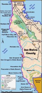
San Mateo Section 5
Pillar Point Harbor to Redondo Beach Road, Half Moon Bay
In sharp contrast to the last two sections, this section offers an easy, flat walk which follows the beach and bluff forming the gentle curve of Half Moon Bay. The route is really two parallel paths: one on the beach and the other on the paved Coastside Trail on the low bluff above. If the tide iS in and blocking the way, simply walk on the multi-use Coastside Trail.
Start the walk at the harbor and walk southeast along the waterfront, passing the pier and boat ramp and an RV park before reaching the east breakwater at ½ mile. Surfers use the beach here because of the shore break created by the breakwater. The bluff has been eroding at a fast rate since the harbor breakwater was built in 1959. See the feature article.
Continue south along the beach or on the bluff. El Granada Beach was once a popular vacation destination for San Franciscans who rode the Ocean Shore Railroad here in the early 1900s. Around 1½ miles you reach Miramar Beach. The odd, driftwood looking A-frame building peering over the low bluff is the Miramar Beach Health Club.
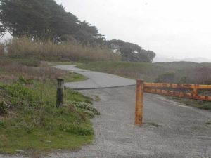
At 2¼ miles the Sweetwood Group Camp is sheltered behind a row of Monterey pines on the bluff. You'll find an outhouse and water at the camp. The Coastside Trail goes through the middle of the camp. If Frenchman's Creek, and Pilarcitos Creek a little farther along the beach, are flowing heavily into the surf, the paved trail has bridges over the creeks. Pass Francis Beach Campground, then the headquarters for Half Moon Bay State Beach at the end of Kelly Avenue at 3½ miles. The old downtown section of Half Moon Bay can be found ¾ mile inland on Kelly. You can continue down the beach or the Coastside Trail. Beyond Poplar Avenue around 4½ miles, the Coastside Trail hasn't yet been completed, but a broad dirt path continues south for another 1¾ miles. As you walk south the bluffs get higher, reaching over 40 feet high at Miramontes Point. Around 5¼ miles just before Redondo Beach Road, walk up a ravine to find the dead end of the dirt Redondo Beach Road at 5½ miles where this section ends. There are no services here. Highway 1 is ¾ mile inland.
SUGGESTED ROUND TRIP & LOOPS: You can reach this walk from several State Park parking lots and public streets along the route presenting numerous possibilities for short or long round trip beach strolls.
Distance: 5½ miles (8.9 kilometers).
Open to: Hikers, bicyclists. Equestrians on part of the beach.
Surface: Beach, paved trail.
Access point: Pillar Point Harbor.
How to get there: Turn west off Highway at the well marked exit to Pillar Point Harbor and Princeton, 2.5 miles south of Moss Beach and 4 miles north of Half Moon Bay. Take Capistrano Road to the harbor parking lot.
Other access: Parking lots along this route at the ends of Young Avenue, Venice Avenue, Kelly Avenue and Poplar Avenue.
Difficulty: Easy
Elevation gain/loss: 50 feet+/50 feet- (depending how often you climb the bluff).
Cautions: The trail exiting the beach at Redondo Beach Road is steep and undeveloped.
Further information: Half Moon Bay State Beach (650)726-8819.
Facilities: Store, restrooms, water at Pillar Point Harbor. Toilets and water at several locations along the route, but not at the end.
Campgrounds: Francis Beach Campground at Half Moon Bay State Beach. Group Camp at Sweetwood.
Lodging: Montara Lighthouse Hostel on previous section (650)728-7177. Half Moon Bay has several motels.
Points of Interest

In the News
Interested in contributing to this project?
Register to add new photos and information, update existing results and share your trip reports.