
Usage Notes

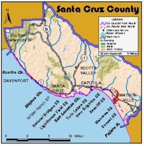
Legend: For details on the icons and trail colors, please click the legend icon on the map above.

Layers: Other layers are available. See the California Coastal Commission and Coastal Conservancy Completed Sections layer for the official completed trail segments. (About progress on the trail completion project.)
Santa Cruz Section 5
Santa Cruz Wharf to Capitola
This pleasant urban walk leads from one interesting beach town to another, both with wharves and tourist attractions. The Coastal Trail here will likely remain mostly on residential streets far into the future since most of the bluffs are developed, and negotiating the rocky tideline is impossible in places.
From the wharf you can either walk down to the beach and follow the tideline or walk along the street and through the Boardwalk amusement park, one of the oldest in California. For a thrill, catch a ride on the 1924-vintage wooden roller coaster. Both routes bring you to the San Lorenzo River at ⅝ mile. If you're on the beach, walk a block up river to the old railroad bridge. Cross the railroad bridge on the pedestrian walkway on the inland side and turn right on East Cliff Drive. Follow the sidewalk a short block, then follow the street as it turns left overlooking the beach. A short side trip is the walk out to San Lorenzo Point, the rock spit jutting into the surf on your right. Continue down the coast along East Cliff to one mile. At the sign "SEABRIGHT BEACH," walk out along the beach.
At 1⅜ miles you reach the mouth of the Santa Cruz Small Craft Harbor where you can walk out on the jetty if the surf is quiet. The Coastal Trail heads inland on the path along the harbor. Walk the sidewalk through the harbor parking area and climb the steps to the bridge at 1½ miles. Turn right and cross the bridge over the harbor, and alter a few hundred feet, turn west and drop down into another parking lot. Skirt the harbor with its thicket of sailboat masts and come to a row of shops and a restaurant just up from the beach at 1⅞ miles. You might visit the interpretive display in front of the Crows Nest Restaurant for information about the Monterey Bay National Marine Sanctuary.
Walk down to the beach and turn left, walking the tideline of Twin Lakes State Beach past the mouth of Schwan Lake. Before you come to impassable Black Point, turn left on a dirt trail between cypress trees that heads inland to 14th Avenue.
From here to Capitola, the trail follows city streets because years ago the bluffs were intensely developed with housing subdivisions with little respect for public access or views. Walk 14th to East Cliff Drive and turn right, then follow East Cliff as it jogs right for one block, then turns left to stay within sight of the ocean. Pass a couple of short side trails to the beach and walk the shoulder of East Cliff around Soquel Point to Pleasure Point at 4⅛ miles. You pass several overlooks and access to rocky beaches along this blufftop road. Pleasure Point has some benches overlooking this popular surfing spot.
Continue along East Cliff Drive to 41st Avenue, then veer right onto Opal Cliff Drive at 4¾ miles. The homes here block your ocean views along this stretch. For a side trip look for a gap between the houses marked by a chain link fence and a sign. It leads to an ocean view and access to several pocket beaches. At about 5⅜ miles the houses end and the road follows the edge of a steep eroding cliff overlooking a rocky a beach and the Capitola Wharf. One wonders how long the houses built on the bluff edge can last after looking at the street breaking off into the surf here.
At 5⅝ miles you arrive at the bridge crossing the shallow estuary of Soquel Creek. A restored and oddly designed old motel of Italian motif faces the estuary. Take Wharf Road one block to the Capitola Wharf. Just over the bridge turn onto Esplanade, passing bars, restaurants, and shops before coming to City Beach and section's end at 5¾ miles. This popular beach has benches and restrooms.
SUGGESTED ROUND TRIPS & LOOPS: From the Santa Cruz Wharf, walk north over Beach Hill to overlook historic downtown Santa Cruz. It's less than a mile to the heart of town. Downtown Capitola fronting the beach is full of restaurants and shops.
Distance: 5¾ miles (9.3 kilometers).
Open to: Hikers. Bicyclists on most.
Surface: Beach, sidewalk.
Access point: Santa Cruz Wharf.
How to get there: Turn east off Highway west of downtown Santa Cruz onto Laurel Street. Go downhill and across the railroad tracks, then turn right on Washington Street and follow it to the Wharf at its end.
Other access: The entire route is accessible by city streets.
Difficulty: Easy
Elevation gain/loss: 60 feet+/70 feet-.
Cautions: Watch for traffic.
Further information: Santa Cruz County Department of Parks and Recreation (831)454-7900.
Facilities: Restrooms, water, picnic tables at wharf, Capitola and several places on route.
Campgrounds: Henry Cowell Redwoods State Park 3 miles inland has camping.
Lodging: Santa Cruz Hostel (831)423-8304. Abundant lodging in area.
Points of Interest
No individual points found.
In the News
Interested in contributing to this project?
Register to add new photos and information, update existing results and share your trip reports.