Usage Notes

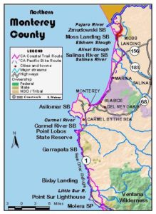
Legend: For details on the icons and trail colors, please click the legend icon on the map above.

Layers: Other layers are available. See the California Coastal Commission and Coastal Conservancy Completed Sections layer for the official completed trail segments. (About progress on the trail completion project.)
Santa Cruz Section 7
Manresa State Beach to Pajaro River
The last walk in Santa Cruz County follows a tranquil stretch of the California coast. This gentle, remote area contrasts vividly with the hills, high bluffs and cliffs of the north county and the urban landscape of Santa Cruz.
From the Manresa State Beach stairway simply head south on the wide beach at the base of low bluffs. You have miles of sand, crashing waves, shells, solitude and peace. The Monterey Bay National Marine Sanctuary offshore teems with birds, sea mammals and fish.
At 2¾ miles you arrive at the access path from the Sunset State Beach parking lot. Up the path you'll find the park headquarters, campground, picnic tables and water. From here to the mouth of the river, the bluffs give way to the largest dunes system in the county. The dunes rise steeply off the beach, and the campground is on the sheltered east side of the dunes.
Continue down the beach on this sandy stroll. You reach the Palm Beach Access of Sunset State Beach beyond 5 miles, the southernmost vehicle access for this section. It's located at the north end of the Pajaro Dunes condominium development built right on the dunes. The development seems ill advised since it not only sits on dunes but also at the mouth of a river.
To finish this section, walk the beach down to the mouth of the Pajaro River around one mile. If you are not continuing into Monterey County, return the way you came. If you want to continue south, in summer you can usually wade the river and continue down the beach to the Zmudowski State Beach parking lot and section's end at 7¼ miles. The lot lies inland from the beach behind the low dunes. When the river is too deep to ford, follow the Alternate Route.
ALTERNATE ROUTE: If you can't ford the Pajaro River, from the Palm Beach access, follow Beach Road northeast. Then turn right and go south on Thurwachter Road. After crossing the river it continues as McGowan Road. Turn right and follow Trafton Road, then go left on Bluff Road, then left on Jensen Road to Highway 1. Follow the highway shoulder about 1½/ miles south. Turn right and walk Struve Road to Giberson Road, then go right on Giberson to its end.
SUGGESTED ROUND TRIPS & LOOPS: From Manresa, Sunset, or Palm Beach you can have a fine sandy day hike as long as you'd like.
Distance: 7¼ miles (11.7 kilometers).
Open to: Hikers.
Surface: Beach.
Access point: Manresa State Beach.
How to get there: Take the San Andreas Road exit from Highway - south of Aptos. Head southwest to beach parking around 2 miles.
Other access: Sunset Beach Road leads to the Sunset State Beach Access. Beach Road ends at the Palm Beach access. Continue south on San Andreas Road to intersect these roads. South end access: End of Beach Road.
Difficulty: Easy
Elevation gain/loss:
Cautions: Stay off private property east of the beach.
Further information: Santa Cruz District State Parks (831)429-2850, Manresa State Beach (831)724-3750.
Facilities: Restrooms, water at Manresa State Beach (at top of stairs), Sunset State Beach entrance station and at Palm Beach.
Campgrounds: Sunset State Beach has camping.
Lodging: Aptos and Watsonville have several choices.
Points of Interest
In the News
Interested in contributing to this project?
Register to add new photos and information, update existing results and share your trip reports.


