
Usage Notes

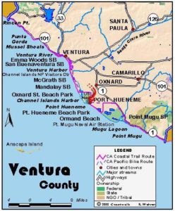
Legend: For details on the icons and trail colors, please click the legend icon on the map above.

Layers: Other layers are available. See the California Coastal Commission and Coastal Conservancy Completed Sections layer for the official completed trail segments. (About progress on the trail completion project.)
Ventura Section 3
Ventura City Pier to McGrath State Beach
This section offers a fine beach walk interrupted by the man-made Ventura Harbor carved out of dunes. Consider visiting the Channel Islands National Park Visitor Center perched on the south shore at the harbor mouth or checking out the good birding at the mouth of the Santa Clara River at McGrath State Beach.
After strolling on the 1700-foot long Ventura Pier for a boat captain's view of the Ventura beachfront, walk down the wide sandy beach past the huge picnic area and parking lot of San Buenaventura State Beach before one mile. Continuing down the beach, in the second mile you pass houses covering what was once a dune environment.
You reach Marina Park nestled in sand dunes on the north peninsula of Ventura Harbor at 2 miles. The only way to avoid walking residential streets around the large harbor is to arrange a boat ride from Marina Park over to the Channel Islands National Park Visitor Center. Unless you take a boat, turn into Marina Park at a large masted playground boat and walk east. Walk along the shore of the harbor briefly before turning north through the parking lot to follow Pierpont Blvd. for about ⅜ mile. From Peninsula Street you make your way on residential streets to get around the harbor.
From Pierpont Blvd. turn right on Peninsula Street, then right on Seahorse Avenue at 2⅞ miles. Go left on Oyster Street at 3⅛ miles, then right on Seaview Avenue to its end, where you turn right on Beachmont Street. Where Beachmont Street swings south it becomes Anchors Way Drive. At this point you can walk west out to the Ventura Port headquarters and along the waterfront in front of a hotel for about ¼ mile. Walk either on the sidewalk or along the sport fishing docks, but then you must return to Anchors Way Drive and continue to its end. Go left on Navigator Drive to the southeast corner of the harbor, then turn right on Spinnaker Drive where boat slips and dockside businesses abound. Make your way along the waterfront on a walkway, with some detours around buildings.
After Spinnaker Drive turns north around 6 miles, you have a choice of routes. You can cut over to the beach past the sign for Ventura Harbor Village, or walk north to the end of Spinnaker and the Channel Islands National Park Visitor Center to find out about the islands and how to get a boat ride out to them. The nearest, Anacapa Island, lies 10 miles offshore while Santa Barbara Island lies 45 miles offshore.
From the Visitor Center, walk across the street to the beach and follow the tideline south. Around 7½ miles (6¾ miles if you took the shortcut), you cross the mouth of the Santa Clara River, usually crossable except during heavy rainfall or higher tides. The 160-acre Santa Clara River Estuary Natural Preserve protects the thickly vegetated estuary. At 7¾ miles the CCT continues down the beach on Ventura Section 4 and this section ends. To get to McGrath State Beach Campground, turn inland across a wide beach, then follow one of the numerous unmarked volunteer paths through the dunes to the large campground at 8¼ miles.
SUGGESTED ROUND TRIPS AND LOOPS: Walking south from the Ventura City Pier or north from McGrath Beach to the harbor mouth offers two fine round trip strolls of about 4 miles each.
McGrath Beach State Park has a short nature trail exploring the Santa Clara Estuary Natural Preserve, starting near the entrance station.
Check with the National Park Service-licensed Island Packers next to the Visitor Center about booking a trip out to the Channel Islands. Great hiking, camping and diving opportunities abound on the islands. Call (805)642-7688 for information.
Distance: 7¾ miles (add ½ mile to McGrath Campground) (12.5 + 8 kilometers).
Open to: Hikers. Bicyclists on bike path.
Surface: Beach, bike path, sidewalk.
Access point: Ventura City Pier.
How to get there: Take the Downtown Ventura exit off of Highway 101. The pier is adjacent to downtown Ventura near the end of California Street at Harbor Blvd.
Other access: San Buenaventura State Beach, and anywhere on the harbor part of the route.
Difficulty: Easy
Elevation gain/loss: None.
Cautions: None.
Further information: San Buenaventura State Beach (805)654-46 10, Ventura City Department of Parks and Recreation (805)652-4594, McGrath State Beach (805)654-4744, Channel Islands National Park (805)658-5700.
Facilities: City amenities at Ventura City Pier and around the Ventura Harbor. Marina Park and the Channel Islands Visitor Center have restrooms, picnic tables and water. McGrath State Beach has water, picnic tables and restrooms.
Campgrounds: McGrath State Beach has 174 sites and hot showers.
Lodging: The Ventura area has abundant accommodations including the moderate Vagabond Inn and the deluxe Holiday Inn right near the pier.

Interested in contributing to this project?
Register to add new photos and information, update existing results and share your trip reports.