
Usage Notes

Legend: For details on the icons and trail colors, please click the legend icon on the map above.

Layers: Other layers are available. See the California Coastal Commission and Coastal Conservancy Completed Sections layer for the official completed trail segments. (About progress on the trail completion project.)
Ventura Section 4
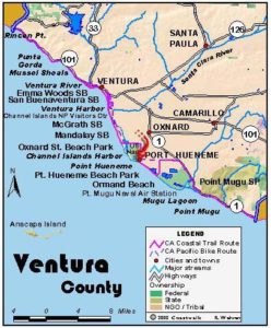
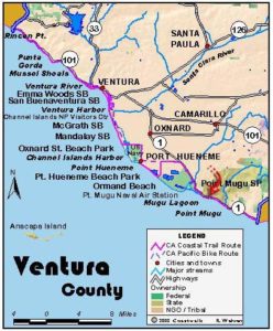
McGrath State Beach to Port Hueneme Beach Park
This CCT section in the middle of the Ventura Coast starts out on the wide, long pleasant strand of McGrath State Beach, one of those lesser known spots in southern California where you can get away from it all in a natural setting. Then it passes several expansive, grassy parks, detours inland around not one, but two man-made harbors and a Navy base, and returns to the beach at Port Hueneme.
Day hikers need to cross the dunes from McGrath State Beach Campground to reach the Coastal Trail where it runs along the beach, about ½ mile. Follow the tideline of the sandy beach south with low vegetation-stabilized dunes above the beach. From ¾ mile, freshwater McGrath Lake lies hidden in the dunes. By one mile you might walk up to the top of the beach and follow the lake's shore to 1¼ miles. Return to the tideline and continue south. By 1⅝ miles the Mandalay Power Plant rises in the dunes on your left. You pass its water outlet jetty on the beach.
At 2 miles you reach Mandalay County Park, with 104 acres of beach and vegetated dunes, a pleasant natural habitat. The dunes reach their broadest point here, extending inland about ⅝ mile. Beyond the park around 2⅜ miles, the Oxnard Shores subdivision begins. It lies up from the beach until around 3¼ miles. The CCT continues along the beach.
At 3½ miles you come to Oxnard State Beach where low dunes once again lie up from the awesomely broad beach. Behind the dunes lies a large expanse of grass with picnic areas, athletic fields and restrooms. Continue along the beach past the main park area and a hotel until you see tall palm trees at 3¾ miles. Turn inland through a small park there to begin the walk around the harbors and the Navy base.
Walk diagonally through the park a few hundred feet to pick up a bike path at the corner of Mandalay Beach Road and Sunset Lane. The path comes out at the corner of Harbor Blvd. and Channel Islands Blvd. at 4 miles. Cross Harbor Blvd. and follow the south side of Channel Islands Blvd., crossing two bridges over the upper end of Channel Islands Harbor. On the other side, find a faux fishing village full of the usual collection of tourist shops plus a hidden jewel, the Ventura County Maritime Museum with its excellent collection of model boats.
The rest of the route follows bike lanes or sidewalks. Walk Channel Islands Blvd. on either the sidewalk on the left side or the bike lane on the right. Turn right at Ventura Road at 6 miles and follow the paved path beneath eucalyptus trees on the right side of Ventura Road that runs along the edge of the Navy base. Your route changes to sidewalk at Pleasant Valley Road at 7¾ miles and the beginning of the Port Hueneme business district. Continue along Ventura Road to its end at the Port Hueneme Beach Park at 8½ miles where you will find restrooms, picnic tables, and a fishing pier. This section and the town walk also end here.
SUGGESTED ROUND TRIPS AND LOOPS: Starting from either McGrath State Beach or Oxnard State Beach, walk out and back for an exceptional 7-mile beach stroll. You might also consider a visit to Hollywood Beach or Silver Strand Beach, two long sandy strands bypassed by the CCT.
Hollywood Beach lies just south of Oxnard State Beach. To reach Silver Strand, go south on Victoria Avenue (just east of the Maritime Museum) to its end at Ocean Avenue where the beach spans the entire oceanfront between the two harbors.
Distance: 8½ miles (13.7 kilometers).
Open to: Hikers. Bicyclists on road.
Surface: Beach, sidewalk.
Access point: McGrath State Beach.
How to get there: Exit Highway 101 in Ventura onto Victoria Avenue and go south to Olivas Park Drive. Turn right and drive west to Harbor Blvd., then turn left and go about one mile to the McGrath State Beach Campground entrance.
Other access: Mandalay County Park via 5th Street, various points along Mandalay Beach Road including Oxnard State Beach, anywhere along route on Channel Islands Blvd. and Ventura Road, Port Hueneme Beach Park.
Difficulty: Easy
Elevation gain/loss: Negligible.
Cautions: McGrath State Beach (805)654-4744, Oxnard Department of Parks and Facilities (805)385-7950, Port Hueneme Recreation and Community Services (805)986-6555.
Further information: None.
Facilities: Restrooms, water, picnic tables at McGrath State Beach, Mandalay County Park, Oxnard State Beach and Port Hueneme Beach Park.
Campgrounds: McGrath State Beach has the largest campground on the Ventura coast with 174 sites and hot showers.
Lodging: Oxnard and Port Hueneme have abundant accommodations.

Interested in contributing to this project?
Register to add new photos and information, update existing results and share your trip reports.