
Usage Notes

Legend: For details on the icons and trail colors, please click the legend icon on the map above.

Layers: Other layers are available. See the California Coastal Commission and Coastal Conservancy Completed Sections layer for the official completed trail segments. (About progress on the trail completion project.)
Del Norte Section 2
Yontocket, Tolowa Dunes State Park, to Kellogg Beach
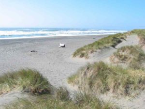
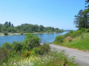
This hike explores an extensive system of ancient dunes deposited by the Smith River as it carved the Siskiyou Mountains. The vegetated dune complex has evolved into many different ecological communities supporting a vast array of plants and animals, with 250 bird species alone. Lake Earl and Lake Talawa, freshwater lagoons totaling more than 2000 acres, support: striking diversity of fish and aquatic vegetation. You'll find all this and more within the 10,000 acres of Tolowa Dunes State Park and Lake Earl Wildlife Area where up to half the acreage may be covered with water in the wet season. If you camp here in late spring/ early summer, be prepared for the thriving mosquito population.
The native Tolowa people, who have lived in this area for at least 2300 years, consider the vegetated dunes around Yontocket to be the center of the world, the place where the First People created our world.
From Yontocket Trailhead, walk west on the gravel road behind the white gate for almost ½ mile to an intersection. The grassy double track running northsouth is CCT. (To reach the Smith River mouth, turn right and head north between dunes for less than ¼ mile to another junction, then go left on the path west through the dunes, coming to the beach at 1⅛ miles. Turn right and walk the beach about 2 miles to the river mouth.) Turn left on CCT and climb the short hill to the Yontocket Cemetery where a picnic table sits beside a trail junction. (The left fork leads ⅝ mile a to a hike/bike/ horse camp.) Take the right fork and descend into a grassy valley, then climb over a wooded ridge into another grassy swale. Ascend along a mossy slope, then follow a ridgetop where Sitka spruce grow.
At ½ mile from Yontocket your gravel road dips into a valley where common juniper grow between wooded dune ridges. Follow the valley to a junction at ⅞ mile where a side trail on the right heads through dune and marsh to reach the beach in ½ mile. CCT continues south past a trail on the left, ascending gently along the crest of a dune offering views of the coast to the west and a large pond a to the east. Leave the dune crest at 1⅛ miles to drop through the dunes and over another sandy ridge.
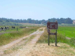
Around 1⅜ miles as the gravel track veers left (it leads to Environmental Camps), the Coastal Trail veers right onto a grassy double track that descends a south into a wooded valley. Climb through the forest to top a sandy ridge, then drop through grasslands with clumps of elderberry and huckleberry around 1⅝ miles. Contour past a stand of wind-shaped shore pines, then dip through a low area around 2 miles that may be wet in winter and spring. Continue through the grasslands, passing windswept dunes on your left around 2⅜ miles. Soon two side trails fork left toward the nearby camps. CCT stays on the double track until the parking area at 2⅝ miles.
CCT follows the parking loop to its end at Kellogg Road at 2¾ miles. Turn right and follow CCT west along the pavement to the end of Kellogg Road at 3⅜ miles where the beach stretches for miles up and down the coast. Del Norte Section 3 is on the left. The Alternate Route, which ends here, is on the right.
ALTERNATE ROUTE: If you prefer beach walking to exploring the mysterious vegetated dunes to the east, one long beach stretches from the south side of the Smith River mouth all the way to the end of Kellogg Road at 5¼ miles. In fact it might be easy to miss Kellogg Road since the beach continues all the way to Point St. George, a total distance of 10½ miles with a possible winter breach of the barrier beach at the mouth of Lake Talawa.
SUGGESTED ROUND TRIPS & LOOPS: If you're day hiking, you can loop back to Yontocket by several routes. Any of the trails east of CCT will lead to the network of trails in the eastern edge of the vegetated dunes where several seasonal ponds offer surprises. By heading north along the beach, you can turn east on either of two trails. The first, 1½ miles north of the end of Kellogg Road, may be wet in winter and spring. The second at 3 miles leads through the dunes, returning to CCT north of Yontocket.
Distance: 3⅜ miles (5.4 kilometers).
Open to: Hikers, equestrians. Dirt roads south of Yontocket open to mountain bikes.
Surface: Dirt roads, paved road.
Access point: Yontocket Trailhead.
How to get there: Turn west off Highway 101 onto Elk Valley Cross Road .6 mile north of the Highway 199 interchange north of Crescent City. Turn right on Lake Earl Drive in .9 mile. At 2.9 miles from Highway 101, turn left on Lower Lake Road and drive to its end, then go left on Pala Road for one mile to the trailhead at a white gate.
Other access:
Difficulty: Easy
Elevation gain/loss: 200 feet+/180 feet-.
Cautions: Portions of trail may be wet in winter and spring.
Further information: Tolowa Dunes State Park 464-6101, ext. 5151, Lake Earl Wildlife Area (707)464-2523.
Facilities: None at access point. Yontocket has a picnic table. Near Kellogg Road Trailhead are Environmental Camps with tables and chemical toilets.
Campgrounds: Six pleasant Environmental (walk-in) Camps are located just east of Kellogg Road Trailhead. You must call first (ext. 5151).A Hike/Bike/Horse Camp ⅝ mile south of Yontocket has tables, toilets, non-potable water, a fireplace and corral. Car camping available at Jedediah Smith Redwoods State Park east of Highway 101.
Lodging: Many motels in Crescent City.
Interested in contributing to this project?
Register to add new photos and information, update existing results and share your trip reports.