
Usage Notes

Legend: For details on the icons and trail colors, please click the legend icon on the map above.

Layers: Other layers are available. See the California Coastal Commission and Coastal Conservancy Completed Sections layer for the official completed trail segments. (About progress on the trail completion project.)
Del Norte Section 1
Oregon-California Border to Yontocket, Tolowa Dunes State Park
Welcome to the Oregon-California border, beginning and end of the California Coastal Trail. If you're from south of here, this may seem like a vast wilderness. If you're from the north, you're probably wondering where all the cars on the highway came from. The truth lies somewhere in between.
Symbolically this section of CCT is a great beginning. Just 500 feet from a busy U.S. highway, you can look south even on a clear day and feel as if you are in a wilderness, except for a few nearby houses. The broad beach arches south to the triple cones of Hunter Rock and Prince Island offshore and Pyramid Point along your route.
What you cannot see lurking just beyond the point is the forceful mouth of the Smith River, California's largest undammed river and one of its finest. Where CCT meets the river, you can only Cross the river with a boat. Without a boat you have two choices: retrace your steps for a pleasant day hike, or detour 13 miles on road shoulders to cross the river on the highway bridge and reach CCT south of the river. If you choose the detour, you'll find it described at the end of this section.
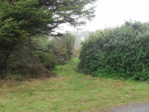
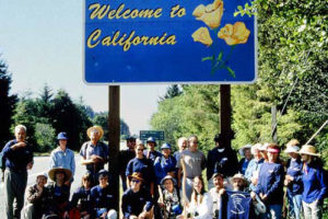
The California Coastal Trail actually begins 50 feet north of the "WELCOME TO CALIFORNIA" sign where a path heads through alder/spruce forest onto the broad sandy beach. Walk about 900 feet to the tideline where you'll have to visualize your own Oregon-California border in the sand. Turn south and follow the firm sand along the high tideline.
Pass through undeveloped Pelican State Beach around ½ mile where a road to the east leads to Highway 101. Continue down the beach as it veers southeast, drawing near the highway briefly, then turn south to ford Gilbert Creek at 1⅜ miles.
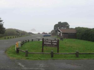
Beyond the ford the beach straightens out, passing through Kamph Memorial County Park at 2 miles where Cone Rock lies offshore. A phone, tiny campground, picnic tables and restrooms stand atop the bluff to the east. CCT leaves the tiny park, continuing south along the tideline.
By 2⅜ miles the beach narrows and becomes steeper. After the ford of Lopez Creek around 2⅞ miles, the beach narrows again. You pass the twin cones of Hunter Rock offshore. Follow the beach out to a rocky point at 3⅜ miles, then continue south with Prince Island offshore. As you pass the island, the beach swings southeast toward Pyramid Point past many offshore rocks.
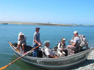
When you reach Pyramid Point at 3¾ miles, turn east just before the sandy beach ends, climbing along the west face of a rock outcrop and crossing the bluff on a grassy trail around the ocean side of a private residence to overlook the mouth of the river. Before 3⅞ miles a rough trail descends to the pebble beach of Smith River County Park, a good turnaround point for day hikers not planning to cross the river. If you have a boat lined up for the crossing, follow the north bank of the river east and southeast to Xaa-wan’-k’wvt Village & Resort then to the boat dock at 4⅜ miles. If you can't arrange a boat, see Alternate Route A.
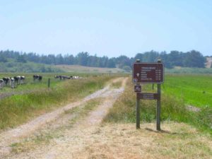
You want the boat to drop you on the sand spit just south of the river mouth. Walk to the west side of the spit and follow the Pacific shore south about 1½ miles, 5⅞ miles from the border if the boat dropped you near the river mouth. Look east toward the dunes for a bright orange triangle. It marks the CCT route south where it enters the dunes of Tolowa Dunes State Park. Walk to the triangle and take the path into the dunes (Alternate Route B stays on the beach). Follow the sandy path east and south. Stay to the right at a trail junction (the left fork heads to the Smith River). Follow the path into dunes of increasing size. By 7 miles : high, wooded dune is to your west, and your trail has become a double track. Continue south to the junction where the double track from Pala Road enters from the left. Turn right and walk uphill past old apple trees. At 7½ miles you reach the top of the hill, site of the Tolowa village Yontocket where a Tolowa cemetery is on your left.
ALTERNATE ROUTES: If you haven't arranged a boat shuttle across the Smith River, you need to take CCT Alternate Route A which follows roads on this 13-mile detour. Head northeast to Highway 101, then cautiously cross the highway and walk the shoulder of Ocean View Drive southeast to Sarina Road. Cross the highway and take Sarina Road south ½ mile, then turn east and follow First Street into the town of Smith River. When First Street ends at Fred Haight Drive, take the latter south until It returns to Highway 101. Follow the highway south across the river, then turn right onto Lake Earl Drive. Go west to Bailey Road, turn right and head north briefly, then head west on Moseley Road to its end. Turn right and follow Lower Lake Road north to Pala Road, then follow Pala Road west to the gate at Tolowa Dunes State Park boundary. From there it is ½ mile to Yontocket, about 3 miles north to the Smith River mouth. Alternate Route B stays on the beach south of the Smith River all the way along the western edge of Tolowa Dunes State Park. It meets the end of Kellogg Road about 5 miles from the mouth of Smith River.
SUGGESTED ROUND TRIPS & LOOPS: The 3¾ miles of beach between the border and Pyramid Point offer a pleasant walk. From Yontocket north to the river mouth offers another pleasant 3 miles, especially the 1⅝ miles through the dunes.
Distance: 7½ miles or 17⅜ miles with detour to cross Smith River (12.1 or 28 kilometers).
Open to: Hikers, equestrians.
Surface: Beach, trail.
Access point: "WELCOME TO CALIFORNIA" sign at Oregon-California border.
How to get there: Drive Highway 101 to the Oregon-California border, 21 miles north of Crescent City, 7 miles south of Brookings, Oregon.
Other access: Pelican State Beach, Kamph Memorial Park, Smith River County Park, and Xaa-wan’-k’wvt Village & Resort.
Difficulty: Easy
Elevation gain/loss: 120 feet+/80 feet-.
Cautions: You must hire a boat to cross the Smith River. Contact Xaa-wan’-k’wvt Village & Resort(707) 487-3341. Otherwise a 13-mile detour along roads is required.
Further information: Pelican State Beach, To Iowa Dunes State Park (707) 464-6101, ext. 5151, Del Norte County Parks: (707) 464-7230.
Facilities: None at access point. Phone .3 miles south at California State Inspection Station.Restrooms, water, phone, and picnic area at Kamph Memorial Park. Picnic area at Yontocket.
Campgrounds: Kamph Memorial Park has a small camping area. Xaa-wan’-k’wvt Village & Resort has lodging, and future tent camping at a private campground. Ruby Van Deventer County Park and Jedediah Smith State Park, a few miles upriver, and Harris Beach State Park north of Brookings also have camping. A walk-in campground is 5/8 mile south of Yontocket.
Lodging: Pelican Beach Motel and Xaa-wan’-k’wvt Village & Resort are on the route. More lodgings are in Smith River and Crescent City to the south or Brookings to the north.
Points of Interest
In the News
Interested in contributing to this project?
Register to add new photos and information, update existing results and share your trip reports.