
Usage Notes

Legend: For details on the icons and trail colors, please click the legend icon on the map above.

Layers: Other layers are available. See the California Coastal Commission and Coastal Conservancy Completed Sections layer for the official completed trail segments. (About progress on the trail completion project.)
Del Norte Section 3
Kellogg Beach to Point St. George
Nearly 12 miles of continuous beach form the shore of Pelican Bay from the Smith River mouth on the north to Point St. George on the south. Kellogg Road provides hikers access to the middle of this long, gently curving strand. Kellogg Road also allows off-road vehicles to reach the beach, but most of the year you won't see many ORVs on this CCT section. They prefer to drive north toward the Smith River. A more pressing worry is whether the Lake Talawa surge channel 3 miles down the beach is flowing when you visit. If it is, you will not be able to cross it, so you might call ahead to find out.
From the end of Kellogg Road, walk the long, virtually straight beach south southwest. Your hike parallels a line of sand dunes along the top of the beach. On the clearest days, you'll see the often snow clad high peaks of the Siskiyou Mountains to the east. As you walk the tideline along this southern end of Pelican Bay, watch the surf for sneaker waves.
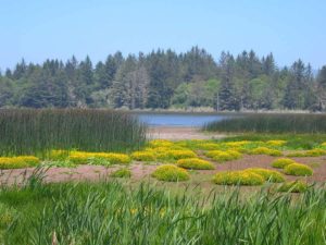
By 2½ miles the dunes east of the beach become lower, perhaps allowing a look at nearby Lake Talawa and Lake Earl to the east. You soon may notice several paths leading into the nearby Pacific Shores Subdivision, a maze of roads where development was halted by the Coastal Commission.
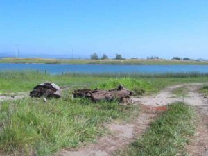
Around 3 miles you reach the low channel at the mouth of Lake Talawa which provides a seasonal outlet and more often a high-tide inlet for the brackish lake. If the surge channel has opened up allowing the lake to empty into the Pacific, you will need to turn back and take the Alternate Route.
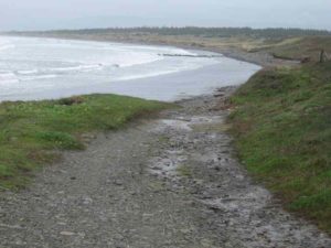
Assuming you can cross the barrier beach at Lake Talawa's mouth, continue south along the tideline, soon entering Tolowa Dunes State Park. Several trails from Old Mill and Sand Hill roads end at the beach between 3¾ and 4⅝ miles, the last of which is the trail from Dead Lake. Just beyond Dead Lake Trail you come to a ford of Sweetwater Creek, an easy crossing except in winter. Continue along the sandy shoreline, crossing another seasonal creek around 5⅝ miles. After the creek, the beach narrows as Point St. George rises ahead. You are soon walking a narrow beach at the base of vegetation-covered sandstone bluffs. Round the northern tip of Point St. George at 6¼ miles, promptly meeting a broad rocky path by which CCT ascends onto the grassy bluff of the point where wildflowers thrive in the moist habitat. As you climb onto the headland, the path quickly turns southeast, coming to the parking lot atop Point St. George at the end of Radio Road at 6⅜ miles.
ALTERNATE ROUTE: When Lake Talawa breaches the barrier beach and closes through access for CCT, the best route to follow is east on Kellogg Road to its end, then south on Lower Lake Road to Lake Earl Drive. Follow the latter south toward town. When you get to Old Mill Road around 8 miles, you have two choices. 1) Turn right and follow Old Mill Road to Sand Hill Road to its end, then follow one of two trails west and northwest to return to CCT south of Lake Talawa. 2) Continue south as Lake Earl Drive becomes Northcrest Drive, which ends at Highway 101, then follow the highway south to Washington Blvd. and turn right, following Washington until it rejoins CCT at Pebble Beach Drive in Del Norte Section 4.
SUGGESTED ROUND TRIPS & LOOPS: Walk Kellogg Beach from either the north or south access. To add variety, loop east through Tolowa Dunes State Park on one of the three side trails, returning to the beach by a different trail.
Distance: 6⅜ miles (10.3 kilometers).
Open to: Hikers, equestrians.
Surface: Beach, short trail segment at south end.
Access point: Kellogg Beach at end of Kellogg Road.
How to get there: Turn west off Highway 101 onto Elk Valley Cross Road .6 mile north of Highway 199 interchange. Turn right on Lake Earl Drive in .9 mile. At 2.9 miles from Highway 101, turn left on Lower Lake Road. At 5.5 miles go left on Kellogg
Other access: Center portion south of Lake Talawa can be reached by three state park trails off Sand Hill Road.
Difficulty: Easy
Elevation gain/loss: 50 feet+.
Cautions: In winter and spring this route may be impassable when Lake Talawa breaches the barrier beach, creating an impassable surge channel. In that case see Alternate Route. Watch for off-road vehicles on beach.
Further information: Kellogg Beach County Park (707) 464-7230, Tolowa Dunes State Park 464-6101, ext. 5151, Lake Earl Wildlife Area (707) 464-2523.
Facilities: None.
Campgrounds: Six Environmental Camps (short walk in) in state park north of Kellogg Road. You must call extension 5151 to make arrangements. Car camping at Keller County Park, Highway 101 and Elk Valley Cross Road, or at Jedediah Smith State Park.
Lodging: Many motels in Crescent City.
Interested in contributing to this project?
Register to add new photos and information, update existing results and share your trip reports.