
Usage Notes

Legend: For details on the icons and trail colors, please click the legend icon on the map above.

Layers: Other layers are available. See the California Coastal Commission and Coastal Conservancy Completed Sections layer for the official completed trail segments. (About progress on the trail completion project.)
Del Norte Section 4
Point St. George to Battery Point
This is the northernmost "city walk" along the California Coastal Trail. While Crescent City, population 4400, is tiny compared to the cities that CCT passes through farther south, in this vast wild land along California's north coast, the town may be a welcome respite of civilization for most hikers. Through-hikers on CCT will not encounter another true city until Eureka about 100 miles south, and that metropolis is only on CCT's Alternate Route.
This section of CCT, thanks to its virtually unlimited access, breaks nicely into smaller portions: the dramatic headlands of Point St. George, the pleasant beach/shoreline walk west of town, and the town/waterfront walk from Preston Island to Battery Point.
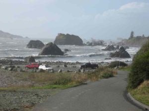
From the Point St. George parking lot at the end of Radio Road, CCT follows the road shoulder southeast over a dramatic unspoiled headland with views of near and far shores. Where the road turns southeast at ⅝ mile, take the path that climbs south over the grassy bluff. At ¾ mile you reach the top of the bluff where you look south to towering Castle Rock, an important seabird rookery, and west to St. George Reef Lighthouse seven miles out to sea. Descend south toward Castle Rock.
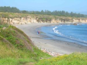
By ⅞ mile, about 200 feet before the end of the southernmost point, veer left on a single track trail descending east-southeast through grasslands to a rocky beach before one mile. Follow the beach northeast about ⅛ mile, observing the coast ahead. The beach narrows as it turns east then southeast. At a moderate to low tide you can continue southeast along the sometimes sandy, sometimes rocky Pebble Beach. When the tide is high you'll need to walk along Pebble Beach Drive which follows the blufftop above the beach. If you cannot walk the beach beyond 1⅛ miles, follow a faint path north just before a gully to return to Radio Road.
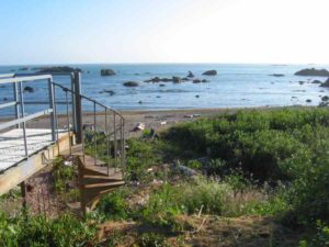
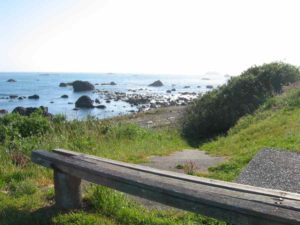
Our description assumes a high tide and follows Pebble Beach Drive, but at lower tides you can follow the beach. Follow Radio Road east to the Washington Blvd./Pebble Beach Drive intersection around 1⅜ miles, then turn right and walk the generally broad shoulder of Pebble Beach Drive. At a turnout at 1¾ miles a path offers the first chance to return to the beach. Beyond 2⅛ miles the beach is so narrow you can only walk it at low tide. As you continue along the now residential street, three stairways provide access between beach and bluff. They are located at 2½, 2⅞ and 3⅞ miles along your route.
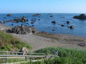
Before Preston Island at 3½ miles, the rocky shore lacks any beach, forcing you onto the bluff where a pleasant paved path provides shoreline views and good footing out of the traffic. At Preston Island, which is actually a peninsula, a paved road serves as a short side trail to the pebble beach and tide pool area where there are picnic tables.
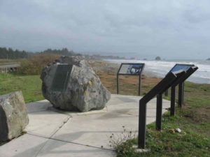
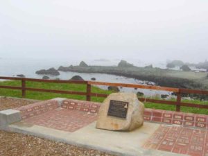
CCT continues along Pebble Beach Drive to Brother Jonathan Park at 3⅝ miles. The small park memorializes the 213 people who lost their lives in the 1865 shipwreck of the Brother Jonathan off Point St. George. Restrooms are available and a picnic table sits on the point overlooking the shore. Follow Pebble Beach Drive east for its final two blocks, then walk Taylor Street to the end of Fifth Street where you can return to the beach via a stairway unless it's high tide. In that case you'd need to follow Fifth Street to A Street, then turn right and walk A Street to its end at Battery Point at 4⅜ miles.
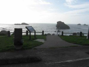
At Battery Point a side trail passable only at low tide leads ⅛ mile out to the 1856 Crescent City Lighthouse on a spectacular site on the rocky point. Tours are available in season and you can use the picnic tables anytime you can reach them, but don't get stranded by a rising tide.
ALTERNATE ROUTE: At low to medium tide you can follow the beach rather than Pebble Beach Drive for much of this section.
SUGGESTED ROUND TRIPS & LOOPS: You can take short to medium walks here. We recommend the trail at ⅝ mile that leads out onto the dramatic headland and down to the beach, the short side trips to Preston Island and Battery Point, or a brisk walk along the road shoulder and/or down one of the stairways and along the beach.
HOW TO IMPROVE CCT HERE: Acquire more of Point St. George for public access. The state has been negotiating with the owners about a potential purchase.
Distance: 4⅜ miles (7 kilometers).
Open to: Hikers, road portions open to bicyclists.
Surface: Beach, city streets, paved trails.
Access point: Point St. George.
How to get there: From the north end of Crescent City, take Washington Blvd. west from Highway 101. After the intersection with Pebble Beach Drive around 1.8 miles, Washington becomes Radio Road, which you follow to its end at 3 miles.
Other access: Anywhere along the route.
Difficulty: Easy
Elevation gain/loss: 110 feet+/130 feet-.
Cautions: Some of the beaches along this section are impassable at medium to high tide.
Further information: Crescent City Public Works Department: (707) 464-9506.
Facilities: None at access point. Restrooms, water, phone, picnic areas along route and at south end.
Campgrounds: Shoreline Campground in heart of town on Del Norte Section 5.
Lodging: Many motels in Crescent City.
Points of Interest
In the News
Interested in contributing to this project?
Register to add new photos and information, update existing results and share your trip reports.