
Usage Notes

Legend: For details on the icons and trail colors, please click the legend icon on the map above.

Layers: Other layers are available. See the California Coastal Commission and Coastal Conservancy Completed Sections layer for the official completed trail segments. (About progress on the trail completion project.)
Humboldt Section 2
Gold Bluffs Beach Campground, Prairie Creek Redwoods State Park, to Redwood Information Center, Orick
This section, the longest since CCT left the Oregon border, divides nicely into two segments, the wild and verdant 7⅛ miles of beach and trail/forest walking, and the road-highway-levee walk through the tiny town of Orick. You start in the southwest corner of Prairie Creek Redwoods State Park, pass through enchanting forest in a little visited corner of Redwood National Park, then drop to Highway 101 before following the levee of Redwood Creek through town to finish at the park's southern visitor center.
Walk west from the campground to follow the tideline south along broad Gold Bluffs Beach. It is 1¾ miles to where Davison Road leaves the beach near Espa Lagoon, heading east to Highway 101. CCT continues south along the beach for another 1⅜ miles, crossing a small creek west of Espa Lagoon, then fording Major Creek, site of another 19th-century gold mine, around 2⅝ miles.
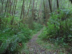
After you cross a small creek at 3 miles, watch on your left for an orange triangle and a sign marking the northern end of the Skunk Cabbage Creek Trail before 3⅛ miles. Leave the beach here and take the trail ascending the steep bluff by steps and switchbacks. After passing through a tunnel of coastal scrub, you gain a ridgetop with views of the creek canyon to the east and the ocean to the west. Ascend south along the ridgetop above a magical stretch of fern-lined creek where osprey nests decorate twisted Sitka spruce.
Make a steep winding climb that soon turns away from the creek, crossing a boardwalk at 3⅞ miles. Continue along the ridgetop on a gradual ascent, passing an immense charred redwood stump around 4⅛ miles. You crest a ridge around 4⅜ miles and make a steep twisting descent through redwood forest east of the ridge.
Drop to a trail junction on the ridgetop beyond 4⅝ miles. The right fork leads quickly to an overlook and rest bench. Take the left fork heading east into dense spruce forest at the headwaters of Skunk Cabbage Creek. A winding descent crosses several small bridges, then crosses a bridge across Skunk Cabbage Creek around 5¼ miles. The descent eases through lichen-draped forest, crossing more tributaries.
At 5⅞ miles, you cross Skunk Cabbage Creek again just below the confluence of its two main forks. Climb gently angling away from the creek. Your trail joins an old road beyond 6⅛ miles, contouring above the creek across numerous side streams. On your left around 6⅜ miles, abundant skunk cabbage grow in the broad, marshy bed of the creek that bears their name. After two more boardwalks, your trail descends a steep hill, dropping toward Johnson Creek. You pass several ancient redwoods spared when the surrounding forest was logged. Cross the creek on one more bridge and climb briefly to the parking area at Skunk Cabbage Creek Trail's southern trailhead at 7⅛ miles. CCT follows the gravel road out of the parking area, coming to a paved road at 7¾ miles. Descend the pavement to Highway 101 at 7⅞ miles.
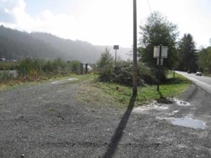
CCT turns right to follow Highway 101 south into Orick. Cautiously cross the highway and follow its east shoulder above the placid waters of Prairie Creek. At 8¼ miles you cross Bald Hill Road. Prairie Creek empties into much larger Redwood Creek beyond 8½ miles.
Shortly after the confluence, veer left on gated gravel road that follows the Redwood Creek levee south through the town of Orick. At 9⅜ miles creek and levee swing west to pass under Highway 101. At the highway crossing, follow the levee trail beneath the bridge. You want to cross the creek to follow the levee now on its south shore. It is easy to leave the levee near the bridge if you want to stop in town for supplies.
Follow the south levee west to the edge of town at 10¼ miles. Behind the Shoreline Market you have a choice. You can leave the levee and walk through the market parking lot to return to Highway 101, then follow the highway west to Redwood Information Center at 11½ miles, the route recommended in winter and spring. In summer and fall, continue along the levee as it winds north and south with the creek until 11⅝ miles, where you are just northeast of the Information Center, then head southwest to reach it at 11¾ miles.
ALTERNATE ROUTE: Generally only passable in summer at extremely low tides, the Beach Route continues south along the tideline around Mussel Point (the first questionable passage) and on down the beach to Hufford Point (second questionable passage) to the mouth of Redwood Creek (seasonal ford) where if you can ford you'll come to the Redwood Information Center in ⅜ mile. Total length: 6¾ miles.
SUGGESTED ROUND TRIPS & LOOPS: Follow the trail as described, either from Gold Bluffs Campground or Espa Lagoon. When you get to the southern trailhead for Skunk Cabbage Creek Trail, turn back and retrace your steps.
Distance: 11¾ miles or 11½ miles if walking highway at end (18.9 or 18.5 kilometers).
Open to: Hikers. Road and levee open to bicyclists.
Surface: Beach, trail, highway shoulder, levee.
Access point: Gold Bluffs Beach Campground.
How to get there: Turn west off Highway 101 north of Orick at Milepost 124.8 onto unpaved, steep and winding Davison Road. Go 7 miles to Gold Bluffs Beach Campground.
Other access: Espa Lagoon, Skunk Cabbage Creek Trailhead, or various points in Orick.
Difficulty: Moderate
Elevation gain/loss: 640 feet+/ 640 feet-.
Cautions: Use extreme caution on Highway 101.
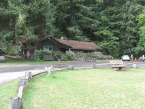
Further information: Prairie Creek Redwoods State Park (707) 464-6101, ext. 5300. Redwood National Park (707) 464-6101, ext. 5265.
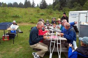
Facilities: Chemical toilets and water at campground. Picnic area on Davison Road about ⅜ mile south of the campground.
Campgrounds: Gold Bluffs Beach Campground has primitive car camping with solar showers. Nearby Miner's Ridge Hike/Bike Camp has sites off the road. Orick RV Park, north end of town, is a private campground on this section.
Lodging: Park Motel is on Highway 101 at start of Davison Road. Several motels are in Orick.
Points of Interest

In the News
Interested in contributing to this project?
Register to add new photos and information, update existing results and share your trip reports.