
Usage Notes

Legend: For details on the icons and trail colors, please click the legend icon on the map above.

Layers: Other layers are available. See the California Coastal Commission and Coastal Conservancy Completed Sections layer for the official completed trail segments. (About progress on the trail completion project.)
Humboldt Section 1
Carruthers Cove Trailhead to Gold Bluffs Beach Campground, Prairie Creek Redwoods State Park
As CCT leaves the Coastal Drive to descend Carruthers Cove Trail, it enters pristine 15,000-acre Prairie Creek Redwoods State Park, one of California's finest and earliest state parks, established in the 1920s. As you descend an old homestead road to the hidden shore, you enter Humboldt County. When you reach the sand-filled cove, immense rock outcrops towering overhead dwarf human scale, encouraging a feeling of awe for this rugged meeting of virgin-forested land and wild sea.
As recently as 1992, the beach south was passable only at low tide, but recent abundant sand deposits made it passable at any tide. That's the good news. The bad news is that the sand buildup now allows commercial fishermen to drive their vehicles along the beach of this recently wilderness coast. After 2½ miles you can leave the beach for the solid footing of CCT along the base of the Gold Bluffs, site of 19th century mining.
Take the Carruthers Cove Trail as it drops to the old roadbed you descend to the beach. The overgrown road descends steadily, winding through forest of Sitka spruce and alder. Beyond ½ mile you may glimpse the coastline to the north, but mostly the shore remains hidden until ¾ mile where your trail passes a homestead site and turns right for your first view of the massive rock outcrop at the mouth of Johnson Creek.
The trail descends moderately across the steep slope below the homestead. At the base of the slope, make your way through piles of driftwood to firm footing on the beach sand by ⅞ mile. Walk south across the level sand of Carruthers Cove to the base of the rock outcrop at one mile. A seasonal lagoon may require you to veer west toward the nearby Pacific shore. The beach stretches north and south along the base of steep cliffs with the impressive dome of Split Rock rising 533 feet from the breakers two miles north.
CCT heads south along the broad beach. Between 1⅝ and 1¾ miles, several rock outcrops or sea stacks lie along the tideline. Continue along the broadening beach, coming to the Ossagon Rocks at 2¼ miles where the largest outcrop is up on the beach with more rocks at the surf line. You can see the canyon of Ossagon Creek not far to the southeast. Follow the beach to 2½ miles where you're directly west of the Ossagon Trail where it drops to the coastal plain.
CCT offers a choice of two routes south from here. You can choose to follow the tideline all the way to Gold Bluffs Beach Campground at 6⅛ miles. The more diverse and engaging route heads east or southeast to the Coastal Trail along the base of the bluffs. It's about ⅛ mile east across sometimes swampy ground to the trail at the mouth of Ossagon Creek Canyon. Ossagon Creek Camp there requires a reservation to stay overnight. In winter and early spring when the Coastal Trail from Butler Creek south may be wet or flooded, it's often better to stay on the beach for at least 1½ miles.
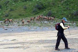
Our description heads east from 2½ miles, crossing sand to enter alder forest along Ossagon Creek. Near the creek crossing where the camp sits beside the trail, a sign points uphill for the Ossagon Trail to Drury Parkway. You want the trail south, which leaves the alder forest south of the ford to head south across flat coastal prairie. Keep your eyes open for the wild elk that favor this area; you may need to detour to stay out of their way.
CCT soon climbs along the hillside, contouring above the dunes for about ½ mile. Before your trail descends. to Butler Creek, West Ridge Trail heads east, following a ridge through virgin forest to the park's visitor center in 7⅜ miles. Descend to ford Butler Creek at 3 miles.
The Coastal Trail continues south, leaving alder forest to parallel the base of the Gold Bluffs through grasslands. In a wet winter or spring you may need to detour ¼ mile west through the dunes to avoid standing water on the next mile of trail. If it's not flooded, follow the trail past a large spruce snag and over a small rise. Pass a gravelly slide and veer to the right of some alders around 3½ miles. The roar of the surf echoes loudly from the cliff above as you skirt spruce forest along the base of the wooded bluffs.
Before 4 miles a short side trail forks left to an 80-foot waterfall hidden in the forest. CCT meets another short spur on the left in 300 feet. It leads to a rest bench beside Gold Dust Falls where a small stream plunges 100 feet to disappear into the sandy soil beneath the spruce forest. Not far beyond, a third waterfall dives off the cliff in wet season.
CCT rounds a small point at 4¼ miles from which you can look south to the alder thicket marking Boat Creek. Cross lupine-studded grasslands, then wind through the alders to ford Boat Creek where it emerges from its rugged canyon at 4¾ miles. Continue south through grasslands and into more alder forest. The James Irvine Trail forks left at 5⅛ miles, ending at the visitor center in 4¼ miles. It also leads to nearby Fern Canyon Loop, a fine ¾-mile loop through a narrow canyon with fern-draped vertical walls 60 feet high.
CCT fords Home Creek and continues south to meet the end of Gold Bluffs Beach Road at 5⅜ miles, where the new Fern Canyon parking area has restrooms. The Coastal Trail continues south along the dirt and gravel road, hugging the base of the Gold Bluffs. It's a pleasant, lightly traveled one mile along the road to section's end at 6⅜ miles at Gold Bluffs Beach Campground, in the dunes between road and beach just south of Squashan Creek. Another overnight choice is nearby Miner's Ridge Hike/Bike Camp which sits on a knoll east of the road. If you're still game for exploration, pleasant Miner's Ridge Trail follows Squashan Creek east before climbing over a ridge to the visitor center in about 4 miles.
ALTERNATE ROUTE: You can follow the tideline south of Ossagon Creek instead of walking east to the Coastal Trail.
SUGGESTED ROUND TRIPS & LOOPS: Carruthers Cove Trail to the beach offers a wonderful short round trip. You can continue south to Ossagon Creek and return from there, or loop back by ascending Ossagon Trail and return on Drury Parkway and Coastal Drive. Other pleasant choices start from Fern Canyon Trailhead. You can walk north on the Coastal Trail to Butler Creek and back, 5¼ miles, or Ossagon Creek, 6¼ miles, or make a 7½-mile loop by turning east on West Ridge Trail, then returning south along Friendship Ridge Trail. Also consider the short one mile loop through amazing Fern Canyon.
Distance: 6⅜ miles (10.3 kilometers).
Open to: Hikers. Bicyclists from Ossagon Trail south.
Surface: Trail, beach, gravel road.
Access point: Carruthers Cove Trailhead.
How to get there: Turn west off Highway 101 north of Orick and south of the Klamath River onto N. B. Drury Parkway at Milepost 137.45 (Humboldt County) from south, .Milepost 0.3 (Del Norte County) from north. Go south .9 mile and turn right on Coastal Drive. Go 1.0 mile to trailhead on left marked by a sign "COASTAL TRAIL."
Other access: Via Ossagon Trail.
Difficulty: Easy
Elevation gain/loss: 40 feet+/580 feet-.
Cautions: Stay away from wild elk. Mountain lions also frequent this area.
Further information: Prairie Creek State Park (707) 464-6101, ext. 5300.
Facilities: None at access point. Chemical toilets at Ossagon Creek Camp and Gold Bluffs Beach Campground. Water at Gold Bluffs Beach Campground or purified from creeks. Toilets near Fern Canyon at end of Gold Bluffs Beach Road.
Campgrounds: Ossagon Creek Camp on the trail at 3 miles must be reserved in advance through Prairie Creek Redwoods State Park. Gold Bluffs Beach Campground has car camping with solar showers. Nearby Gold Bluffs Hike/Bike Camp has no auto access.
Lodging: Park Motel is on Highway 101 at Davison Road. Other motels are in Orick. DeMartin Redwood Hostel is 11 miles north.

Interested in contributing to this project?
Register to add new photos and information, update existing results and share your trip reports.