
Usage Notes

Legend: For details on the icons and trail colors, please click the legend icon on the map above.

Layers: Other layers are available. See the California Coastal Commission and Coastal Conservancy Completed Sections layer for the official completed trail segments. (About progress on the trail completion project.)
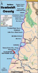
Humboldt Section 9
Mouth of Humboldt Bay, South Side, to Mouth of Eel River
Unlike most CCT sections, this section and the next one have no vehicle access to their northern access points. (This section may change in summer 2002 if South Spit Road reopens.) This means you need to walk several miles to reach the northern access points unless you take a boat, across Humboldt Bay for this section, across the Eel River for the next. Humboldt County closed South Jetty Road to vehicle traffic at the end of 1997. Day hikers need to park at Table Bluff County Park and walk down the road .3 mile to the base of the bluff where the road turns northeast, running 4.4 miles to the end of the South Spit. The Coastal Trail follows the beach west of the road.
The most remarkable feature of the South Spit is the extensive tidal flats of Humboldt Bay along its eastern shore. At high tide the South Bay looks like a very large body of water, but when the tide drops below 0.0 feet, most of it becomes a giant mud flat where abundant shore birds gather and forage. To best observe the wildlife when you visit at low tide, consider walking along the western shore of Humboldt Bay east of the road. Much of the bay is in the Humboldt Bay National Wildlife Refuge.
At moderate to high tide it's better to follow CCT along the western shore.
Most of the land on South Spit that was privately owned until 2000 is now held by the California Department of Fish and Game. The South Jetty Road is also public, and of course you always have the right to walk the beach below the mean high tideline.
If you crossed Humboldt Bay from the North Spit in a boat, the skipper probably dropped you on the eastern point at the tip of the South Spit. If so, walk west along the curving track for about ½ mile to South Jetty Road. Walk north ¼ mile to the end of the road, then walk northwest near the sea wall, coming to the base of the South Jetty before ¼ mile. The jetty extends ¾ mile out to sea but is extremely prone to rogue waves.
From the South Spit's northern tip, the Coastal Trail follows the western shore on another long beach walk. By ¾ mile you are west of the intersection of the main road and east road. Continue along the firm sand at tideline. At 3¼ miles the sand spit narrows to barely one-tenth mile wide. As you continue along the beach, the spit By 5 miles you draw even with Table Bluff as it broadens and the green rise of Table Bluff ahead grows prominent. rises 170 feet above the beach.
South Jetty Road ends at the hairpin turn just east of the beach, becoming Table Bluff Road as it climbs by switchbacks to the top of the bluff.
CCT continues south from Table Bluff along the dark sand beach for about 2½ miles to the broad mouth of the Eel River. That mileage is approximate because the mouth of the Eel River moves irregularly as the powerful river shifts the unstable sands around its mouth. In a seven-year period from 1988 to 1995 the mouth of the river moved nearly two miles north. To continue south on CCT from the river mouth requires a boat. Even if you find someone with a boat who is willing to shuttle you across, winds and tides must also be in your favor. Call Humb Boats and see if they can arrange a shuttle. If not, through-hikers must follow the Alternate Route from Table Bluff.
To follow CCT south from Table Bluff, walk the tideline ⅛ mile to the base of the westernmost point of the bluff. Then continue south-southwest along the hard sand near the tideline. By 6½ miles McNulty Slough lies ⅜ mile east of the shore. By 6¾ miles a smaller slough is only ⅛ mile east. At 7 miles you begin to parallel North Bay Slough with large stacks of driftwood along the high tideline between you and the slough. Somewhere around 7½ miles you come to the mouth of the Eel River. You can't miss the only outlet for California's third largest river!
ALTERNATE ROUTE: If you're through-hiking and cannot arrange a boat shuttle across the Eel River near its mouth, take the following route south from Table Bluff. It will bypass the rest of Section 9 and all of Section 10. Walk Table Bluff Road south and east 2⅛ miles. Turn right on Copenhagen Road and walk it to its end at Eel River Drive at 5½ miles. Turn right and walk south on Eel River Drive through Loleta and into Fernbridge at 8⅛ miles. At Fernbridge turn right on Highway 211 and cautiously walk the busy highway shoulder southwest for 5 miles to Ferndale. At the south end of Main Street, turn right on Ocean Street and go one block. Humboldt Section 11 starts where the Mattole Road climbs from Ocean Street. The detour is about one mile shorter than the portion of CCT it bypasses, but not nearly as pleasant a hike.
SUGGESTED ROUND TRIPS & LOOPS: The nicest walk here starts at Table Bluff and follows the beach south to the mouth of the river, then returns along the high side of the beach with views over the sloughs, about 5 miles round trip, passing through the Eel River Wildlife Area.
Distance: 7½ miles (12.1 kilometers).
Open to: Hikers, equestrians.
Surface: Beach.
Access point: North end of South Jetty.
How to get there: Take a boat across the bay or walk north from Table Bluff. If South Spit Road reopens to the public in summer 2002 as planned, you will once again be able to drive to the access point.
Other access: Table Bluff County Park. Exit Highway 101 south of Eureka at Milepost 68.0 from south, Milepost 68.15 from north onto Hookton Road and follow it west. In 3 miles it merges with Table Bluff Road. Continue 2 more miles to Table Bluff County Park. Where road is closed .2 mile farther, park near the gate. (If South Spit Road has reopened to the public, you can drive the 4.7 miles to northern access point.)
Difficulty: Easy
Elevation gain/loss: None for CCT. From Table Bluff: 170 feet+/170 feet-.
Cautions: Watch for oversize waves when walking the beach. No camping on South Spit.
Further information: Humboldt County Parks (707) 445-7652, Humboldt Bay National Wildlife Refuge (707) 733-5406. For boat shuttle call Humb Boats (707) 443-5157.
Facilities: None
Campgrounds: KOA in Fortuna.
Lodging: Many are available in Eureka and Fortuna.
Points of Interest
No individual points found.
In the News
Interested in contributing to this project?
Register to add new photos and information, update existing results and share your trip reports.