
Usage Notes

Legend: For details on the icons and trail colors, please click the legend icon on the map above.

Layers: Other layers are available. See the California Coastal Commission and Coastal Conservancy Completed Sections layer for the official completed trail segments. (About progress on the trail completion project.)
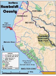
Humboldt Section 10
Mouth of Eel River to Centerville Beach to Ferndale
If you took a boat shuttle across the Eel River near its mouth, this section offers a simple walk along the beach, followed by a road walk east to Ferndale where Humboldt Section 11 begins. Otherwise through-hikers will bypass this section altogether as they make the long road walk detour east through Loleta and Fernbridge (see Humboldt Section 9 Alternate Route).
If you're day hiking this section, start at Centerville Beach County Park and follow the beach north to the mouth of the Eel River. Whichever way you hike it, the beach distances are approximate due to the Eel River's tendency to move its mouth north or south from year to year. We based our report on the location of the river mouth in July 1997.
From the river's mouth walk west to the firm sand at the tideline, then follow it south-southwest along the sand spit between the Pacific Ocean and the Eel River. As you head south, Cannibal Island lies across the river to the east, then smaller Mosley Island appears across the river. By 1¼ miles you're opposite tiny Crab County Park on Mosley Island's west shore.
From 1½ to 1⅞ miles along the beach, the Eel River swings to the east. It's extremely broad at this spot. The tiny Salt River enters the Eel from the south just east of the barrier beach at this point. The sandbar you just crossed was the location of the Eel River mouth as recently as 1988.
As you continue down the beach, it soon turns from a barrier beach or sand spit to a long beach backed by low sand dunes which in turn are bordered by sloughs and canals. You might see the first large dune to the east around 2¾ miles. The dunes are taller again beyond 3⅝ miles. Around 3⅞ miles the westernmost dune is only 200 feet from the surf.
The tideline jogs westward between 3⅞ and 4⅝ miles. Watch for abundant sea birds over the surf, including cormorants, seagulls and pelicans. Shore birds abound including sandpipers and sanderlings. Beyond the low dunes to the east many migratory birds, the abundant Canada geese and tundra swans to name two, spend their winters sharing the area with the egrets and herons that reside here.
Around 4⅜ miles Cutoff Slough lies about ⅜ mile east of the tideline. The beach has gradual slope here, but by 4¾ miles it steepens. Between 5 and 5¼ miles the beach is so steep you cannot see the dunes from the tideline. Narrow Centerville Slough lies just east of the dunes until around 5¾ miles.
Now it is less than a mile to the parking lot for Centerville Beach County Park. Watch for signs of the lot around 6⅝ miles where you want to turn east for ⅛ mile to meet Centerville Road. It would be easy to miss the parking lot in the fog and continue down the beach. If you see sandstone cliffs rising east of the beach, turn back, you've gone too far.
Where the parking lot meets Centerville Road at 6¾ miles, you want to turn left toward Ferndale and follow Centerville Road's shoulder east along the base of the hills at the edge of the river's flood plain. You pass Poole Road on the right before 7⅝ miles. Continue along Centerville Road, crossing Russ Creek and passing Fern Cottage before 9 miles. 9 Pass Meridian Road on the left around 10½ miles, then cross Reas Creek. By 11 miles you approach Ferndale. The road jogs south briefly, following Ocean Drive into town and meeting the Mattole Road on the right at 11¾ miles, start of Section 11.
ALTERNATE ROUTE: See Humboldt Section 9 Alternate Route.
SUGGESTED ROUND TRIPS & LOOPS: It's an all day beach walk from Centerville Beach County Park to the mouth of the Eel River and back.
Distance: 11¾ miles (18.9 kilometers).
Open to: Hikers, equestrians.
Surface: Beach, paved road.
Access point: Mouth of Eel River.
How to get there: Leave Highway 101 south of Eureka at Ferndale exit, Milepost 64.5 from north, Milepost 62.9 from south. Cross Fernbridge and go west 5 miles through Ferndale. At south end of Main Street, turn right and go 5 miles to Centerville Beach parking lot.
Other access: Centerville Beach.
Difficulty: Easy
Elevation gain/loss: None for beach. Centerville to Ferndale: 225 feet+/145 feet
Cautions: Watch for off-road vehicles on beach.
Further information: Humboldt County Parks (707) 445-7652.
Facilities: None except restroom, water, phone at Ferndale.
Campgrounds: County Fairgrounds north of Ferndale allows camping. Fortuna has a private campground.
Lodging: Ferndale has several.
Points of Interest
In the News
Interested in contributing to this project?
Register to add new photos and information, update existing results and share your trip reports.