
Usage Notes

Legend: For details on the icons and trail colors, please click the legend icon on the map above.

Layers: Other layers are available. See the California Coastal Commission and Coastal Conservancy Completed Sections layer for the official completed trail segments. (About progress on the trail completion project.)
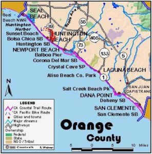
Los Angeles Section 12
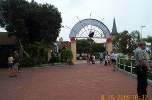
Shoreline Village, Long Beach to Seal Beach Pier
This section features a walk from the big city of Long Beach, the fifth largest in California with a population of 442,000, to the relatively lazy backwater town of Seal Beach with a population of 26,000 and a short, tree-lined Main Street ending at the pier. The massive Long Beach Convention Center represents one view of what's important and the locals hanging out in Eisenhower Park at the base of Seal Beach Pier represent another.
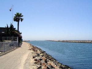
Before heading for Seal Beach, take a short detour on the jetty sidewalk in front of Shoreline Village for a closer look at the 1,020-foot long Queen Mary across the channel. The world's largest ocean liner landed here for keeps in 1967 after being retired in 1964.
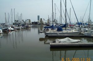
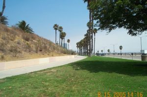
From Shoreline Village walk the bike path east past the small boat marina to the 4-mile long beach for which the city was named. Walk down the tideline of the wide, sandy, usually surfless beach. The islands in the bay, designed to look like modern high rise buildings, hide oil rigs pumping black gold from beneath the bay. Walk down the long beach which is tucked at the base of 40-foot bluffs that partially hide the dense city just inland.
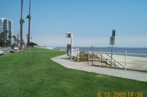
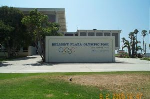
Around 1⅜ miles Bixby Park sits on a knoll above the beach. Continue down the beach, passing Bluff Park from 1¾ miles to 2½ miles. You reach Belmont Pier, 1620 feet long, at 2⅞ miles. Continue down the beach with the bluffs soon giving way to the nearly level Belmont Shore neighborhood.
Further down the beach at 4 miles, turn inland at 54th Place, identified by a house on the beach. You start the walk around Alamitos Bay through Naples here. You can walk either pleasant Alamitos Bay Beach on the bay side or Bayshore Avenue above it. Turn right onto Second Street and walk through the lively business district to Marina Drive at 5½ miles, where you turn right. Walk either along the marina frontage or stay on the sidewalk of Marina Drive.
At 6½ miles follow Marina Drive as it makes a left turn to cross a bridge over the San Gabriel River into Orange County and Seal Beach. Turn right on First Street, walk to its end and walk onto the beach. Turn left for a short stroll to the Seal Beach Pier and the end of the section at 7⅜ miles.
SUGGESTED ROUND TRIPS AND LOOPS: To stretch out your legs and get some exercise, walk the entire 4½-mile length of Long Beach City Beach from 1st Place by Shoreline Aquatic Park to 72nd Place at the entrance to Alamitos Bay.
Distance: 7⅜ miles (11.9 kilometers).
Open to: Hikers. Bicyclists on streets.
Surface: Beach, sidewalk.
Access point: Shoreline Village, Long Beach.
How to get there: Take the Long Beach Freeway I-710) to the Shoreline Drive exit in Long Beach. Go 1.2 miles on Shoreline Drive to the foot of Pine Avenue. Shoreline Village is on the waterfront east of the Shoreline Park Lagoon and west of the marina near downtown Long Beach.
Other access: Anywhere on the route.
Difficulty: Easy
Elevation gain/loss: Negligible.
Cautions:
Further information: For Long Beach City Beach, Belmont Shore and Alamitos Bay Beach, call Long Beach Lifeguard Service (562)570-1341. For Seal Beach, call the Seal Beach Lifeguard Station (562)430-2613.
Facilities: Shoreline Aquatic Park and Bixby Park have restrooms, picnic tables and water with the usual urban amenities just inland from Shoreline. Belmont Pier has restrooms and a snack bar. Alamitos Bay Beach has restrooms.
Campgrounds:
Lodging: Long Beach has many hotel rooms. Stay on the Queen Mary for a unique experience.
Points of Interest

In the News
Interested in contributing to this project?
Register to add new photos and information, update existing results and share your trip reports.