
Usage Notes

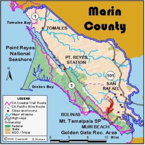
Legend: For details on the icons and trail colors, please click the legend icon on the map above.

Layers: Other layers are available. See the California Coastal Commission and Coastal Conservancy Completed Sections layer for the official completed trail segments. (About progress on the trail completion project.)
Marin Section 6
Palomarin Trailhead, Point Reyes National Seashore, to Bolinas
The Coastal Trail from Palomarin to Bolinas offers a choice of two very different routes. The alternate beach hike is a spectacular low-tide-only route. The Bolinas Mesa route crosses rolling headlands over ranch lands recently acquired for the national seashore, then winds into town, getting you there without wet feet.
From the Palomarin parking lot, take the gravel road south. Follow it past the Point Reyes Bird Observatory (visitors welcome, restrooms open to the public), cross the bridge over wooded Arroyo Hondo, then pass the Ridge Trailhead. At 1¼ miles you meet a driveway marked "COMMONWEAL 451." A few steps west on the driveway, go left through a gate into a new addition to Point Reyes leased to a rancher. Please don't disturb his cattle. Follow the farm road southwest. Look south to see the first of two rows of eucalyptus trees ¾ mile away. Around 1¾ miles, turn off the road and head south across the trailless pasture toward the upper end of the trees. Pass to the left of the trees and angle southeast toward the second row of trees. Find and pass through a gate in the fence paralleling the tree line at 2¼ miles. Beyond the gate your route angles east downhill towards the upper end of the second set of trees. Cross the ravine at 2½ miles on rough tread where the trail cuts deeply into the creek bank. Hop across the creek and climb up the other side.
The overgrown trail follows the side of the ravine, turns uphill to pass through a gate and reach the top of the hill. Before 3 miles you go through another gate to Poplar Road. You leave Point Reyes National Seashore and enter the residential part of Bolinas with its grid of mostly unmarked roads in varying states of disrepair, from completely overgrown and impassable to paved and potholed, and an eclectic and charming mix of houses. Go left on Poplar to its end beyond 3½ miles.
Turn right on Beach Street for a few blocks. After it jogs to the left and ends, turn right and walk Overlook Drive to its end. Turn left on Terrace Avenue and walk ¾ mile to Bolinas Road at 4¾ miles. Left leads off Bolinas Mesa to Highway 1. Turn right and walk through the funky commercial center of Bolinas. Only a few blocks long, it includes a grocery store, bakery, bar, local museum, some tourist stores, and a gas station. Soon the wildlife-rich Bolinas Lagoon will be on the left with houses built on pilings in the channel. Both road and trail end at Bolinas Beach at the mouth of the lagoon around 5 miles.
LOW TIDE ALTERNATE ROUTE: This is a great walk at low tide but not recommended if the tide has turned. Allow about 2½ hours to do the 5-mile walk. From the Palomarin Trailhead, follow Coast Trail northwest for about ⅛ mile to find the newly rerouted Palomarin Beach Trail. Turn left and follow the trail about ¾ mile down the bluff to the beach.
The tidal area below the bluffs, only 2 miles from Bolinas, feels wild and remote. Most of the route south is easy going on sand and rocks, but for several hundred yards north of Duxbury Reef you walk on slick tidal rocks. Low tides expose a wide area of tilted and wave-cut sedimentary rocks great for tidepooling. The reef stretches about 2 miles between Bolinas Point and Duxbury Point. You can leave the beach at several places if the tide is too high. Beyond 2 miles a trail cuts up to Agate Beach County Park, and beyond 4 miles, short steps from a residential street reach the beach. Take care if attempting to climb the steep and crumbling bluffs anywhere else. The walk ends at the mouth of Bolinas Lagoon, with downtown Bolinas only a short walk up the road.
SUGGESTED ROUND TRIPS & LOOPS: Combine the Mesa route and beach route for a great 10 mile loop. Time your beach walk to make sure the tide is out or going out.
Distance: 5 miles (8 kilometers).
Open to: Hikers. Bicyclists on road.
Surface: Trail, road shoulder. Alternate Route on beach and tidal rocks.
Access point: Palomarin Trailhead, Point Reyes National Seashore, to Bolinas
How to get there: Five miles north of Stinson Beach on Highway 1, turn west on unmarked Bolinas Road. Go 1½ miles to Mesa Road. Turn right and go 5 miles to the trailhead.
Other access: Along Mesa Road and in Bolinas.
Difficulty: Easy
Elevation gain/loss: 240 feet+/480 feet-.
Cautions: Don't disturb cows on the grazing land. Leave the ranch gates just like you find them. Dangerous surf and slippery rocks on beach route.
Further information: Point Reyes National Seashore (415)464-5100.
Facilities: Palomarin has chemical toilets. Bolinas has the usual small town services.
Campgrounds: Olema has a private campground and Samuel P. Taylor State Park, 6 miles east, has camping.
Lodging: Bolinas has Thomas' White House Inn. Olema and Stinson Beach have choices.
Points of Interest
No individual points found.
In the News
Interested in contributing to this project?
Register to add new photos and information, update existing results and share your trip reports.