
Usage Notes

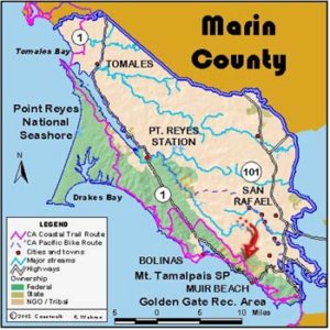
Legend: For details on the icons and trail colors, please click the legend icon on the map above.

Layers: Other layers are available. See the California Coastal Commission and Coastal Conservancy Completed Sections layer for the official completed trail segments. (About progress on the trail completion project.)
Marin Section 7
Bolinas Beach to Pantoll, Mt. Tamalpais State Park
To continue along the coast, you need to arrange a boat ride across the mouth of Bolinas Lagoon. If you can't get a ride, you have two alternate routes to choose from. All the routes lead high onto the flanks of Mount Tamalpais.
One hundred yards across the lagoon's mouth, Seadrift subdivision sits atop the sand spit defining the lagoon, the scene of a long-time battle over beach access. The public claimed the beach as public, the homeowners said it wasn't. Finally in 1998 the courts decided that you cannot be stopped from walking the tideline the length of the beach.
After the boat drops you east of the lagoon's mouth, walk the tideline southeast. At 2¼ miles the beachfront houses end and Stinson Beach Park, part of Golden Gate National Recreation Area, begins. Turn inland before 2⅝ miles to walk through the parking lot to Highway l and the middle of the village of Stinson Beach with its stores and restaurants, a good place to buy lunch.
Walk south along often busy Highway 1, then turn left on Panoramic Highway briefly to the Dipsea Trailhead on the right around 2¾ miles. Follow the Dipsea Trail on a stiff 1400-foot climb up the west flank of Mount Tamalpais. It climbs a hill, flattens out on a rolling terrace, and drops down to Steep Ravine Trail at 3¾ miles. Turn left and after a few yards, continue up the Dipsea Trail on the south side of the ravine.
Climb steeply to Cardiac Hill at 5¼ miles. Beyond 4¾ miles the trail braids with a fre road so that either the road or the trail gets you to the same place. Bikes are allowed on the fire road but not the single track path. At the top, where several paths converge at 5¼ miles, look for the trail sign to Pantoll. In 500 feet you can veer right on the parallel Old Mine Trail to get off the road. Continue ¾ mile up the hill to Pantoll and the end of the section.
ALTERNATE ROUTE A: The road route offers a pleasant walk albeit in the company of cars use extreme caution. From downtown Bolinas walk 2 miles along Bolinas Road to Highway l. Turn south and walk 5 miles to Stinson Beach, much of it along the shore of Bolinas Lagoon where wildlife abounds including wading birds, a harbor seal colony on a sand bar just off the road, and nesting egrets and blue herons at Audubon Canyon Ranch just across Highway 1 from the lagoon. If Audubon is open, consider it for a rewarding stop. Pick up the Dipsea Trail in Stinson Beach as described above and continue to Pantoll.
ALTERNATE ROUTE B: This inland route is much longer and more challenging but the fantastic scenic views from the ridge in every direction are worth it. From this trail you can see Bolinas, Stinson Beach, San Francisco Bay, San Francisco and the three highest peaks in the Bay Area: Mount Tamalpais, Mount Diablo, and Mount Saint Helena. If you do this all-day route, it replaces Sections 6 and Section 7 in one hike.
From the Palomarin Trailhead, walk ¾ mile south on the road and take the Ridge Trail on the left. At 2⅜ miles, turn right on the Teixeira Trail and descend into scenic Olema Valley along the infamous San Andreas Rift Zone. The trail ends at Highway 1 at 4⅝ miles. Find the McCurdy Trail directly across the road. It climbs 1200 feet in 1¾ miles to gain the top of Bolinas Ridge. Make a right on the Ridge Trail (a wide fire road, watch for mountain bikes) and walk 3 miles to Bolinas-Fairfax Road.
Cross the road and pick up the Coastal Trail. Bikes are not allowed on this single track trail and rangers actively cite illegal bike use. The trail traverses the west flank of Mount Tamalpais for 6⅜ miles. Around 2 miles the trail circles the head of a steep ravine on a road for 100 yards before dropping back below the road. Take the trail that angles slightly downhill. A side trail goes sharply down the slope here. Continue on the trail as it contours across a steep hillside. The trail ends at the Pantoll parking lot.
SUGGESTED ROUND TRIPS & LOOPS: Walk Stinson Beach north to the end of the spit, 5⅛ miles round trip. From Stinson Beach take the Dipsea Trail to Pantoll and return to Stinson down the Steep Ravine Trail, a rewarding 5¼ miles round trip.
Distance: 6 miles. Alternate A: 10 miles. Alternate B: 16¾ miles (9.7 or 16.1 or 27 kilometers).
Open to: Hikers.
Surface: Beach, trail.
Access point: Bolinas Beach.
How to get there: From Stinson Beach, drive 5 miles north on Highway 1. Turn west on unmarked Bolinas Road just beyond Bolinas Lagoon. Drive two miles and through Bolinas to road's end at the beach. Parking is restricted here, so parking in town might be easier.
Other access: Stinson Beach.
Difficulty: Hard
Elevation gain/loss: 1500 feet+/80 feet-.
Cautions: Use caution boating across the lagoon which has strong currents.
Further information: Mount Tamalpais State Park (415)388-2070.
Facilities: Full services are available at Bolinas and Stinson Beach.
Campgrounds: Pantoll Campground at Mount Tamalpais State Park.
Lodging: Stinson Beach and Bolinas have several choices. State Parks' Steep Ravine Cabins and Environmental Camps are superb, but usually require advance reservations.
Points of Interest
No individual points found.
In the News
Interested in contributing to this project?
Register to add new photos and information, update existing results and share your trip reports.