
Usage Notes

Legend: For details on the icons and trail colors, please click the legend icon on the map above.

Layers: Other layers are available. See the California Coastal Commission and Coastal Conservancy Completed Sections layer for the official completed trail segments. (About progress on the trail completion project.)
Monterey Section 6
Carmel City Beach to Point Lobos State Reserve Entrance
This hike follows the dramatic shoreline of the posh little seaside town of Carmel. Carmel originally gained fame as an artist's community, an important stop among the bohemian social circles of the early 20th century.
From the access point you can either walk the sparkling white sand beach or take the wooded, paved blufftop path above it. For the path, walk back up Ocean Drive to the first corner. Turn right and walk along Scenic. Road. You'll pick up the paved blufftop path ¼ mile from the parking lot. The description follows the beach route.
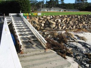
From the parking lot descend west 300 feet to the tideline. Turn left and walk the tideline south along the fine white sand beach. By ¼ mile a broad stairway on your left descends from the Scenic Road blufftop path. It's the first of eight stairways and a ramp linking the blufftop and the beach.
Continue along the broad beach, enjoying its dramatic setting bracketed by Point Lobos to the south and Pescadero Point to the northwest. Pass a stone stairway beyond ½ mile and continue to the end of the beach before ¾ mile. At low tide you might be able to continue over slippery tidal rocks, but not beyond nearby Carmel Point, occupied by a Frank Lloyd Wright-designed house.
The Coastal Trail turns southeast to leave the beach by the last stairway. At the top of the stairs, turn right and continue along the ocean-fronting shoulder of Scenic Road. While no developed path exists beyond the stairs, locals and visitors alike walk the road frequently--that's why there's a 15 MPH speed limit. Follow the blufftop as it swings toward Carmel Point with a last look at the beach below. After you round Carmel Point at one mile, parallel Scenic Road south with open ocean on your right and picturesque homes on the left. The big stone house before Stewart Way is Tor House, the home of poet Robinson Jeffers until he died there in 1961 (tours by reservation on Friday and Saturday, 831-624-1813). Before 1¼ miles both CCT and Scenic Road make a hairpin turn left. Walk another 250 feet along the shoulder to the corner of Ocean View Avenue, then take the stairway on the right that descends to Carmel River State Beach.
Walk the beach down near the tideline and follow it south. The beach becomes increasingly wild on the way to the mouth of the Carmel River, thanks to the Carmel River Nature Preserve to the east. Watch out for large waves along the steep tideline, backed by a dangerous undertow.
When you reach the mouth of the river before 1⅝ miles, you may have an easy ford of the highly seasonal stream, or perhaps the river mouth is closed off by the barrier beach. When the river runs high after winter and spring rains, however, you may need to turn back here. If you need to ford the river, it's best to walk 200 feet inland where the water calms before cascading to the tideline. Assuming you can reach the south shore of the river, continue south above the tideline. By 1¾ miles you pass some large rocks on the beach. Pick your way past the granitic rocks to return to a sandy beach with scattered rocks by 1⅞ miles. Follow the tideline of this curving beach until you encounter more large rocks before 2¼ miles. Turn left and ascend eleven steps to find a blufftop path. Follow it south, contouring along the bluff's edge for ⅛ mile. Then CCT descends to the beach and follows its graceful curve toward a divine looking church. Reach the mouth of San Jose Creek, usually an easy ford or a walk across a barrier beach at 2⅜ miles. Beyond the stream, follow the tideline as it swings southwest toward Point Lobos with Highway 1 drawing near on the left. Before you reach the fence at the end of San Jose Creek State Beach, you want to turn left and head for the restrooms, then walk up to Highway 1 at 2¾ miles.
The Coastal Trail turns right and follows the broad highway shoulder southwest for ¾ mile to reach the entrance of Point Lobos State Reserve, start of the next section. From Riley Ranch Road you can follow a pleasant path on the highway's west side that parallels the reserve's fence for the final ⅛ mile to the Reserve entrance.
SUGGESTED ROUND TRIPS & LOOPS: Walk City Beach to its end then return along the Scenic Road path for an easy 1⅝-mile loop. Walk the State Beach from the Scenic Road stairway or the highway end to Carmel River and return.
Distance: 3½ miles (5.6 kilometers).
Open to: Hikers. Dogs OK off leash on City Beach and on leash on State Beach.
Surface: Beach, trail, road shoulder, highway shoulder at end.
Access point: Carmel City Beach at Ocean Avenue.
How to get there: Turn west off Highway - south of Monterey at Milepost 73.85 onto Ocean Avenue. Go 1.1 miles to its end and park.
Other access: Anywhere along Scenic Road, or on Highway at Mileposts 71.4 and 71.1.
Difficulty: Easy
Elevation gain/loss: 80 feet+/ 80 feet-.
Cautions: In winter and early spring you may not be able to ford the Carmel River. Please stay off adjacent private property.
Further information: Carmel Beach City Park (831)624-3543, Carmel River State Beach (831)624-4909.
Facilities: Wheelchair accessible restrooms, water, phone at start, restrooms around ½ mile and at San Jose Creek State Beach.
Campgrounds: Veteran's Memorial County Park is in Monterey near the Presidio, about 3 miles northeast. Laguna Seca Recreation Area 12 miles east has 183 sites.
Lodging: Asilomar Conference Center at start of previous section has 315 rooms. The Monterey Peninsula has many other choices, with upscale lodging at nearby Lodge at Pebble Beach. Most affordable choices in Carmel include Carmel River Inn and Colonial Terrace Inn, both of which are an easy walk from the CCT.


Interested in contributing to this project?
Register to add new photos and information, update existing results and share your trip reports.