
Usage Notes

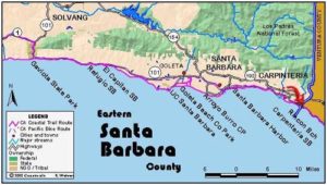
Legend: For details on the icons and trail colors, please click the legend icon on the map above.

Layers: Other layers are available. See the California Coastal Commission and Coastal Conservancy Completed Sections layer for the official completed trail segments. (About progress on the trail completion project.)
Santa Barbara Section 12
Carpinteria State Beach to Rincon Beach County Park
This final Santa Barbara section offers a pleasant, diverse walk despite passing extensive oil drilling and storage facilities. The beach at Carpinteria is known as "the safest beach in California" because a shallow offshore shelf prevents rip currents and minimizes rogue waves. Beyond the state park, the CCT passes through City Bluffs Beach Park, recently purchased after a dogged fundraising effort by local coastal advocates saved the land from development. Beyond the oil drilling facilities, you'll pass through the California Seal Sanctuary, one of only four onshore harbor seal pupping areas in the state. Beyond that CCT follows a wild span of beach to Rincon Point, a Mecca for surfers, just short of the Ventura County line.
A village of the native Chumash people long occupied the banks of Carpinteria Creek near its mouth. When Spaniard Gaspar de Portola visited the site in 1769, he was so impressed by the Chumash boat building activities that he called the village La Carpinteria, Spanish for carpenter shop. The Chumash gathered planks from inland pine trees and hauled them to coastal villages where craftsmen would split them with whale-rib wedges that had abalone shell blades. They used plant fibers to sew the planks together, then caulked them against leakage with tar from local seeps. The Chumash used their boats to travel across the Santa Barbara Channel, a powerful testimony to their seaworthiness. On the Channel Islands they would hunt and fish, also trading with other Chumash villages there.
From the end of Linden Avenue, walk down to the tideline and turn left.
Follow the tideline of Carpinteria State Beach down the broad beach in front of the campground. Watch for tar balls on the beach that come from active tar seeps ahead. Pass the Palm Drive access to the State Beach around ¼ mile and continue east to cross the mouth of Carpinteria Creek at ⅜ mile.
Soon the beach narrows, with a low bluff above the strand being part of the state park campground. Pass active tar seeps in the low bluff along the narrowing beach from ½ to ¾ mile. Beyond ⅝ mile you may need to walk through the campground when the tide is high since the beach may be inundated. Continuing along the beach, the bluffs get higher.
When you reach a stairway near the eastern boundary of the state beach at ¾ mile, walk up the steps and turn right to follow the blufftop trail east, passing through mostly undeveloped City Bluffs Beach Park. At ⅞ mile the path dips through a gully with beach access, then returns to the blufftop to follow the bluff edge east. Around one mile you pass some picnic tables on a small point near a [ew scattered cypress trees on the blufftop.
CCT continues east on the blufftop path for about 400 feet beyond the point, then veers northeast to 1⅛ miles where it joins and follows an oil company service road east. Take the paved track and parking lot nearest the railroad tracks, the only way through. Pass the oil company pier by 1¼ miles and continue to the end of the parking lot.
Continue southeast on the dirt blufftop track. It soon returns to the bluff's edge, passing a sign about the harbor seal pupping area, the California Seal Sanctuary, on the beach below. That area of the beach is closed every year from December 1 until May 31 to allow the seals to breed and pup without interruption. You can watch the action from the blufftop.
CCT continues east on the blufftop trail for another J mil_. Before 1½ miles, you come to the first of two paths that descend to the beach. If your hike here isn't during the seal pupping season closure and it isn't high tide, you can descend this path to a rocky beach at 1½ miles. Walk the rocky beach around the point at 1⅝ miles, then follow the beach east, soon meeting the second path between blufftop and beach around 1 ¾ miles. Continue on down the mostly rocky beach, passing more tar seeps around 2 miles. The bluffs rise 120 feet on your left around 2¼ miles as you walk a beach of cobbles and sand. By 2½ miles the bluffs tower 160 feet overhead. After you pass some fine tidepools around 2¾ miles, the bluffs get lower and the beach becomes very wide as you head towards wooded Rincon Point.
By 3⅛ miles, where the bluffs rise only about 30 feet above the beach, you'll come to both gentle ramp and stairs rising to the parking lot for Rincon Beach County Park. If you're continuing down the coast, the next section starts here. If you left a vehicle at the Rincon Park lot, ascend to reach it before 3¼ miles. Day hikers might want to walk the ¼ mile to Rincon Point itself before turning back.
SUGGESTED ROUND TRIPS & LOOPS: Walk the beach from either end, up to 6½ miles round trip. Walk or bicycle the bluffs of City Bluffs Beach Park where small loops can be made between the shore and the train tracks.
Distance: 3⅛ miles (5.0 kilometers).
Open to: Hikers.
Surface: Beach, trail.
Access point: Carpinteria State Beach at Linden Avenue.
How to get there: Exit Highway 101 in Carpinteria east of Santa Barbara at Linden Avenue. Turn right and drive Linden to its end at the beach in .7 mile. (The main entrance to Carpinteria State Beach, where you enter the campground, is at the end of Palm Avenue four blocks south.)
Other access: City Bluffs Beach Park, the newly purchased public coastal land at Ballard Road, has an informal path to the CCT.
Difficulty: Easy
Elevation gain/loss: 50 feet+/60 feet-.
Cautions: Watch for tar balls on the beach. Stay out of the seal pupping area from December through March. Dogs OK on leash on the county beach. Dogs not allowed on state beach.
Further information: Carpinteria State Beach (805)684-2811, Rincon Beach County Park, (805)568-2460.
Facilities: Water, picnic tables, restrooms and phones at Carpinteria State Beach and Rincon Beach County Park, picnic tables at City Bluffs Beach Park.
Campgrounds: Carpinteria State Beach has 262 campsites.
Lodging: Carpinteria has ample accommodations from budget to deluxe.

Interested in contributing to this project?
Register to add new photos and information, update existing results and share your trip reports.