
Usage Notes

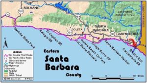
Legend: For details on the icons and trail colors, please click the legend icon on the map above.

Layers: Other layers are available. See the California Coastal Commission and Coastal Conservancy Completed Sections layer for the official completed trail segments. (About progress on the trail completion project.)
Santa Barbara Section 11
Lookout County Park to Carpinteria State Beach
This route follows an isolated beach at the base of high bluffs before entering the flat landscape of Carpinteria Valley where it follows the beach if tides allow, then the road shoulder briefly through the little settlement of Santa Claus Lane with its permanent Christmas facade. It continues on a path along the railroad tracks to get around Carpinteria Marsh, the oceanside mouth of which is generally impassable at its tide-scoured channel. The route then follows city streets back to the beach. If you start from the Lookout Park parking lot, you need to descend the paved trail ⅛ mile to the beach to join the CCT.
Summerland had the dubious distinction of having the first offshore oil drilling rig in the nation. Offshore drilling began here in 1896, and by 1906 more than 400 wells covered Summerland beaches. Then in 1958, the first modern oil rig on offshore state lands was built two miles out from Lookout Beach. In 1969, a rig five miles offshore had a blowout, causing a huge spill that blackened beaches all along the Santa Barbara coast, effectively closing them to public use for eight or nine months.
From the paved ramp at Lookout County Park, walk the beach east toward the high bluffs of Loon Point. Beyond ⅜ mile a seasonal creek has carved a canyon in the 50-foot bluffs, spanned by a railroad trestle. The bluffs resume as you walk down the beach. Around ⅞ mile the railroad veers away from the shore, with a volunteer coastal access path following the tracks to the Loon Point parking lot. CCT follows the narrow sandy beach east. As you approach Loon Point, the sand gives way to a rocky intertidal zone beyond 1¼ miles. The bluffs get lower as you near Loon Point, then they are bisected by Toro Canyon where another volunteer path ascends along the creek to the Loon Point lot on Padaro Lane ¼ mile north. Native sycamore and coast live oak line the stream up canyon, mingling with introduced cypress and eucalyptus trees that shelter monarch butterflies. Beds of giant kelp grow more than ½ mile offshore here.
After you round Loon Point at 1½ miles, continue along a meandering tideline of a mostly narrow beach below 40-foot bluffs. You begin to see houses atop the wooded bluffs beyond 2 miles. Soon the bluffs disappear, yielding to low marine terraces that support specialty crops like avocados and citrus. Beyond 2¼ miles the beach angles southeast past scattered beach houses in the community of Serena. If the tide is high, around 2⅜ miles you may need to detour inland to follow Padaro Lane. Otherwise continue along the beach crowded by houses, coming to riprap around 3 miles that may require scrambling at tides above +3.5 feet.
Beyond the rocks you can walk the beach to around 3⅜ miles before it ends at a wall of riprap shielding a private Arabesque house perched on a small point. Just before the beach ends, turn inland and walk northeast across the riprap and train tracks. Look for a path between the Padaro Beach Grill on the left and Santa Claus/Toyland on the right. It leads to Santa Claus Lane, where you turn right and walk past Toyland. At the end of this clapboard tourist Mecca, turn right and head south through bamboo to the railroad tracks. Turn left and follow the volunteer path beside the railroad right-of-way, a route frequently used by locals.
You reach a cross street, Estero Way, that crosses the tracks to enter the Carpinteria Marsh at 4¼ miles. Turn left and walk Estero Way briefly to Carpinteria Avenue, then turn right and follow this into town. Turn right on 7th Street at 4¾ miles and follow it southeast to Linden Avenue before 5¼ miles. Turn right on Linden and follow it to its end at the beach at 5⅝ miles where this section ends and the next one begins. Carpinteria City Beach extends west on your right and Carpinteria State Beach extends east.
ALTERNATE ROUTE: If the tide is higher than +3.0 feet, around 2⅜ miles you may need to detour inland to follow Padaro Lane to Santa Claus Lane.
SUGGESTED ROUND TRIPS & LOOPS: Walk east from Lookout Park for as long as you like. Or hike to the beach at Loon Point and hike west or east on the CCT.
Distance: 5⅝ miles (9.1 kilometers).
Open to: Hikers, dogs. Bicyclists on streets and path along tracks.
Surface: Beach, sidewalks, trail.
Access point: Lookout County Park.
How to get there: Exit Highway 101 at Summerland/Evans Avenue east of Santa Barbara. Go left, then left again on Evans, following it downhill to its end at Wallace Avenue opposite the Lookout County Park entrance.
Other access: Around Loon Point from Padaro Lane, either west along railroad tracks or south down Toro Canyon along its creek to Loon Point. From Santa Claus Lane, walk across railroad tracks and riprap to beach.
Difficulty: Easy
Elevation gain/loss: Negligible.
Cautions: Lookout Park is open 8 a.m. to dusk. The beach between Serena and Sandyland is passable at tides below +4.0 feet.
Further information: Lookout County Park (805)969-1720, or call Santa Barbara County Parks and Recreation (805)568-2460, Carpinteria State Beach (805)6842811, Carpinteria City Beach (805)684-5405 ext. 449.
Facilities: Lookout County Park and Carpinteria State Beach have water, picnic tables, restrooms and phones.
Campgrounds: Carpinteria State Beach has 262 campsites.
Lodging: Carpinteria has a variety of accommodations.
Points of Interest

In the News
Interested in contributing to this project?
Register to add new photos and information, update existing results and share your trip reports.