
Usage Notes

Legend: For details on the icons and trail colors, please click the legend icon on the map above.

Layers: Other layers are available. See the California Coastal Commission and Coastal Conservancy Completed Sections layer for the official completed trail segments. (About progress on the trail completion project.)
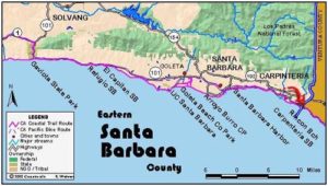
Santa Barbara Section 10
Stearns Wharf, Santa Barbara, to Lookout County Park
This section follows the beach for its entire route. In the event of rising tides, you'll find several escape routes. The hike passes two classic hotels, the Biltmore and the Miramar, and a row of attractive beach homes. The section begins at Stearns Wharf, which was damaged by fire in 1998. You can still stroll out on the wharf for a great view of the shoreline and city backed by the Santa Ynez Range. While there, visit the free Sea Center, which has exhibits on the marine aspects of the Channel Islands offshore, and the Nature Conservancy, with exhibits about several of its California preserves including Santa Cruz Island in the Channel group. You might also have a seafood meal or buy some fresh seafood at the open air market. The wharf is open 24 hours.
Stearns Wharf was originally constructed in 1872 when local commerce with the rest of the world was conducted largely by ship. When local lumber merchant J. P. Stearns completed the wharf, it was the longest pier between San Francisco and Los Angeles. For twenty years streetcars ran between the wharf and downtown. When the first restaurant was built on the wharf in 1941, it marked the end of the wharf's use for shipping and passenger traffic.
From the foot of the Wharf at the end of State Street, walk east along the beach or on the pedestrian walkway. Pass through mile-long Chase Palm Park, with a strip of lawn lined with tall palms. Beyond the park you reach East Beach, another Santa Barbara-style park with picnic tables, grills and a children's playground near the street and a gorgeous broad beach along the shore. After you pass the 1925-vintage Cabrillo Pavilion, the top of the beach is filled with volleyball courts, a popular local pastime.
At 1⅞ miles Cabrillo Boulevard turns inland, East Beach officially ends and the bluffs begin, soon rising 50 feet above the broad beach they shelter. Across the street here you'll find the Andree Clark Bird Refuge, with a paved bike path along its south and east shores. If the tide is above +2.5 feet, you need to cross the street and follow the bike path east, then follow Channel Drive to return to the CCT at Butterfly Beach.
[f the tide is below +2.5 feet, walk the beach east along the base of the bluffs. Around 2⅛ miles you pass a wonderfully comfortable rest spot at the base of the bluff with a rock perfectly contoured for two backs. Continue east along the narrowing beach beneath golden cliffs topped by cypresses and palms. As you approach the narrow point around 2⅜ miles, large stones litter the sandy beach. If tide and surf allow you around the point, the stones soon give way to a broadening beach at the base of descending bluffs.
After you pass a remnant seawall beyond 2½ miles, follow the broad beach below the bluffs to Butterfly Beach at 2¾ miles, passing the stairway to Channel Drive and Butterfly Lane. Walk the broad beach, also a popular spot, along bluffs that dip even lower, passing the stairs from the Biltmore Hotel around 3⅛ miles.
Beyond the resort, the beach swings out to a rounded point around 3⅜ miles. At the point's southernmost arc, the Surfrider Trail heads inland across the northwest corner of Hammonds Meadow, a 22-acre rolling grassland and natural area on the low bluff above the beach. Continue east along Hammonds Beach, crossing the mouth of Montecito Creek at 3⅝ miles. On the east side of the creek, the Bakewell Trail provides beach access from the end of Eucalyptus Lane. After Hammonds Beach, the low bluff up from the beach is lined with homes.
Where the coast veers north briefly around 4 miles, walk narrow Miramar Beach, shared with the Miramar Hotel across the railroad tracks. Continue past stately beachfront homes, crossing the mouth of Oak Creek at 4¼ miles, then San Ysidro Creek shortly beyond. The beach broadens heading for Fernald Point.
Cross the indistinct mouth of Romero Creek at Fernald Point at 4¾ miles. As you make the turn around the point, vistas expand to the high tan bluffs around Loon Point with the high peaks of Ventura County rising beyond. After crossing a low seawall at 4⅞ miles, walk the beach, passing the last beachfront house around 5⅛ miles. The beach narrows and turns east with the bluffs rising high above topped by Freeway 101. Follow seawalls protecting the tracks halfway up the sloping bluffs. When the second seawall ends at 5½ miles, you may need to scramble briefly over riprap or get wet along the tideline to reach Lookout Beach.
Follow a third seawall from 5⅝ to beyond 5¾ miles. By the time it ends near one more beachfront home, you're on the broad beach of Lookout County Park. Before 6 miles, watch for the paved trail climbing ⅛ mile from the beach to Lookout County Park's parking and picnic areas. The sloping path, lined by a chain link fence, marks this section's end and the start of Santa Barbara Section 11.
ALTERNATE ROUTE: At tides above +2.5 feet, you must leave CCT's main route at the east end of East Beach, cross Cabrillo Blvd. and head east on the bike path along the south boundary of Andree Clark Bird Refuge, then follow Channel Drive east and south to Butterfly Lane to descend the stairs and return to the CCT.
SUGGESTED ROUND TRIPS & LOOPS: Walk the beach from either end for as long as you like or tides will allow.
Distance: 6 miles (9.7kilometers).
Open to: Hikers, dogs on leash.
Surface: Beach.
Access point: Stearns Wharf.
How to get there: Exit Highway 101 in Santa Barbara onto Castillo Street and go south .4 mile to its end, then turn left on Cabrillo Blvd. and go east .4 mile to Stearns Wharf at the foot of State Street. (Downtown Santa Barbara is north on State Street.) You'll find limited parking on the wharf and hourly parking three blocks east at city lots on Cabrillo Blvd.
Other access: East Beach on Cabrillo Blvd., Butterfly Beach off Butterfly Lane, stairway at Biltmore Hotel, Hammonds Beach off Eucalyptus Lane, Miramar Beach in front of Miramar Resort Hotel on Jamison Lane.
Difficulty: Easy
Elevation gain/loss: Negligible.
Cautions: The tideline from the east end of East Beach to Butterfly Beach is only passable at tides of +2.5 feet or less.
Further information: Santa Barbara City Department of Parks and Recreation (805)564-5418, Lookout County Park (805)969-1720.
Facilities: West Beach, Palm Park, East Beach and Lookout County Park have restrooms, water, phones and picnic tables.
Campgrounds: Carpinteria State Beach, 12 miles east, has 262 campsites.
Lodging: Santa Barbara has many choices from budget to deluxe. In the latter category are two grand hotels adjacent to the CCT, the Four Seasons Biltmore and the Miramar Hotel. Banana Bungalow, (805)963-0154, is only seven blocks from the beach near Sterns Wharf.
Points of Interest

In the News
Interested in contributing to this project?
Register to add new photos and information, update existing results and share your trip reports.