
Usage Notes

Legend: For details on the icons and trail colors, please click the legend icon on the map above.

Layers: Other layers are available. See the California Coastal Commission and Coastal Conservancy Completed Sections layer for the official completed trail segments. (About progress on the trail completion project.)
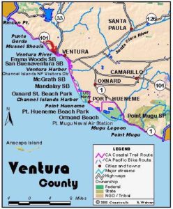
Ventura Section 1
Rincon Beach County Park to Faria Beach County Park
The first Ventura County CCT section begins at picturesque Rincon Point, passes the little settlement of La Conchita and historic oil wells, then takes to Old Pacific Coast Highway. Unfortunately, this section has perhaps the worst example of a damaged coastline because of the thoughtless and intense use of riprap to protect shoreline property from erosion. CalTrans, Ventura County and homeowners have dumped tons of huge boulders right into the surf and on the beach to build Highway 101 at the base of steep eroding coastal hills. For more about the negative effects of riprap, read The Case Against Shoreline Armoring.
The highway built right on the shoreline makes the first part of this section difficult. After leaving Rincon Point, you have three ways to make it to the Old Pacific Coast Highway at Sea Cliff. The route then becomes more pleasant and straightforward on its way to Ventura.
Before 1900 the Ventura-Santa Barbara stage followed the tideline along the coast here. Often the stage would have to wait for the tide to recede to get around Rincon Point.
To start this walk from Rincon Beach County Park, take the stairs or the ramp down to the beach. At most tides the route around Rincon Point is passable. If the beach is flooded, you will have to walk on the low riprap that lines the point to protect the houses. Off the point, surfers ride what they describe as one of the best winter breaks in the world, providing beautifully shaped waves and long rides. Just before the rocky point at ⅜ mile, cross Rincon Creek into Ventura County. Continue down the rocky shoreline. At the end of the row of houses before ¾ mile, a path descends from a parking lot. At extremely low tides you can continue on the sand at the base of the riprap. You can also rock hop on the large boulders when the ocean is calm, but to do so requires steady feet and good balance. The riprap route offers quieter but slower going than the highway.
If the beach or riprap look impassable or too difficult, take the path up to the parking lot. From there you can follow the bike lane down the highway. A third route, not recommended, follows the railroad tracks at the base of the hills to La Conchita, then follows a utility right-of-way from La Conchita to the end of Old Pacific Coast Highway near the Bush Oil Company. Whichever route you take, the goal remains to make it to Sea Cliff 5⅜ miles down the coast from Rincon Point. From there the route follows lightly traveled Old Pacific Coast Highway.
To walk the riprap or low tide beach, continue on the beach past the last house on Rincon Point to the riprap at ⅞ mile. If the route proves unsafe or uncomfortable after you get started, you can carefully climb up the rocks to the bike lane, but you would also need to climb over a fence. It would be better to decide early if the route is feasible so that you can return to Rincon Point and walk the bike path if necessary.
To get to the bike lane from Rincon Point, take the path next to the last house. Follow it to the parking lot, exit the lot on the entrance drive and walk up the access ramp to the highway and the bike lane. This section of highway, although not a freeway, is very busy with noisy and fast traffic.
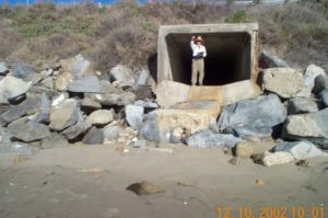
To get to the tracks, take Bates Road under the freeway and scale the embankment up to the tracks. Take the dirt track paralleling the tracks, then follow the street through La Conchita, then the utility road before reaching the end of Old Pacific Coast Highway where it dead ends about ¾ mile north of Sea Cliff. Follow Old Pacific Coast Highway under the freeway, then along the coast.
On both the recommended routes, you walk past houses on Punta Gorda at 3¼ miles. An oil pier marks the point. If you are scrambling on the rocks, you reach a narrow road around 4½ miles which tunnels under Highway 101 to Old Pacific Coast Highway, where you turn right. You can also continue on the rocks and pick up the Old Pacific Coast Highway at Sea Cliff. Whether you follow the rocks or the bike path, you reach Sea Cliff at 5⅜ miles.
From Sea Cliff walk the wide road shoulder past row of houses, or you can a instead walk in front of the houses at low tide until you get to Hobson County Park. Beginning at Hobson County Park at 5⅞ miles, the road parallels the surf atop the wicked looking riprap, so the bike path is the best choice. Around 6¼ miles you reach Rincon Parkway with RV campsites on the road shoulder. In summer and winter the road is lined bumper to bumper for more than a mile with large RVs. Rincon Parkway ends at Faria Beach County Park at 7¾ miles and so does this section.
SUGGESTED ROUND TRIPS AND LOOPS: You can explore the sandy Rincon Beach, then walk around Rincon Point to explore tidepools and watch the hot surfing action, 1½ miles round trip, or cut across the point by taking the path up to the two parking areas.
Distance: 7 to 7¾ miles (11.3 or 12.9 kilometers) depending on route.
Open to: Hikers. Bicyclists on most.
Surface: Beach, riprap, road, bike lane on highway shoulder.
Access point: Rincon Beach County Park.
How to get there: Take the Bates Road exit from Highway at the Santa Barbara/ Ventura County Line. Drive Bates Road to its end where free parking lies both on right and left at the entrance to a gated community.
Other access: Rincon Point, Hobson County Park, Faria Beach County Park.
Difficulty: Easy
Elevation gain/loss: 60 feet-. Modest gains and losses climbing riprap.
Cautions: Use extreme caution while walking the highway, climbing on riprap, or following the railroad right of way.
Further information: Rincon Beach County Park (805)568-2460, Faria Beach County Park and Hobson County Park (805)654-3951.
Facilities: Parking, restrooms, water, picnic tables, phone at Rincon Beach County Park. Restrooms, water, picnic tables at Faria Beach County Park.
Campgrounds: Hobson County Park has 31 sites and hot showers. Faria Beach County Park has 42 sites and hot showers. Carpinteria State Beach to the north has 262 campsites and hot showers.
Lodging: Carpinteria Valley has many rooms of all kinds. Mussel Shoals near La Conchita has the moderately priced Cliff House.
Points of Interest

In the News
Interested in contributing to this project?
Register to add new photos and information, update existing results and share your trip reports.