2003 Coastal Trail Expedition
Orchard Camp to Little Jackass Creek
June 22: Mendocino CountyOrchard Camp to Little Jackass Creek, 8 miles We are in the thick of the backpack portion of our trip now. This is serious work. There are two themes at play here: up and down or rather, up, up, up and down, down, down. Whereas during our first days’ backpacking, we had…
Read MoreChemise Mountain to Orchard Camp
June 21: Mendocino CountyChemise Mountain to Orchard Camp, 11.5 miles On a beautiful blue solstice day we hiked up Chemise Mountain. We began at Hidden Valley Trailhead near Nadelos Campground, winding our way up past two small hidden valleys, then up switchbacks for a time. We wound our way gently up the ridge, as wind swished…
Read MoreShipman Creek to Shelter Cove/Hidden Valley Trailhead
June 20: Humboldt CountyShipman Creek to Shelter Cove/Hidden Valley Trailhead. 6.2 miles to Shelter Cove, 10.4 miles total to Hidden Valley We had a fairly discreet skunk visit us in the night. After breakfast we begin again our backpack accompanied by bear tracks in the sands. A mile or so out of camp, we come across…
Read MoreSpanish Creek to Shipman Creek
June 19: Humboldt CountySpanish Creek to Shipman Creek, 8.8 miles As we came into camp yesterday, two glass fishing-net floats were found on the beach. Most of the floats we’ve found so far are plastic: red, yellow, black, pink; at a distance they look like bowling balls with little handles. It is indeed something to be…
Read MoreMouth of the Mattole to Spanish Creek
June 18: Humboldt CountyMouth of the Mattole to Spanish Creek. 10.2 miles “Life would be worsity if we don’t respect the ocean’s diversity.” Sign at the campground at the mouth of the Mattole. At a low enough tide to expose the sea palms on the rocks flanking the beach, we began the backpack portion of…
Read MoreA. W. Way County Park, layover day
June 17: Humboldt County A. W. Way County Park, layover day Our first full layover day was a welcome respite from the daily routine that has developed for all our walking days. Our main morning task was to partake of a fine breakfast prepared by Berti and Jo – scrambled eggs, raisin and walnut toast,…
Read MoreDevil’s Gate to the mouth of the Mattole
June 16: Humboldt CountyDevil’s Gate to the mouth of the Mattole 8.9 miles At 9 AM we arrived back at Devils Gate and met our guide for the day. Bill McKenzie, an accountant from Eureka, started off by giving us a choice between road walking along the Mattole Road or beach waking. We split into…
Read MoreGuthrie Creek Trailhead to Devil’s Gate
June 15: Humboldt County Guthrie Creek Trailhead to Devil’s Gate. 10.8 miles We did it! We got around False Cape. The entire schedule up to this point has pivoted on this day. To get around False Cape you need to have a low tide, the lowest minus tide you can. Our low – a minus 1.95…
Read MoreTable Bluff Beach to Guthrie Creek Trailhead. 13.3 miles
June 14: Humboldt County Table Bluff Beach to Guthrie Creek Trailhead. 13.3 miles We left the relative warmth of our camp at the Ferndale Fairgrounds and met our day leader, Robert Smoak, in the crisp, breezy fog at Table Bluff Beach. Even though the tide had reached its low 2 ½ hours before, we still had…
Read MoreSouth Spit of Humboldt Harbor to Table Bluff Beach. 5.2 miles
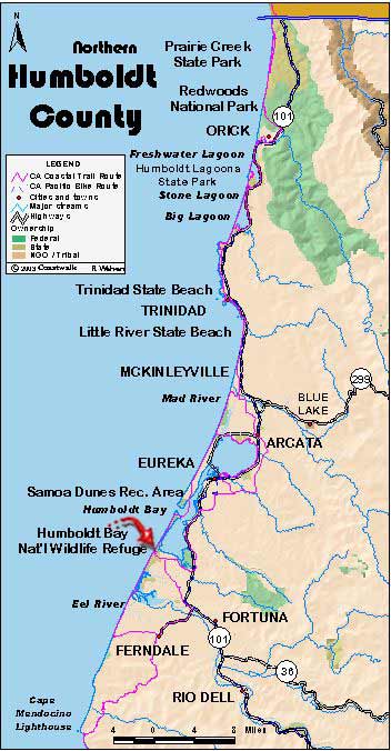
June 13: Humboldt CountySouth Spit of Humboldt Harbor to Table Bluff Beach. 5.2 miles At noon the group assembled at the Adorni Center in downtown Eureka following our overnight home stays. With everyone washed and all our clothing laundered, we were hardly recognizable to each other. After saying our goodbyes and giving our thanks to…
Read More


