
Usage Notes

Legend: For details on the icons and trail colors, please click the legend icon on the map above.

Layers: Other layers are available. See the California Coastal Commission and Coastal Conservancy Completed Sections layer for the official completed trail segments. (About progress on the trail completion project.)
Los Angeles Section 5
Topanga County Beach to Santa Monica Pier
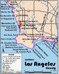
From Topanga County Beach to Torrance Beach more than 20 miles distant, the character of the Los Angeles coastline changes dramatically from the mountainous Malibu coast. While in Malibu development spreads out somewhat, intensely developed Santa Monica Bay from Topanga County Beach to Torrance Beach features a row of distinctive beach cities. Even more contrasting, access to the Malibu coast remains difficult in many places because of beachfront development and bluffs, while Santa Monica Bay flaunts nearly all sandy public beach for the entire 20 miles. It's paradise for beach hungry residents. Notably, a multi-use bike path covers the entire distance.
Will Rogers State Historic Park nestles in the hills about 2 miles inland from Will Rogers State Beach, part of this section. The garrulous Rogers moved there in 1928 with his wife and three kids, staying until his death in 1935. The 186 acres, the house and horse facilities became a park in 1944. Activities include picnicking, touring the house full of Rogers artifacts, horseback riding and hiking. The southern terminus of the Santa Monica Mountains Backbone Trail is in the park. You have a choice here of either cycling the entire length in an easy day or walking the beach or the bike path in several days. The walk rewards you with wild and crazy Venice Beach, and several other beach towns, five piers, a marina and a harbor. You get a sense of the enormity of Los Angeles after seeing the massive Hyperion Water Treatment Plant and hearing and seeing passenger airliners taking off over Dockweiler Beach from Los Angeles International Airport every minute all day long.
From the front of the Topanga County Beach lifeguard station, walk down the sandy beach to its end at riprap protecting a building at ⅜ mile. Walk up and around the building, then return to the beach at ½ mile. Will Rogers State Beach begins here, extending down the coast for 3 miles. The sandy beach starts out quite narrow on the north end with the highway not far from the tideline and quite distracting. The beach broadens from 1⅝ miles to 2 miles where you come to the hotspot Gladstone's Restaurant at 2 miles. Take the concrete ramp up the riprap in front of the building to the parking lot, walk through the lot and take stairs back to the beach before 2¼ miles. Continue along broad beach past the a end of Sunset Blvd. Then the beach narrows again until around 2⅜ miles. From there you walk a broad beach along the shore of Santa Monica Bay.
Farther down Will Rogers State Beach, you reach the beginning of the South Bay Bicycle Trail in the parking area at 3⅛ miles. From here to Torrance Beach, you can walk the paved path, dodging bikes and inline skaters, or wade through the sand down by the surf. In addition, in Santa Monica and several other beach communities, there is also a promenade adjacent to the sand.
If you continue along the beach, it becomes very broad by 3¼ miles, where Temescal Canyon Park lies across the Pacific Coast Highway. Follow the tideline of the broad beach. At 4⅜ miles the Backbone Trail (see Ventura Section 6A), an alternate CCT High Route, returns to the beach via Chatauqua Blvd., which ends opposite the beach beside the mouth of Santa Monica Canyon.
Now you have less than 2 miles remaining to the Santa Monica Pier. By 4⅝ miles Will Rogers State Beach ends and Santa Monica State Beach begins. Soon buildings line the top of the broad beach, with Palisades Park hiding atop the 100-foot-high bluffs beyond the highway. The closer you get to the looming pier, the busier the beach gets, especially in the summer. Millions of people of every cultural and ethnic stripe visit this beach and pier every year. By 5½ miles the Promenade runs along the top of the beach between the tideline and the Pacific Coast Highway. By 6⅛ miles the broad beach is 1/5 mile across. Whether you are traveling via beach or bike path, the section ends at 6¼ miles at the stairs to the pier. Consider climbing the stairs for a tour of the Santa Monica Pier with its old fashioned carousel, amusement park with giant ferris wheel, and enough fast food stands and souvenir shops to feed and entertain the legions of beach goers and empty their wallets.
SUGGESTED LOOPS AND ROUND TRIPS: Temescal Canyon Park offers one of the few trail connections to the Santa Monica Mountains backcountry. It's about 1½ miles up through the grassy picnic grounds to Temescal Gateway Park. From here the Temescal Canyon and Ridge Trails take you to the Backbone Trail inland about 8 miles from the coast.
Will Rogers State Historic Park warrants a visit and can be found by driving or walking up Chatauqua Blvd. in Santa Monica Canyon to Sunset Blvd. and the entrance about 2 miles inland. Several short trails in the park lead to the south end of the Backbone Trail. For the Backbone Trail, see Ventura Section 6A.
Distance: 6¼ miles (10.1 kilometers).
Open to: Hikers. Bicyclists on most.
Surface: Beach or paved multi-use trail.
Access point: Topanga County Beach.
How to get there: Topanga County Beach is at 18500 Pacific Coast Highway (Highway 1) at the east end of the city of Malibu and just west of Topanga Canyon Boulevard.
Other access: Almost the entire route is accessible from Pacific Coast Highway
Difficulty: Easy
Elevation gain/loss: Negligible.
Cautions: None.
Further information: For Topanga County Beach, call the Los Angeles County Lifeguard Service, Northern Section (310)457-9891. For Will Rogers State Beach, call the Los Angeles County Department of Beaches and Harbors (310)305-9503. For Santa Monica State Beach, call the Los Angeles County Lifeguard Service, Central Section (310)394-3264.
Facilities: Urban amenities exist at both ends of this hike and along the route.
Campgrounds:
Lodging: Motels and hotels abound in Pacific Palisades and Santa Monica. Santa Monica Hostel is in downtown a few blocks from the beach (310)393-9913.
Points of Interest

In the News

Interested in contributing to this project?
Register to add new photos and information, update existing results and share your trip reports.