
Usage Notes

Legend: For details on the icons and trail colors, please click the legend icon on the map above.

Layers: Other layers are available. See the California Coastal Commission and Coastal Conservancy Completed Sections layer for the official completed trail segments. (About progress on the trail completion project.)
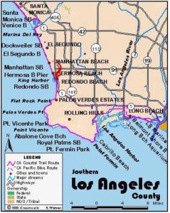
Los Angeles Section 6
Santa Monica Pier to Manhattan Beach Pier
This lengthy section lends itself to bike riding, or to a good one-way hiking works out with a return bus ride back to your car. Much of the route can be done either on the beach along the firmer wet sand at the shoreline, or you can walk the bike path with the awareness that bikes and inline skates rule, or you might want to do some of both to get the real variety and interest of this walk.
The hike starts at the Santa Monica Pier, in a way an extension of downtown Santa Monica. You might take a look at Santa Monica Pier with its old time carousel and amusement park, funky arcade games, and fast food joints serving the likes of corndogs and cotton candy. Grassy Palisades Park north of the pier and Crescent Bay Park south occupy the bluff overlooking the beach. Across Ocean Avenue from the parks sits classic downtown Santa Monica, an older southern California city enjoying unprecedented renewal. Although the January 1994 Northridge earthquake epicenter was miles away, many older downtown buildings were damaged and now have been repaired to their striking original opulence.
After a walk on the pier, head on down the beach toward Manhattan Beach.
The most interesting route for the first few miles follows the promenade along the beachfront businesses. You can also walk the wide sandy beach.
You reach Venice Beach at 1⅜ miles. Venice may be one of the most unusual towns anywhere, even along the California coast. Ocean Front Walk is home to a myriad of tourist businesses and a range of street people and vendors from new age spiritualists to cutting edge artists (or so it may seem to the gullible tourists) to beyond-hope bums, winos and panhandlers. Interspersed into this mix are body builders at a famous location known as Muscle Beach (located just south of the Santa Monica Pier, while a newer one is in Venice), girls on skates and barely in bikinis, and joggers taking a break from the office. A good dose of uncomprehending rubbernecking tourists and a contingent of totally incomprehensible yet interesting locals populate the sidelines. If you are a tourist and want to blend in, just act crazy!
A long history of incomprehensibility characterizes Venice. Conceived by entrepreneur Abbot Kinney, he thought he would build a town just like the famous Venice, Italy. In 1900 he dug canals and brought gondolas and gondoliers from Italy to help sell the canal-side lots. When that had less than the desired effect, Kinney built an amusement park, wildly popular in the 1910s. It all failed after Kinney's death in 1920, primarily due to an inadequate sewage system. After filling in most of the canals, oil was discovered in Venice. Over the years Venice changed but stayed the unique place it started out to be. Now the remaining canals are lined with Kinney's original dream houses. Inland a few blocks you can take the Canal Walk between Rose Avenue and Washington Blvd. passing well tended and eclectic residences.
Ocean Front Walk ends at 2⅛ miles. The bike path winding through the sand continues. You reach Venice Pier at 2¾ miles. From here you begin the walk around Marina Del Rey, a wealthy counterpart to Venice with its 6000 boat slips and multitude of moderate to upscale restaurants. From the pier, walk up the sidewalk of Washington Blvd. At 3⅞ miles watch for Mildred Avenue intersecting Washington from the left. Follow the bike path as it turns right into Admiralty Park. Walk through the park and follow the bike path across Admiralty Way. The path is painted on the library and marina parking lots. Turn right after crossing through a grassy area adjacent to Chace Park and either walk the sidewalk or stroll by the marina businesses.
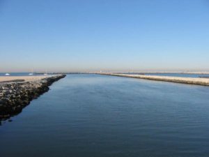
At the end of the street at 5¾ miles, the bike path continues on the Ballona Creek jetty. Cross Ballona Creek on a bridge at 6⅜ and enter Playa del Rey, where you might consider an interesting side trip. If you go left at the end of the bridge and walk inland along nearby streets, you can view a remnant of what used to be thousands of acres of marine estuary backed up against the beach. The Ballona wetlands and the adjacent Hughes Aircraft property are a battleground facing off environmentalists who want to save the tiny fraction of wetlands left in Los Angeles and those who want to develop it.
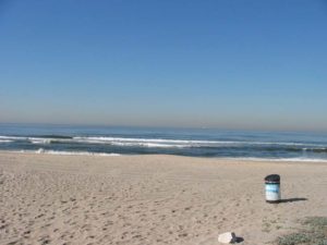
The CCT's route from the bridge heads toward the beach. Again the choice is between the bike path and the sand. At 7¾ miles you enter Dockweiler State Beach. This wide beach is lightly used compared to the rest of L.A.'s beaches because it lies directly under the departure flight path for Los Angeles International Airport. Hundreds of flights a day roar a few hundred feet overhead, drowning out every other sound and dousing everything with jet fuel fumes. The high dunes across the street from the beach used to be a housing tract that became unlivable as the jets got ever bigger and more numerous. Now a few endangered species make this dune environment home. A small band of conservationists wear ear protection when they work here trying to restore the dunes.
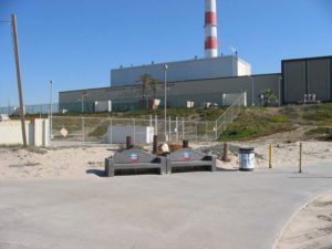
Farther down the beach past the jet noise, you come to Dockweiler Beach RV Park, a state park unit, before 9¼ miles. Continue down the beach past the looming, gigantic Hyperion Sewage Treatment Plant, which dominates the eastern skyline. The beach and bike path continue along very wide El Segundo Beach, then El Porto Beach, skirting an industrial area.
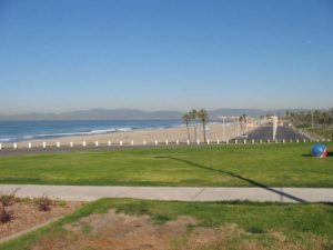
Cross into Manhattan Beach at 11⅜ miles, where low hills blanketed with residences rise to the east. Follow the broad, pleasant and long beach until you reach the Manhattan Beach Pier and section's end at 13 miles.
SUGGESTED ROUND TRIPS AND LOOPS: Take your choice of long or short beach walks, a walk into downtown Santa Monica and the pier, or check out the wild and wacky Ocean Front Walk in Venice.
For a 3-mile loop, take Ocean Front Walk and the beachfront between Rose Avenue and Washington Blvd. from either end, then cut inland a few blocks and take the Canal Walk and Main Street back in the direction you came.
Distance: 13 miles (20.9 kilometers).
Open to: Hikers. Bicyclists on bike path.
Surface: Beach, promenade, paved bike path.
Access point: Santa Monica Pier.
How to get there: The Santa Monica Freeway (I-10) ends in Santa Monica near the pier. The Santa Monica Pier is seaward of the corner of Ocean Avenue and Colorado Avenue adjacent to downtown Santa Monica.
Other access: Anywhere on the route.
Difficulty: Easy
Elevation gain/loss: Negligible.
Cautions:
Further information: For Santa Monica State Beach and Venice Beach, call the Los Angeles County Lifeguard Service, Central Section (310)394-3264. For Dockweiler State Beach and Manhattan County Beach, call the Los Angeles County Lifeguard Service, Southern Section (310)832-1179.
Facilities: Urban amenities abound along much of the route.
Campgrounds: Dockweiler State Beach RV Park near the L.A. Airport flight path has RV spaces only. Tent spaces are a rarity in Los Angeles. To find tent camping, one needs a car to get the nearest choices, two RV Parks near Disneyland that allow tents (about 50 miles, reservations advisable)-Travelers World RV Park (714)991-0100 and C.C. Camperland (714)750-6747.
Lodging: Abundant choices range from luxurious to basic. In the basic category, try the Venice Beach Hotel, just a bit fancier than hostel, with private rooms. In the moderate range three blocks from Venice Pier, try the Inn at Venice Beach. Santa Monica Hostel (310)393-9913 is a few blocks from the Santa Monica Pier. Venice has the Hostel California (310)305-0250 about 15 minutes walk from the beach. The small Marina Hostel (310)301-3983 is in Marina del Rey.
Points of Interest

In the News
Interested in contributing to this project?
Register to add new photos and information, update existing results and share your trip reports.