
Usage Notes

Legend: For details on the icons and trail colors, please click the legend icon on the map above.

Layers: Other layers are available. See the California Coastal Commission and Coastal Conservancy Completed Sections layer for the official completed trail segments. (About progress on the trail completion project.)
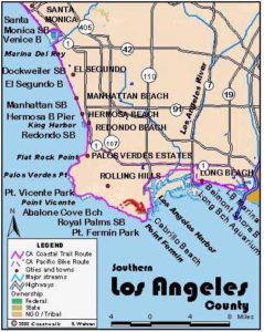
Los Angeles Section 9
Point Vicente to Royal Palms State Beach
This middle section of the three Palos Verdes Peninsula sections offers even more diversity than the previous one. The route explores secluded coves, passes near the dramatic Wayfarers' Chapel, crosses major active landslide, and ends at the site of a hotel claimed by the ocean many years ago.
Consider a visit to the Point Vicente Interpretive Center where you'll find displays on the marine life, geology, history, plants and animals of the Palos Verdes Peninsula. The center also has exhibits on the native Gabrielino people and culture which thrived here before white settlement, plus a big relief map of the area.
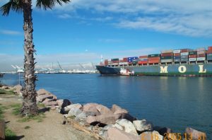
After taking a look at the Point Vicente Interpretive Center, spotting a whale, a or buying a gift, walk up the driveway to the bike lane along Palos Verdes Drive West. To the right Point Vicente Lighthouse, completed in 1926, still sends a light seaward to warn off ships but is closed to the public. Walk south past the Point Vicente Fishing Access at ½ mile where a side trail leads steeply down to the rocky shoreline. Continue along the bike lane, at 1¼ miles passing the entrance to the defunct Marineland atop Long Point. The aquarium, built in 1954, was doomed because of its remoteness, aging facilities, and competition from more modern aquariums and amusement parks. The land lies mostly empty now, its future uncertain. Continue along the bike lane beside the road to Abalone Cove Shoreline Preserve at 2 miles.
About ⅝ mile before Abalone Cove, consider a detour down residential streets to Vanderlip Park where a ⅜ mile blufftop path in front of some houses offers a look at the tidal rocks below, but little else. To do it, go right on Seaward Drive, right on Beachview Drive, left on Nantasket Drive, then follow the utility driveway to the bluff. Make a left onto the path which ends at a fence after ⅜ mile. Take the path left through the empty lot to Coastsite Drive, jog left on Beachview Drive and right on Seahill Drive which ends at Palos Verdes Drive South. Turn right to continue the main CCT route.
At Abalone Cove Shoreline Preserve, walk through the parking lot down to the low fence along the bluff's edge. As you descend you might glimpse the unique, beautiful Wayfarers' Chapel up on the hill above Palos Verdes Drive. Follow the fence to an opening at the corner where the fence turns inland. Take the path down the bluff through thick vegetation to an asphalt road and turn right. The road ends at a small building on the cove. Walk around the building and onto the beach to walk the rocky shore to the cliff of Portuguese Point at 2¾ miles. From the small deck with an old rock enclosure, take the gravel road uphill to the top of Portuguese Point. You can take a short detour out onto Portuguese Point for a look at Sacred Cove and Inspiration Point to the south, or simply continue along the road as it contours around the hill and ends at Palos Verdes Drive South at 3⅛ miles.
Walk the bike lane along the road, heading south beside a big pipeline.
Shortly you come to one of the most striking geologic features anywhere along the CCT. The road suddenly takes a severe dip just after a traffic warning sign. The dip marks the edge of the oldest active landslide on the planet, the Portuguese Bend landslide. Above the road, the gated community of Portuguese Bend, located on the edge of a bowl shaped canyon, sits perched in the slide zone. In the 1950s after numerous houses were constructed, the land suddenly started sliding toward the sea at a rate of up to six inches a day. Many houses were destroyed, but some survive by keeping them propped up on adjustable house mover cribbings as they move. The slide slowed somewhat in recent years with engineered fixes, yet some of the houses still moved as much as 600 feet over time while remaining occupied. Against the odds the owners keep the houses intact and continue to defend this horsey enclave against the inevitable sliding. A few hundred feet past the gated Peppertree Drive, the main CCT route turns right on a dirt road. A small sign marks it as an archery range and indicates if the range is in use. If in use, you can still enter but should stay on the road. The high route along Palos Verdes Drive South is described in Alternate Route below. The road cuts down through the jumbled, moving earth. Just after starting down it, you'll see two houses by the road that used to be on the other side of Palos Verdes Drive. As the earth moved, dragging the highway and houses with it, the road was straightened, leaving the houses downhill from the road on their slow descent to the sea.
Past the archery range at the end of the road, take the rough path down to the beach at 4 miles. From here you can follow the tideline below the slide. In calm weather and during all but the highest tides, the CCT follows the tideline all the way to Royal Palms State Beach. Walk the long sweeping beach in front of an exclusive beach club (you're out of the slide zone now). Then follow the tideline beneath 200-foot cliffs out around Half-Way Point, rounding the point at 5½ miles. If you need it, there's an escape trail just beyond the point that climbs to a road ascending to Palos Verdes Drive.
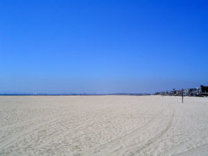
Continue rock hopping along the scenic shore at the base of more towering cliffs. The cliffs reach their highest extreme around 6⅜ miles. Continuing along the rocky tidal zone, you reach tall palm trees, then picnic tables, restrooms and a parking lot at the end of this section's hike at 7¼ miles. Look around the area to find the remains of the Royal Palms Hotel, built in 1883 to take advantage of a natural hot sulfur spring. Earthquakes reduced the flow of hot water, sO the hotel closed and was left to be destroyed by storms in the 1920s.
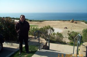
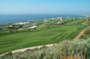
ALTERNATE ROUTE: From the archery range road, continue on Palos Verdes Drive South past the Portuguese Bend Club gated community to Conqueror Drive around 5 miles. From here you look down on a huge golf course and residential development being built as this book went to press. Turn right onto the new access path and follow it down to the bluff. Take any of several trails down to the beach. If you want to minimize the rock hopping, stay on the bluff trail until it drops into a big open valley with a mobile home park on the far side. Look for a steep trail and take it down to the beach. From here it is about one mile on tidal rocks to Royal Palms State Beach at 7¼ miles.
SUGGESTED ROUND TRIPS AND LOOPS: From the Ocean Trails Golf Course look inland for a huge bare cliff, once a bentonite quarry. The bowl beneath the cliff has naturalized into a special native habitat. To see it, go up Forrestal Drive on the other side of Palos Verdes Drive from the golf course entrance. To get to the cliff's base for fossils and crystals, go straight past the barricade. The Discovery Room in the community center to the left is also worthwhile.
Consider visiting the Wayfarers Chapel above Abalone Cove. The unique structure, designed by Lloyd Wright (Frank's son), is open daily from 11am to 4 pm.
Distance: 7¼ miles (11.7 kilometers).
Open to: Hikers. Bicyclists on streets and new development trails.
Surface: Beach, trail, road shoulder, bike path.
Access point: Point Vicente Interpretive Center.
How to get there: From Highway in Torrance, take Hawthorne Blvd. (N7) south to its end at Palos Verdes Drive West in the city of Rancho Palos Verdes. Turn left on Palos Verdes Drive West and go .25 mile to the Point Vicente Interpretive Center.
Other access: Point Vicente Fishing Access, Abalone Cove Shoreline Preserve, archery range access road, Ocean Trails Golf Club.
Difficulty: Moderate
Elevation gain/loss: Tidal Route, 300 feet+/440 feet-. High route, 400 feet+/ 540 feet-.
Cautions: The tidal route is mostly cobble, rock and boulder hopping.
Further information: For Point Vicente Fishing Access, Abalone Cove Shoreline Park, and Royal Palms State Beach, call the Los Angeles County Lifeguard Service, Southern Section (310)832-1179, City of Rancho Palos Verdes (310)544-5260.
Facilities: Point Vicente Interpretive Center, Ocean Trails Golf Club, Abalone Cove Shoreline Preserve and Royal Palms State Beach have restrooms, water, picnic tables and parking.
Campgrounds:
Lodging: Redondo Beach and San Pedro have motels and hotels. Los Angeles South Bay Hostel (310)831-8109 is in San Pedro.
Points of Interest
In the News
Interested in contributing to this project?
Register to add new photos and information, update existing results and share your trip reports.