
Usage Notes

Legend: For details on the icons and trail colors, please click the legend icon on the map above.

Layers: Other layers are available. See the California Coastal Commission and Coastal Conservancy Completed Sections layer for the official completed trail segments. (About progress on the trail completion project.)
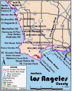
Los Angeles Section 10
Royal Palm State Beach to Cabrillo Marine Aquarium
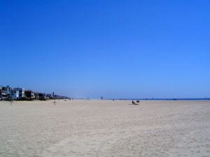
From the rugged shore of the Palos Verdes Peninsula to the Pacific edge of the city of Los Angeles represented by the port city of San Pedro, this section has much to offer along and near the route. Highlights include a Victorian lighthouse in a pretty park, a marine aquarium, and an apocalyptic view of the possible future of much of the California coastline. Two routes are offered: a tidal route that runs most of the way, and a sidewalk route preferable during high tides and/or bad weather.
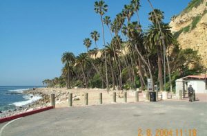
For the sidewalk route, walk up the Royal Palm State Beach entrance road to Paseo Del Mar, turn right and walk along Paseo Del Mar's sidewalk to Point Fermin Park. You'll recognize the park by the abundance of tall palm trees at one mile. The tidal route ascends the bluff adjacent to the residential area where the park begins.
To take the more adventurous and ½-mile longer tidal route, walk through the Royal Palm State Beach parking lot at the base of the cliffs, then continue on the rocks at the tideline. Watch for the swimming pool foundations awash in the shallow water just off the beach. After rounding a small cove, walk around rugged White Point at ⅝ mile and come to a wide path going up to the bluff from White Point Beach. You can exit the beach here, but the CCT tidal route continues on the rocks at the base of 120-foot cliffs.
At 1½ miles watch for the first of the palm trees of Point Fermin Park. They mark the path you climb to its top to meet the high route beside Paseo del Mar. Point Fermin juts prominently into the sea ahead. Although it is possible to make it around the point at low tide, it's a rough proposition and not recommended. If you elect to try it, scramble on the rocks around the point, then take one of several informal paths up to the park.
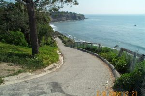
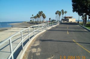
After climbing the path up to the bluff, turn right and walk east through narrow Point Fermin Park, hemmed in by house-lined Paseo del Mar above and the sea cliff below. Soon Paseo del Mar and the vertical cliff converge. The CCT takes to the road's sidewalk along the edge of the eroding cliff. You reach the larger part of verdant Point Fermin Park at 2¼ miles.
Take the park path along the cliff, guarded by a railing, to the elaborate Victorian building of the retired Point Fermin Lighthouse at 2½ miles. It was built in 1874 not many years after Los Angeles Harbor began to develop, but long before the container ports and cruise ships of today's massive harbor. After the lighthouse ceased operation in 1941, it was used as a residence until the late 1960s when the Coast Guard considered tearing it down. Alarmed local residents came to the rescue, saving and refurbishing the structure. The house is a park employee residence closed to the public, so you can only inspect it from behind the fence.
Before continuing on the main route, take a brief side trip to look at Sunken City-the past and possibly the future of the coastline eroding, sinking, slumping and eventually disappearing. Follow the walkway past the lighthouse to the imposing gray metal fence designed more as warning than as a barrier to keep people out. Step around the end of the fence at bluff's edge and walk out along the bluff. This was once part of Point Fermin Park and a residential area. In 1929 six acres of land started slipping, leaving the place today only a jumble of large blocks of earth and slabs of street and sidewalks tilted in all directions. It's reminiscent of the last scene in the movie Planet of the Apes with the Statue of Liberty buried up to its neck on a sandy beach. It demonstrates the foolhardy nature of building on the edge of a naturally eroding and unstoppable shoreline.
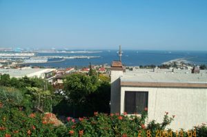
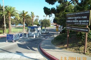
After the side trip, return to the lighthouse and walk north up to Gaffey Street directly inland where CCT follows sidewalks through a residential area. After a quarter block on Gaffey Street, go right on Shepard Street, left on Bluff Place, then straight on White Drive. Turn right on Oliver Vickery Circle at 3¾ miles and enter Cabrillo City Beach Park. After the entrance station, turn left and walk through the picnic area and over to the front of the Cabrillo Marine Aquarium at 4 miles where this section ends.
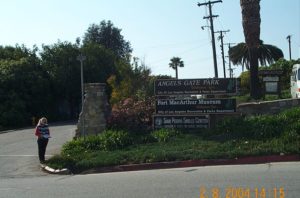
SUGGESTED ROUND TRIPS AND LOOPS: Walk up Gaffey Street, then go left on 36th Street to Angels Gate Park. The park features the massive Korean Friendship Bell, the Marine Mammal Care Center and the Fort MacArthur Military Museum. The Marine Mammal Care Center is open during regular business hours for self-guided tours. The museum preserves an intact coastal battery with all the equipment in place except for the huge disappearing guns which were cut up for scrap after World War II.
Distance: 4 miles for tidal route, 3½ miles for sidewalk route (6.4 or 5.6 kilometers).
Open to: Hikers. Bicyclists on street.
Surface: Beach, sidewalk.
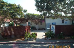
Access point: Royal Palms State Beach.
How to get there: Take Western Avenue/Highway 213 south to its end. Go left on Paseo del Mar for .25 mile, turn right and follow Kay Fiorentino Drive to the beach. Or, from San Pedro follow Paseo del Mar for 2 miles from the Point Fermin Lighthouse, then go left on Kay Fiorentino Drive to the beach.
Other access: Point Fermin Park, White Point access path.
Difficulty: Easy
Elevation gain/loss: 120 feet+/100 feet-.
Cautions: Parks close at sunset. Use caution on tidal rocks.
Further information: For parks and beaches in this section, contact the Los Angeles County Lifeguard Service, Southern Section (310)832-1179.
Facilities: Water, restrooms, picnic tables at Royal Palms State Beach, Point Fermin Park and Cabrillo City Beach.
Campgrounds:
Lodging: San Pedro has an abundance of motels and hotels. Los Angeles South Bay Hostel (310)831-8109 is in San Pedro's Angels Gate Park, 6 blocks up Gaffey Street from Point Fermin Park.
Points of Interest

In the News
Interested in contributing to this project?
Register to add new photos and information, update existing results and share your trip reports.