
Usage Notes

Legend: For details on the icons and trail colors, please click the legend icon on the map above.

Layers: Other layers are available. See the California Coastal Commission and Coastal Conservancy Completed Sections layer for the official completed trail segments. (About progress on the trail completion project.)
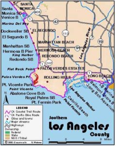
Los Angeles Section 8
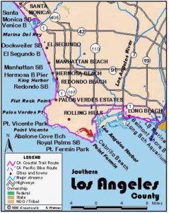
Torrance County Beach to Point Vicente
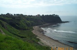
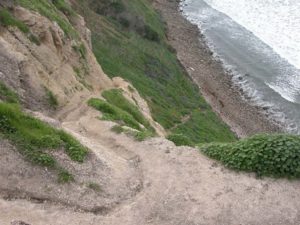
Palos Verdes Peninsula rises steeply from the sea with cliffs as high as 300 feet. Steep terrain and winding roads isolate the peninsula from the rest of greater Los Angeles, placing it far from the convenience of the freeway system so heavily used by the populace. The steep hills, now relatively well developed with expensive homes and gated neighborhoods, consist of a series of thirteen marine terraces indicating that both the sea and the land have risen many times over millions of years. The terraces indicate the old shoreline sea beds. The youngest terrace can be seen as tidal flats being formed by waves.
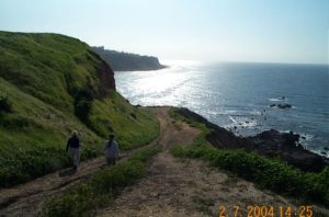
In geologic time the peninsula was only recently an offshore island like Catalina is today. Sediments from the surrounding mountains filled the channel, what is now the Los Angeles Basin, with alluvium up to 20,000 feet deep. Remarkably, parts of the peninsula continue to slide toward the sea, taking houses and roads and leaving tangled landscapes like "sunken city" and Portuguese Bend. The first of the three adventurous Palos Verdes Peninsula sections offers two routes. The bluff route is an easy footpath affording views of the tidal rocks and ocean far below. On the alternate tidal route the walker will encounter rocks rather than sand to walk on and experience the rugged nature of the shoreline at the base of steep cliffs.
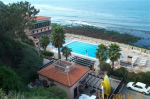
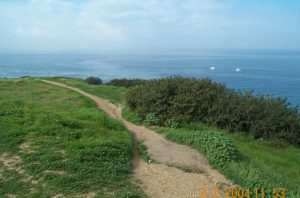
From Torrance County Beach at the end of the South Bay Bicycle Trail, walk south toward the cliffs where the sand gives way to rock. You can usually make it around the small point to Malaga Cove at most tides in calm weather. At 1⅛ miles, before you come to the Palos Verdes Beach and Athletic Club, a trail climbs to a parking area. You need to make a choice of routes here. To do the low tide walk described in Alternate Route below, continue on the rocks from here. The high route and main CCT route follows the trail up the bluff, then follows the path heading west along the ocean side of Paseo del Mar. Much of the bluff edge is developed. Follow the path as it meanders along undeveloped portions of the bluff and then onto the street in front of upscale homes and back to the bluff. Stay on the blufftop and in front of the houses on Paseo del Mar. On clear days spectacular views include a sweep of ocean and shoreline from Santa Monica Bay to Malibu. Beyond two miles Paseo del Mar passes Flat Rock Point, then swings inland and ends at Palos Verdes Drive West. Turn right and follow Palos Verdes Drive West for about ⅞ mile to Paseo del Mar West at 2⅞ miles. Turn right and walk along the bluff paralleling Paseo del Mar West. Where houses stand on the bluff in places you need to wind back and forth between the bluff and the street. Catalina Island rises from the sea 25 miles offshore. Watch for whales a mile offshore while near shore dolphins and seals often frolic. At 4⅛ miles you round Rocky Point, also called Palos Verdes Point, then pass above Lunada Bay. At 4½ miles Paseo del Mar West meets Paseo Lunado. On your right open land overlooking Lunada Bay provides space for the low tide Alternate Route to ascend from the tidal rocks.
Follow Paseo Lunado as it heads inland paralleling Agua Amarga Canyon. The gorge, surrounded by narrow strip of open space amidst residential neighborhoods, cuts deeply into the marine terrace. At 4¾ miles turn right on Via Anacapa to cross the canyon, and follow it to its end before 5¼ miles. Turn right on Palos Verdes Drive West, the main drag along the coast here, and cross its southbound lanes to the trail in the center median.
After walking the median trail for about ½ mile, cross to the west side of Palos Verdes Drive West. Turn right through a pedestrian gate in the elaborate fence. Stay on the trail that goes straight to bluff's edge. Turn left onto the improved trail beside the native habitat preserve and descend through Point Vicente Park to the Point Vicente Interpretive Center and section's end at 7 miles. The center hosts a gift shop, museum, deck for whale watching, restrooms, picnic tables and a short trail along the cliff edge.
ALTERNATE ROUTE: The tidal route from Malaga Cove offers several miles of rugged scrambling on rocks and boulders. You reach Flat Rock Point at 2 miles. You can take a wide trail up the bluff here to shorten your tidal walk, joining the high route at the top. If you continue along the tidal zone, you cross a dramatic landscape beyond Flat Rock and along Bluff Cove where the cliffs tower 300 feet. Your best reward here is the sense of remoteness and quiet as you are surrounded by rugged cliffs and breaking waves right in busy, crowded Los Angeles. After the cove watch for chunks of a freighter that ran aground in the log in 1961. You round Rocky Point at 4¼ miles, then begin to circle horseshoe-shaped Lunada Bay. As you circle the bay, watch for a steep path coming down the bluff at 5 miles just before the deep abyss of Agua Amarga (bitter water) Canyon. Carefully make the strenuous climb to the park above. The described CCT route from here is all on the bluff. If you are feeling very adventurous, you can tackle the remaining rough, rocky and difficult shoreline that is only passable at low tide and calm weather. The end of this route takes the fishing access path up to a parking lot on Palos Verdes Drive West just around Point Vicente, extending the hike to 8 miles.
SUGGESTED LOOPS AND ROUND TRIPS: Park at the Malaga Cove school parking lot as the tide is going out (the lower the low tide the better), take the trail down to the beach east of the Palos Verdes Beach and Athletic Club and follow the tidal rocks to Lunada Bay. Return on Paseo del Mar for a loop of about 9½ miles.
For an interesting side trip walk up Via Corta to the Malaga Cove Plaza, Farnham Martin Park and the Malaga Cove Library. The park and structures are fine examples of American attempts to recreate the old world, in this case the Tuscany region of Italy. It is such a special place that an ordinance was passed to charge professional photographers for using the area.
The Palos Verdes Peninsula has about 200 miles of trails. The Palos Verdes Loop Trail Project is a grassroots effort to complete a 26-mile multi-use loop trail around the peninsula, connecting its four cities with paths. While the CCT and the Palos Verdes Loop Trail share less than a mile of their routes, they run more or less parallel through the peninsula. The Loop Trail Project includes the concept of a series of trails forming the connecting spokes of a wheel, the wheel's rim being the Loop Trail itself. The maps for sections 8 and 9 show where the P.V. Loop Trail and one of its spokes connect with the CCT. For more information on the Loop Trail, contact the Palos Verdes Loop Trail Project, c/o Sunshine, 6 Limetree Lane, Rancho Palos Verdes, CA 90275 or call (310)377-8761.
Distance: 7 miles high route, 7½ miles tidal (low) route (11.3 or 12.1 kilometers).
Open to: Hikers. Bicyclists on streets.
Surface: Beach, trail, streets.
Access point: Torrance County Beach.
How to get there: From the Redondo Pier take Catalina Avenue to Esplanade (which becomes Paseo de la Playa) for two miles to a large parking lot overlooking Torrance Beach. The South Bay Bicycle Trail ends adjacent to Riviera Street.
Other access: The entire high route is accessible. The tidal route has access trails at Malaga Cove, Bluff Cove and Lunada Bay.
Difficulty: Moderate
Elevation gain/loss: 240 feet+/100 feet-.
Cautions: Take extra care climbing the steep, treacherous trail up the cliff at Lunada Bay. Informal trails south of Bluff Cove all the way to the Point Vicente Fishing access are dangerous.
Further information: For Torrance Beach, Malaga Cove, and Abalone Cove, call Los Angeles County Lifeguard Service, Southern Section (310)832-1179, Point Vicente Interpretive Center (310)377-5370.
Facilities: Torrance Beach has all the amenities. Point Vicente Interpretive Center has water, restrooms, picnic tables and parking.
Campgrounds: See Section 6.
Lodging: Motels and hotels abound in Redondo Beach and Torrance. For hostels, see Section 6 or 7.
Points of Interest

In the News
Interested in contributing to this project?
Register to add new photos and information, update existing results and share your trip reports.