
Usage Notes

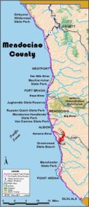
Legend: For details on the icons and trail colors, please click the legend icon on the map above.

Layers: Other layers are available. See the California Coastal Commission and Coastal Conservancy Completed Sections layer for the official completed trail segments. (About progress on the trail completion project.)
Mendocino Section 14
Navarro River to Elk
Towering cliffs plunge to a rocky, convoluted shoreline punctuated by tall sea stacks. Numerous steep canyons and pioneer cypress windbreaks dissect a high marine terrace with historic town sites. This may well be the most spectacular section of highway walking on the CCT, certainly one of the great photogenic legs of Highway 1. The bad news is that the sparsely settled headlands have ample space for a world class trail that does not yet exist. The good news is that the 1¼-mile span of trail at the section's beginning allows an undistracted look at some of this marvelous shore.
Follow the paved beach access road toward the river mouth. At ⅜ mile, just before an old house on the left, the pre-1960 roadbed of Highway 1 climbs behind the house. At the time of this writing the old road was signed, "CLOSED TO ALL VEHICLES AND PEDESTRIAN TRAFFIC . . but since that pavement now runs across county and state property and since the old access trail from the beach is no longer maintained, CCT veers left past the sign to follow the old pavement climbing south-southwest. (The beach road continues to Navarro Beach Campground, ¾ mile from Highway 1.) Ascend the old highway, overgrown in spots and wet in winter, but otherwise easy walking. After passing behind the old house, cross two seasonal creeks around ½ mile, then walk a stretch of road overgrown with alder and elderberry. You soon reach open pavement, then a grand view of the river mouth and the dramatic (especially from here) Arch of the Navarro.
At ⅝ mile you look down on the beach and campground, passing the old, now very overgrown access trail. Walk south on the crumbling pavement, ascending gradually along the face of a rocky cliff with grand views of river, mouth and spacious beach. Beyond ¾ mile a mudslide covers the pavement, but you can easily get around it. Climb past another mudslide, then a rockslide. Traverse skinny pavement along the base of the rock cliffs at one mile. Around 1⅛ miles the old highway has recently slipped out. Follow a volunteer path that veers left through a broken fence to cross grasslands briefly, then quickly cross the fallen fence to return to the roadbed beyond the slide.
Before 1¼ miles the road/trail reaches still maintained pavement. Continue past a cluster of homes up to a spur of pavement at 1⅜ miles that connects to Highway 1. The CCT follows the highway south to Elk. The only alternative is to go north ⅜ mile and follow Cameron Road as described in the Alternate Route.
The highway rises over Saddle Point, passes the Elk Guest House, then dips across a gulch before passing Devil's Basin on the right at 2⅜ miles. This amazing 200-foot-deep sinkhole has churning surf at its bottom, but you get only a glimpse from the road.
Overlook a dizzyingly rugged coast as the highway contours to 3¼ miles, then rises and dips three times, the last dip leading to the twisting descent of Cavanaugh Grade. Before the bottom of the grade at 4¼ miles, look south to the big field east of the highway. The town of Cuffey's Cove occupied the site in the late 1800s. The beautiful headlands of the Roth Ranch look inviting, but the area is patrolled lest you consider trespassing.
Highway 1 dips 1 across Sartori Gulch, then rises to the Cufley's Cove Cemetery at 4⅞ miles, a nice place to take a break. The highway descends fitfully with grand coastal vistas evolving with each step. After you enter the town of Elk at a big bend at 5⅝ miles, continue along the highway shoulder until you see the Greenwood State Beach Visitor Center on your right. For a break from the pavement, veer right and take the short trail south from the visitor center across the headlands to the Greenwood State Beach parking lot in the center of town around 6⅛ miles.
ALTERNATE ROUTE: To really stay off the highway for most of this section, you can follow a steeper, longer route up Cameron Road and down Greenwood Ridge Road to Elk. Only 3¼ miles longer than the highway route, its main disadvantages are the elevation change (an additional 800 leet+/920 feet-), limited coastal vistas, and the narrow, winding descent 2⅝ miles on moderately busy road at the end. Most of the route offers good views and very little traffic.
SUGGESTED ROUND TRIPS & LOOPS: Explore Navarro Beach and Bluffs at the start of this section. If you're adventuresome you might walk the first mile along the highway for some more grand views. Stay at the Elk Guest House and hike their headlands trails. Take the excellent, if demanding, bicycle loop up the Cameron Road Alternate Route, returning north on the highway.
Distance: 6⅛ miles (9.9 kilometers).
Open to: Hikers. Beach road and highway open to bicyclists.
Surface:
Access point: Navarro Beach Road at Highway 1.
How to get there: From Highway - just south of the Highway 128 junction and the Navarro River bridge, turn west at Milepost 40.15 and park. You can also drive .4 mile to trailhead parking.
Other access: Anywhere along highway segment.
Difficulty: Easy
Elevation gain/loss: 550 feet +/430 feet-.
Cautions: Watch for poison oak on the old highway.
Further information: Mendocino area State Parks (707)937-5804.
Facilities: Chemical toilets, picnic area.
Campgrounds: Primitive camping (no water) at Navarro Beach, .75 mile from access point. Also, Dimmick Campground 8 miles up Highway 128.
Lodging: Elk Guest House is on this section, plus several inns in Elk.

Interested in contributing to this project?
Register to add new photos and information, update existing results and share your trip reports.