
Usage Notes

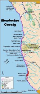
Legend: For details on the icons and trail colors, please click the legend icon on the map above.

Layers: Other layers are available. See the California Coastal Commission and Coastal Conservancy Completed Sections layer for the official completed trail segments. (About progress on the trail completion project.)
Mendocino Section 15
Elk to Alder Creek, Manchester State Park
Here's another section that follows Highway 1 for nearly its entire length. Fortunately traffic is usually light between the tiny towns of Elk and Manchester. Still, road walkers will find plenty of dangerous curves and blind spots as the highway dips through canyons and crosses high marine terraces with stunning coastal vistas. The frustrations of seeing vast open space as you walk the highway shoulder mount for through-hikers who, by section's end, have literally been "on the road" for all but two of the last twenty -four miles.
Happily through hikers can finish this section with a marvelous walk along attractive, secluded Irish Beach. Day hikers must note that they can only reach Irish Beach from its south end, namely the mouth of Alder Creek at the start of the next section, since there is no parking or public vehicle access to the north end of Irish Beach.
A pleasant side trail at the access point could potentially become a link in CCT. The ⅜-mile trail that descends to Greenwood Beach and Cove allows a closer look at this enthralling coast. Ten years ago a trail followed Greenwood Creek upstream to the highway bridge, but several years of harsh winters with high water and fallen trees obliterated the old path. Still, if you have time, we recommend visiting the beach.
Follow the shoulder of Highway l south out of town, descending across Greenwood Creek before ¼ mile, then climbing to a high grassy terrace at ⅝ mile. The highway contours across this terrace, staying close to the bluff's edge where cliffs plunge 200 feet to the breakers.
Around 2 miles you begin a winding descent into the deep, broad canyon of Elk Creek. After crossing the creek at 2½ miles, begin a corkscrew climb out of the canyon, ascending tight curves featured on local scenic postcards as "Dramamine Drive.”
Take a minute to catch your breath at the last sweeping turn around 3 miles where a spectacular view surveys canyon, cove and coast. The highway straightens out for a long, undulating crossing of a heavily farmed marine terrace, this one even higher than the last. Visibility is good here except at a set of curves bracketing the crossing of a seasonal creek around 5 miles. The long straightaway ascends one more hill then descends past Bridgeport Ranch at 6 miles, the center of a thriving agricultural community in the late 1800s. Then it's up and down to a winding crossing of Mills Creek around 6⅜ miles before the road straightens out again to contour south.
At 7½ miles you begin a descent that crosses Mallo Pass Creek at 7¾ miles. Today's landfill crossing of the creek's 200-foot deep canyon gives no indication what a barrier the canyon was to early travel along the coast. As you cross the deep canyon hidden in dense vegetation, look west to see the jagged rock pinnacles guarding the northern entrance of the cove to the west. As you ascend south you might take a break at the vista point around 8 miles that gives another view of this rugged hidden coast.
Continue along the highway shoulder as it tops a hill, then descends through the Irish Beach subdivision. Descend past the subdivision office (vacation rentals available, 707-882-2467) at 8⅝ miles, round a bend to the left and descend east to a one-way road on the right at 8¾ miles signed "DO NOT ENTER." The sign pertains to vehicle traffic. You want to turn right and descend the one-way narrow road yielding to vehicle traffic as you descend the canyon to the beach at 9⅛ miles.
To the north the beach ends at abrupt cliffs about ⅝ mile from Irish Gulch Creek, but to the south one long wave-swept beach stretches all the way to the mouth of the Garcia River 5 miles south just short of Point Arena. Walk to the tideline and follow it south to the mouth of Alder Creek at 10¼ miles. A roughly triangular lagoon marks the mouth of the creek. Its canyon is also the first big gap in the high cliffs and bluffs that back the beach north of Alder Creek.
Three notable facts mark Alder Creek. The San Andreas fault goes out to sea here. The 5272-acre Manchester State Park stretches south and southeast. The access road just south of the creek is this section's end and the start of Mendocino County Section 16.
ALTERNATE ROUTE: If you don't descend to Irish Beach, continue along Highway 1 to Alder Creek Road and the north end of Manchester State Park.
SUGGESTED ROUND TRIPS & LOOPS: Walk north along the tideline from the end of Alder Creek Road for about 1¾ miles. The walk south is covered in the next section.
Distance: 10¼ miles (16.5 kilometers).
Open to: Hikers. Bicyclists on road segment.
Surface: Highway shoulder, beach.
Access point: Greenwood State Beach parking lot, Elk.
How to get there: Turn west off Highway in the town of Elk, 16 miles south of Mendocino, at Milepost 34.05 into Greenwood State Beach parking lot.
Other access: Anywhere along the highway portion.
Difficulty: Easy
Elevation gain/loss: 850 feet+/990 feet-.
Cautions: Stay on shoulder, off roadway and watch for traffic. Use extreme caution when crossing highway. No parking or vehicle access at Irish Beach.
Further information: Mendocino area State Parks (707)937-5804.
Facilities: Chemical toilets, picnic area, phone.
Campgrounds: Nearest campgrounds are Navarro Beach (primitive) at start of previous section, Manchester State Beach and Manchester KOA on next section.
Lodging: Many in Elk.
Points of Interest

In the News
Interested in contributing to this project?
Register to add new photos and information, update existing results and share your trip reports.