
Usage Notes

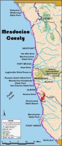
Legend: For details on the icons and trail colors, please click the legend icon on the map above.

Layers: Other layers are available. See the California Coastal Commission and Coastal Conservancy Completed Sections layer for the official completed trail segments. (About progress on the trail completion project.)
Mendocino Section 13
Little River to Navarro River
Such a beautiful stretch of coast deserves public access, but so far almost all of the next 8 miles of CCT are forced along the shoulder of busy Highway 1. As if that weren't bad enough, several of these miles follow narrow, twisting highway where drivers are either frightened or driving faster than safety allows or both. you walk this stretch, use extreme caution, hike in a group and wear bright clothing. Symbolically, the first sixteenth mile offers a safe trail off the highway, but most of the section offers hazardous walking on the highway shoulder.
From the beach parking lot walk east using extreme caution as you cross Highway 1. Continue to the Van Damme State Park entrance kiosk. A pleasant side trail that also serves as a CCT Alternate Route follows the park road ¾ mile to its end, then continues 2½ miles up Fern Canyon along Little River with a 3½mile loop at its end climbing to the Pygmy Forest. From the kiosk CCT takes the shady trail on the right that climbs south paralleling the highway. In about 300 feet it ends at the driveway for Little River Inn. Turn right and descend to the highway.
Head south along the highway shoulder, climbing a hill out of the "downtown" of the tiny town of Little River. Top a hill around ⅜ mile and descend past the cemetery, then climb over a second hill at ⅝ mile. The highway descends until one mile where it crosses Buckhorn Creek as the road narrows. Ascend moderately to crest Stilwell Point at 1⅝ miles, then contour through tight winding turns with lousy visibility. Descend past Heritage House Inn and across tiny Smith Creek.
Around 2⅝ miles an unmarked side trail on the right descends to a deep cove at the mouth of Dark Gulch. Descend the highway east across Dark Gulch at 2⅞ miles, then ascend it west, rounding a big bend to return to the coastal terrace around 3⅛ miles. Ascend gently south, then descend toward the town of Albion. A short dip and climb leads to the north end of the Albion River bridge around 4 miles. Just before the bridge, on the left Albion River North Side Road descends to a private campground along the lower river. If you camp there, you might find someone with a boat to shuttle you across the river, then ascend Albion South Side Road through the heart of the little town to rejoin the highway.
CCT crosses the high Albion River bridge and follows Highway 1 past the heart of town (just up Albion Ridge Road) at 4½ miles. Residents, the Coastal Conservancy and some state legislators are working to acquire 502 acres in coastal Albion for a state park that would provide several miles of a fine CCT route. Around 4¾ miles follow the highway as it dips across Salmon Creek's canyon with Whitesboro Cove to the west, then climb a long straight hill to its top at 5⅜ miles. Enjoy the wide highway right-of-way as you contour to Navarro Ridge Road at 5¾ miles.
The highway narrows, then climbs as it winds over Navarro Head, where Mendocino Land Trust acquired 55 acres west of the highway including rugged Navarro Point in late 1999. It will eventually provide a short off-Highway 1ink for the CCT. Begin a gradual descent, but be prepared for narrow blind curves ahead.
At 6⅜ miles the highway bends sharply left to make a wiggling descent northeast. If you can find a safe place to stand off the road, enjoy the stunning views south along the coast all the way to Point Arena, then down over the estuary of the Navarro River.
By 7⅜ miles the worst of the curves are over and you have descended nearly to sea level, overlooking an island in the nearby broad Navarro River. Walk the shoulder to the Highway 1 bridge across the Navarro at 7¾ miles. Turn right and cross the bridge, coming to Navarro Beach Road at 7⅞ miles, start of Mendocino County Section 14.
ALTERNATE ROUTE: Through-hikers can hike to the Pygmy Forest, then follow Albion Little River Road south to Albion. It's steeper and twice the length of highway route to Albion, but more enjoyable with little traffic.
SUGGESTED ROUND TRIPS & LOOPS: The best choice is the trail up Fern Canyon and the Pygmy Forest loop, 8½ miles round trip from the Van Damme kiosk.
Distance: 7⅞ miles (12.7 kilometers).
Open to: Hikers, bicyclists.
Surface: Trail, highway shoulder.
Access point: Van Damme Beach parking lot, Little River.
How to get there: Turn west off Highway 1 south of Mendocino at Van Damme State Park, Milepost 48.05, into paved parking lot.
Other access: Anywhere along section.
Difficulty: Easy
Elevation gain/loss: 710 feet+/690 feet-.
Cautions: Stay on shoulder, out of road, and watch for traffic. Use extreme caution crossing highway.
Further information: Mendocino area State Parks (707)937-5804.
Facilities: Chemical toilets, picnic area, phone, water at access point.
Campgrounds: Van Damme State Park at the north end has 85 units. Navarro Beach unit of Navarro River Redwoods State Park at the south end has primitive sites, no water. In Albion private Albion River Campground has sites on the river.
Lodging: Several in Little River and Albion.
Points of Interest

In the News
Interested in contributing to this project?
Register to add new photos and information, update existing results and share your trip reports.