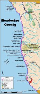
Mendocino Section 17
Stoneboro Road at Highway 1 to Moat Creek
Most of the first two-thirds of this section offers a pleasant road walk, assuming the Garcia River is shallow enough to ford when you get to it. However, the final leg south from the town of Point Arena along Highway 1 until you reach Moat Creek leaves much to be desired. Worst of all, you overlook lightly populated, mostly pastoral coastal bluffs that would be an ideal place for the Coastal Trail. You might plan time to enjoy a meal out in Point Arena, the largest coastal town between Mendocino and Gualala at the Sonoma County line. After Gualala you won't see another town of notable size until Bodega Bay 40 miles south.
For lack of continuous public access along the coast, the current route of CCT turns inland. From Stoneboro Road walk the highway shoulder south for ¼ mile to Mountain View Road where you must make a decision. At times of high water, generally October to May, you may not be able to ford the Garcia River on the main CCT route along Windy Hollow Road. In that case, follow the Alternate Route. When the ford is safe, go left on Mountain View Road, then immediately right, following a dirt road through the pioneer Manchester Cemetery to its southwest corner. There you pick up Windy Hollow Road, a sleepy lane that descends a cypress-lined ridge to the Garcia River at one mile.
At the time of this writing, there was no bridge across the river, requiring a ford that is usually easy from about June through September, but should never be attempted at high water. Beyond the gravel riverbed surrounding the ford, you again pick up Windy Hollow Road to climb over a ridge with views west to the Point Arena Lighthouse around 1⅜ miles. Your road descends to Hathaway Creek at 2 miles, then rises gently along its south fork to 3 miles. Ascend moderately to Windy Hollow Road's end at Riverside Drive. Turn right for a brief block and come to Main Street/Highway 1 in Point Arena at 3½ miles.
The CCT turns left and descends on the sidewalk through the compact town's commercial district. Just before the bottom of the hill, Port Street on the right heads west to Arena Cove, coastal access, and the rightful route of CCT.
However, due to private property south of the cove for now the CCT continues south on Highway 1, climbing a canyon out of town and quickly gaining a ridge with expansive views around 4¼ miles. The rolling headlands to the west are where the CCT should be. For now be grateful the stint on the highway is short. At 5 miles the highway descends, coming to Moat Creek at 5¾ miles where the next section of CCT begins at the parking lot west of the highway.
ALTERNATE ROUTE: When the Garcia River is too high to ford, you must walk Highway 1 all the way from Stoneboro Road to Point Arena. When you get to town, follow Lake Street to town center.
SUGGESTED ROUND TRIPS & LOOPS: Windy Hollow Road offers a pleasant walk or bike ride as does the side trip to Arena Cove. A seafood cafe and pizza parlor are near the pier there.
Distance: 5¾ miles (9.3 kilometers).
Open to: Hikers, bicyclists.
Surface: Road shoulder, highway shoulder.
Access point: Highway at Stoneboro Road.
How to get there: Turn west off Highway at Milepost 19.65 south end of Manchester onto Stoneboro Road and park.*
Other access: Downtown Point Arena or anywhere along this road section.
Difficulty: Easy
Elevation gain/loss: 570 feet+/600 feet-. To Point Arena: 450 feet+/320 feet-.
Cautions: Garcia River ford is not safe at high water in winter and spring. See Alternate Route. Bicyclists may not be able to ford river even in summer.
Further information: Mendocino County Road Department (707)463-4363.
Facilities: None at start. Restrooms, water, phone in Point Arena.
Campgrounds: None on route but Rollerville Junction is on Highway 2.6 miles south of Stoneboro Road. Also see previous section.
Lodging: Several in Point Arena.
Points of Interest
In the News
Interested in contributing to this project?
Register to add new photos and information, update existing results and share your trip reports.


