
Usage Notes

Legend: For details on the icons and trail colors, please click the legend icon on the map above.

Layers: Other layers are available. See the California Coastal Commission and Coastal Conservancy Completed Sections layer for the official completed trail segments. (About progress on the trail completion project.)
Mendocino Section 7
Ten Mile River to Fort Bragg, MacKerricher State Park
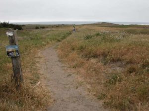
The Old Haul Road, the seaside portion of a former private logging road between the lumber mill at Fort Bragg and the forests of Ten Mile River, has become a community institution. People of all ages come here from morning until night to walk, bike or jog. Generally the crowds stay along the southern half. The northern end sees scant traffic once it leaves the beautiful Ten Mile River estuary. If you prefer to stay off the pavement, you can walk the beach south from Ten Mile River for about 4 miles (Alternate Route A), jog east to follow the Haul Road about a mile, then follow longer, meandering Alternate Route C along the blufftop to Pudding Creek.
Before the road was laid in 1949, a logging railway built in 1916 followed the same route. When storm surf destroyed a mile of the road in 1982, log trucks switched to the nearby highway. State Parks bought the road in 1994, saving it from development after the timber corporation that owned it threatened to sell to the highest bidder. Coastwalk and many individuals who use the Haul Road protested the attempt to sell the road to anyone other than state parks. Recently, the MacKerricher Park General Plan abandoned the plan to build a boardwalk or paved path to bridge the gap in the Haul Road around 3 miles. It would've had a big impact on the sensitive environment of Ten Mile Dunes. Plans still include restoring the old railroad trestle at section's end and opening it to pedestrian traffic.
From the parking area, take the path that descends north toward the river, dropping over sand dunes to the paved Old Haul Road. Follow the pavement toward the river mouth, guarded on the north by the sea stacks of Seaside Beach. By ½ mile the Haul Road starts a big bend left to head south paralleling the shore. You meet the Alternate Route from Seaside Beach here, coming south from the seasonal ford at the river mouth. See Section 6 Alternate Route. You can take a side trip north about ¼ mile to the river's mouth, and/or you can veer west here and walk the beach south. See Alternate Route A.
The Haul Road angles south-southwest through the extensive Ten Mile Dunes. This was the site of the Mendocino Indian Reservation from 1856 to 1866, the fourth reservation in the nation. Traverse the broadest section of the dunes at 1½ miles, then cross Inglenook Creek around 1⅞ miles. The level, nearly straight road continues along the shore. Cross the small creek that flows from nearby Sandhill Lake and its adjacent Inglenook Fen at 2⅜ miles, then pass an old farm gate on the left. The next ¼ mile of pavement is often covered with sand and some of it has been damaged by the surf.
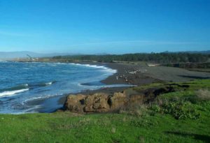
Around 2⅝ miles the Haul Road ends abruptly where powerful winter storm surf destroyed a mile of road. While you can continue straight across the soft dunes, the best walking follows the tideline 200 feet west. Watch for sneaker waves as you follow the wet sand south for about a mile.
By 3⅜ miles you'll again see the Haul Road on your left at the top of a 30-foot bluff. You can return to the pavement via a horse trail here or walk the beach up to another ½ mile if the tide isn't too high. Back on the pavement, you quickly see signs of civilization. Before 3⅞ miles you pass the Ward Avenue access and continue along the pavement above tiny pocket beaches sandwiched between rocky headlands.
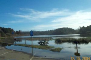
By 4⅜ miles the state park campground lies to the east. After a side trail west to the beach, a second spur forks east to the wooded campground. After a horse trail forks east at 4¾ miles, dark-sand Cleone Beach (Alternate Route B) is on your right. You quickly reach a spot where storm surf reduced the elevated Haul Road to a narrow dirt track for 500 feet. Freshwater Lake Cleone lies to the east.
After the pavement resumes, it soon crosses a wooden overpass then at 5⅛ miles passes a gravel track on the right that leads to the Laguna Point parking lot and Alternate Route C.
The Haul Road route immediately comes to a silver gate where a side trail heads east to the nearby campground which includes pleasant walk-in sites very close to the CCT. Haul Road and CCT continue south through a corridor lined with shore pines and wax myrtles. From 5½ miles, the Haul Road mostly has state park lands only to its west with the rocky shore nearby. At 6⅜ miles your route dips across Virgin Creek on a wooden bridge. Soon an industrial zone lines the east side of the road, followed by several motels. It must be time to welcome through-hikers back to civilization for what it's worth!
A second silver gate marks another access point to the Haul Road at 7⅛ miles. If you are walking into Fort Bragg, the Haul Road continues to the north end of the old Pudding Creek Trestle, the original railroad bridge dating from 1916, at 7⅜ miles. Until the trestle is restored for foot traffic, you must take the narrow dirt path on the left that descends to the parking area for Pudding Creek Beach. Then walk south along the parking area to the Pudding Creek highway bridge and cautiously walk the shoulder up the hill. At the stoplight, turn right on Elm Street and go two blocks west, then north to the end of the street and the south end of the trestle and section's end.
Once the trestle opens to pedestrian traffic, CCT will simply follow the Haul Road over the trestle to its south end at 7½ miles.
SUGGESTED ROUND TRIPS & LOOPS: In late summer and autumn when Ten Mile River is low enough to ford, cross it and walk north to Seaside, about 2 miles round trip from access point. Walk the Old Haul Road to the break and return on the beach, 5¼ miles round trip. From Laguna Point lot, walk west to the point and follow the bluff trail south to Virgin Creek Beach, returning by the Haul Road if you'd like, about 3 miles total. At Lake Cleone, a pleasant 1⅜-loop circles the lake. The first portions of the latter two choices follow raised boardwalks passable to wheelchairs.
ALTERNATE ROUTES:
A) From the mouth of Ten Mile River or the side trail to it, you can walk the beach rather than the pavement for about 3 miles, requiring two creek fords in winter and spring. Then rocky headlands make the Haul Road the best choice.
B) At Cleone Beach the tideline is again easy to follow to the Laguna Point parking lot.
C) At Laguna Point you can follow a boardwalk west, then a bluff edge trail south along the shore to Virgin Creek Beach, then a dirt path again to Pudding Creek, adding ½ mile to one mile to total.
Distance: 8⅜ miles until trestle opens, 7½ miles with trestle open (13.4 or 12.1 km).
Open to: Hikers. Bicyclists on part, equestrians on alternate routes, wheelchairs on part.
Surface: Paved road closed to motor vehicles, beach, trail, highway shoulder.
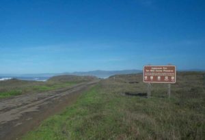
Access point: South end of Ten Mile River bridge.
How to get there: Turn west off Highway I north of Cleone and Fort Bragg, south of Westport at Milepost 69.67 into small dirt parking lot.
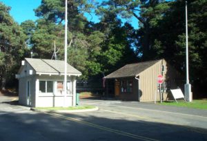
Other access: Main park entrance at south end of Cleone at Milepost 64.87, parking lot west of Highway I at Milepost 62.7, north end of Fort Bragg.
Difficulty: Easy
Elevation gain/loss: 160 feet+/150 feet-; once trestle opens: 110 feet+/110 feet-.
Cautions: Blowing sand can make this walk miserable in high winds, especially north half.
Further information: Mendocino area State Parks (707)937-5804.
Facilities: None at access point, but MacKerricher State Park has restrooms, water, phones, picnic areas, campgrounds.
Campgrounds: MacKerricher State Park has 143 sites and walk-in sites adjacent to trail.
Lodging: Cleone Lodge nearby, many choices in Fort Bragg.

Interested in contributing to this project?
Register to add new photos and information, update existing results and share your trip reports.