
Usage Notes

Legend: For details on the icons and trail colors, please click the legend icon on the map above.

Layers: Other layers are available. See the California Coastal Commission and Coastal Conservancy Completed Sections layer for the official completed trail segments. (About progress on the trail completion project.)
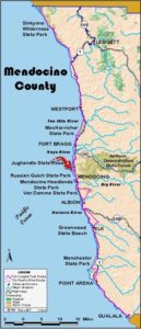
Mendocino Section 9
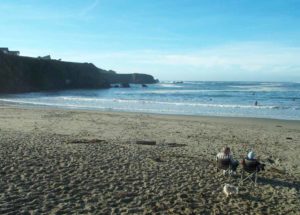
Pine Beach Inn to Point Cabrillo Preserve
The big news in Mendocino Section 9 is that the Caspar headlands have been preserved and that the CCT follows a fine and historic new route there. See below for details. This section starts on an old portion of Highway 1 that the state abandoned around 1960. After CalTrans opened the new highway to the east, they sold the old right-of-way where it crossed Mitchell Creek just north of this access point. You can still walk north on Ocean Drive past the Pine Beach Inn to find the roads current terminus at Pine Beach at the mouth of Mitchell Creek. The private property sold off by the state precludes continuing north to the rest of the old highway, called Ocean Drive, only 300 feet north.
State Parks acquired the headlands north of Jughandle Creek just in time to keep the right-of-way for the CCT. The surrounding subdivisions attest that the park acquisition was none too soon. If you stay nearby or have extra time, you'll want to explore sheltered Jughandle Cove, a short walk from the Jughandle parking lot, or take the famous Jughandle Ecological Staircase Trail. This 4½- or 5-mile round trip, depending on whether you take the ½-mile headlands loop, explores the uplifted marine terraces that have formed the gentle landscape along this part of the Mendocino coast. The Staircase Trail ends in the amazing Pygmy Forest Reserve where century old trees stand only waist high. If you go, the brochure available at the Jughandle parking lot is recommended.
South of Jughandle State Reserve, CCT passes through the former lumber town of Caspar, where residents have been organizing since 1998 to acquire large portions of the quiet town and its surroundings that were for sale. Happily they succeeded in acquiring 142 acres for public access, including the dramatic south headlands. You can now walk those headlands, recently deeded to state parks, on a scenic hike that follows an historic route and adds a fine ⅜ mile to this section. After fording Caspar Creek and crossing Caspar Beach, the section follows the old highway again to Point Cabrillo Preserve.
The CCT heads west through grasslands and shore pine forest with private property immediately to the north. Beyond ¼ mile, two side trails fork right to cross a seasonal creek and head northwest to Mitchell Point. Continue west as the trees soon part to reveal a convoluted, rocky shore.
By ⅜ mile you reach a narrow promontory with pocket beaches on both sides. CCT turns southeast along the bluff's edge and soon comes to a fork above tiny Bromley Creek. Turn right and descend beside the creek to secluded Bromley Beach. Cross the creek and walk south across the beach to its southern end at ½ mile. A steep, sometimes slippery footpath there requires scrambling up the bluff face to the level headland on top. Walk east briefly, then turn south and descend across another seasonal creek and climb up the other side. Veer right at a fork and follow the bluff's edge out to another point, then southeast to another junction.
Since private property lies to the south, you want the trail on the left that heads east, coming almost back to Highway 1 at 1¼ miles, directly opposite Gibney Lane and Annie's Jughandle Beach Inn. When you come to a gravel road, turn right and follow it south, paralleling the highway.
Shortly after the driveway turns right, you come to a private property sign. This is your cue to leave the road and head south, again paralleling Highway 1, this time a through a grassy field which often has no obvious path. Watch for uneven footing on this lightly traveled leg. Pick your way south until you find a broad track around 1⅝ miles, the Jughandle North Headlands Trail. You can use it as a side trail to head west to the bluffs north of Jughandle Cove, but CCT only veers west briefly, about 50 feet on the North Headlands Trail. Then pick your way south on one of the vague tracks parallel the highway for 500 feet before turning east on a path that quickly dips under the north end ot the Jughandle Creek highway bridge.
On the east side of the highway you meet the Jughandle Ecological Staircase Trail. A left turn leads to a great 1⅝-mile side trip to the otherworldly Pygmy Forest Reserve. The CCT turns right and descends into Jughandle Creek canyon, a crossing a bridge over the creek around 1⅞ miles. Turn right and climb the stairway past some of the southernmost specimens of Sitka spruce in North America. At the top, turn right and follow the path under the highway at the south end of the bridge, then turn south through lush vegetation above Jughandle Cove. Stay to the left at the next junction and you'll come to the Jughandle State Reserve parking lot at 2⅛ miles where you'll find privies, a water faucet and a picnic area.
CCT follows the Ecological Staircase Trail west onto the Jughandle Headlands south of the cove. In less than ⅛ mile, take the trail that forks left to head south. It angles toward the southeastern corner of state park land, where it meets Caspar Road at 2½ miles.
Follow the new gravel path south along the west shoulder of this old Highway 1 leg l through sleepy Caspar, once a booming lumber town. By 3 miles you pass the new Caspar Community Center behind the Mendocino Coast Jewish Center on your left. Continue on the gravel shoulder path. Once you pass Caspar Street on the left, state park's new Caspar Headlands parcel is to the west. Eventually a gate here will allow CCT to head west to explore more of Caspar Headlands. (If the gate is there, by all means go that way.) For now CCT continues on the gravel path to the end of Caspar Road at 3⅛ miles.
From road's end, the new CCT link heads west from the southernmost of the two gates onto the Caspar Headlands. By 300 feet you encounter remnant pavement from Caspar's old railroad and lumber drying yards, which once occupied these bluffs. Follow the two-wheel track winding west. Before 3¼ miles the track splits in two. While you can take the right fork to explore more of Caspars headlands, CCT takes the left fork, winding west to near the bluff's edge at 3⅜ miles, where a loading chute once supplied lumber ships anchored in Caspar Cove below.
CCT turns left, following a path south that soon veers left toward Caspar Beach. At 3½ miles CCT veers to the right on a path that descends gradually east-southeast to the right of a cypress windrow, following the old tramway incline down toward the mill site. Pass through a gate and descend the path, passing through a brushy area around 3⅝ miles. As you approach a grove of eucalyptus, take the second of two rough paths on your right and descend to Caspar Creek. A pedestrian bridge may eventually be built here. For now, if the creek is low, turn right and walk to its mouth and ford (you can usually rock hop across) to reach Caspar Beach. When the water is higher, you'll likely need to wade.
Either way you come to little Caspar Beach south of the creek at 3¾ miles. Walk the tideline south to ford even smaller Doyle Creek, then angle southeast to Point Cabrillo Drive, another former stretch of Highway 1, at 4⅛ miles. Walk the road shoulder south, climbing by two tight hairpin turns.
At the top of the hairpins, follow Point Cabrillo Drive as it climbs south. The road contours from 4¾ miles with ocean views over the pristine Point Cabrillo Light Station and Preserve. This section ends at 5 miles at the Preserve's main entrance. CCT heads west on a semi-paved road north of the new parking area. (The gate marked "13800" has been removed.)
SUGGESTED ROUND TRIPS & LOOPS: Walk the first 1⅝ miles of this section and return, 3¼ miles round trip, or you can add side trips to Mitchell Point or Jughandle North headlands. Take the great Jughandle Ecological Staircase Trail to the Pygmy Forest, 4½ miles round trip with a short loop at the end.
Distance: 5⅜ miles (8.6 kilometers).
Open to: Hikers. Bicyclists on road portion.
Surface: Trail, beach, gravel road, paved road.
Access point: Trailhead near Pine Beach Inn.
How to get there: Turn west off Highway at Milepost 57.6 south of Fort Bragg, north of Caspar onto Ocean Drive at Pine Beach Inn. Turn left into dirt trailhead parking just after Pine Beach Inn sign.
Other access:
Difficulty: Easy
Elevation gain/loss: 360 feet+/290 feet-. To Jughandle parking lot: 110 feet+/150 feet-.
Cautions: Don't trespass on adjacent private property. Use caution at Caspar Creek ford and don't interfere with fish migrating upstream in wet season or migrating birds in spring and fall. Dogs must be leashed on Caspar Beach.
Further information: Mendocino area State Parks (707)937-5804.
Facilities: None at access point. Chemical toilet, water, phone, picnic area at Jughandle parking lot. Chemical toilet at Caspar State Beach.
Campgrounds: Pomo Campground and Woodside Trailer Park are one mile north. Caspar Beach RV Park and Campground is on route near section's south end. Jughandle Creek Farm & Nature Center, (707)964-4630, has hostel-style lodging in seven rooms of their 100-year-old farmhouse near Jughandle Creek.
Lodging: Pine Beach Inn is at trailhead, Annie's Jughandle Beach Inn is on highway .25 mile south of access point. Other lodging in Fort Bragg.
Points of Interest

In the News
Interested in contributing to this project?
Register to add new photos and information, update existing results and share your trip reports.