
Usage Notes

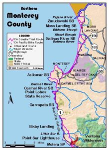
Legend: For details on the icons and trail colors, please click the legend icon on the map above.

Layers: Other layers are available. See the California Coastal Commission and Coastal Conservancy Completed Sections layer for the official completed trail segments. (About progress on the trail completion project.)
Monterey Section 9
Old Coast Road, Bixby Bridge to Andrew Molera State Park
Big Sur remained a coastal wilderness after most of the California coast had been settled, its steep and rugged terrain throwing up barriers to all kinds of travel. The native Esselen people left their harsh native lands to settle near the Catholic missions in the 18th century. While a few solitude loving settlers arrived before 1870, a small community only finally developed in the Big Sur River Valley in the 1870s. By 1900 landings for ships had been built at Palo Colorado Canyon and Bixby Creek in the north and at Partington Cove and the mouth of Big Sur River in central Big Sur. In that year Big Sur residents built a road south from Malpaso Creek to Bixby's, but only a rugged pack trail continued south. By 1910 one could take a ten-hour stage ride from Monterey to the new Pfeiffer's Resort, which operated on the site now occupied by Big Sur Lodge. That stage followed what's now called Old Coast Road, the CCT route today.
Only in 1919 did work begin on surveying a highway along the Big Sur coast between Carmel and San Simeon. Local residents, hardened by their wilderness lifestyle, scoffed, claiming the road would only be built as Hearst's personal driveway. Construction began in 1921 only to be put on hold by a skeptical governor from 1923 to 1927. When building resumed, convict crews provided the labor. In 1934 a rough road finally opened, but creek crossings were steep and chancy in the several spots where bridges hadn't yet been built. Finally in 1937 this dramatic leg of Highway 1 officially opened.
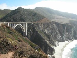
In the meantime the bridge over Bixby Creek had opened in 1932. Called Rainbow Bridge at the time, it was then the longest concrete arch bridge in the west. We call it Bixby Bridge today. It's still the longest bridge in Big Sur and one of the most dramatic spans in the world with its setting at the precipitous meeting of land and sea. Completion of the bridge made the inland route up Bixby and Sierra Creeks a side road except when the new coast route was closed by slides or washouts. The bridge gained further fame in the 1950s when Beat writer Jack Kerouac wrote about his stay in Lawrence Ferlinghetti's cabin beneath the bridge.
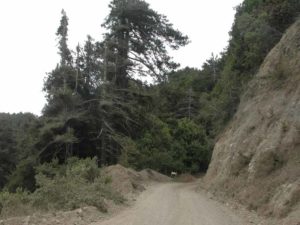
Today Old Coast Road offers a steep route almost entirely through private property, but one that provides a pleasant and remote track, a preferable alternative to walking the narrow shoulders of the busy highway. Old Coast Road presents steep hills, rewarding vistas and intimate contact with lush stream corridors, most notably the beautiful crossing at the Little Sur River. South of the river, the road offers access to the Little Sur Trail, a route into the Ventana Wilderness. The last time we took Old Coast Road, we saw the local sheriff taking a nap at the grandest vista point and only four cars in the 10½ miles.
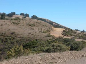
The California Coastal Trail follows the dirt track of Old Coast Road, ascending a hill with great views on the right into rugged Bixby Creek Canyon where the road soon leads. Be sure to look behind you for awesome vistas of the gracefully arched Bixby Bridge. Pause when you reach the summit at ⅜ mile to absorb the route's only views north along the coast.
Follow Coast Road on a winding steep descent, crossing Bixby Creek before one mile. Ascend along the west wall of the canyon where redwoods grow from the steep rocky slope. After a brief descent around 1⅝ miles, your gradual climb resumes. By 2⅛ miles you're ascending along Sierra Creek, an alder-lined fork of Bixby Creek that lies 50 feet below the road on your left. Beyond 2½ miles your ascending road quickly crosses the creek five times. From 3 miles redwood groves offer some shade. After passing a lovely grove across the creek on the right at 3⅜ miles, the ascent turns moderate. Leave the canyon by a hairpin turn to the right at a 3¾ miles, beginning a steep climb with expanding coastal views.
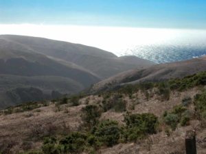
Reach Sierra Summit by 4 miles after gaining 1100 feet in a 3-mile ascent. Ocean vistas there range from northwest to south. Pass a sign informing you that the private lands of El Sur Ranch line the road for the next 6 miles. Make a winding descent across steep chaparral slopes with scattered cypress and yuccas and views of 3710-foot Pico Blanco southeast. According to Ohlone legend, this dramatic peak was where Coyote brought civilization to people.
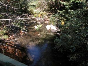
Descend past a spring on the left around 5¼ miles, then through a stand of Bishop pines followed by redwoods. Reach the Little Sur River at the confluence of its main and south forks at 5¾ miles, crossing it on a Bailey Bridge in a gorgeous spot beneath large pines, redwoods, alders and maples. You quickly cross the South Fork on another Bailey Bridge, then begin a steep ascent.
After a tight hairpin turn around 6¼ miles, watch for a wide spot in the road, one of the few places several cars might park on Old Coast Road. East of the road here is the unmarked start of the Little Sur Trail which descends to ford the South Fork Little Sur River, entering Ventana Wilderness and Los Padres National Forest in about one mile. That trail then climbs over the flank of Pico Blanco and ends in 6⅛ miles at the Mt. Manuel Trail, which leads north to Bottchers Gap and south to Pfeiffer-Big Sur State Park.
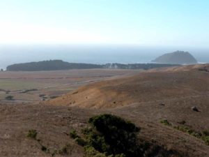
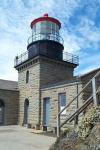
CCT continues along Old Coast Road, climbing through oak woodlands. By 7¼ miles you gain views of Pico Blanco to the east and the canyons of the Little Sur River. As you approach the road's third summit (942 feet) before 8 miles, magnificent views open to the southwest of the coastal marine terrace and ocean. A winding descent drops through oak woodlands with periodic coastal vistas. By 8½ miles you're back among redwoods. The road contours from 8¾ to 9¼ miles with vistas of Molera Point and the mouth of the Big Sur River. As you resume a steady descent, the magnificent view expands to include Point Sur and its historic lighthouse, then more of the Big Sur River Canyon.
The road drops into Molera State Park around 10¼ miles, passing a trail on the right that leads nowhere. Continue down the road to its end al Highway 1 at 10½ miles. Be very careful and watchful of speeding cars as you cross the highway and descend the signed paved road into the heart of Molera State Park. Turn right at 10¾ miles and walk past the entrance kiosk, coming to section's end in the main Molera parking lot.
ALTERNATE ROUTE: A CCT Big Sur High Route could ascend Palo Colorado Road from Garrapata State Park to Bottchers Gap, then follow the Mt. Manuel Trail past Pico Blanco Boy Scout Camp. In summer or early autumn, when you're certain you can safely ford the Little Sur River, you could turn right and descend the Little Sur Trail to Old Coast Road. Otherwise, one could continue on the Mt. Manuel Trail to Pfeiffer-Big Sur State Park, finding the way from there to Ventana Inn and the start of Section 11.
SUGGESTED ROUND TRIPS & LOOPS: The highlights of this steep and winding dirt-road route are the views from the three summits, with the first one only ⅜ mile from the highway, a brisk but short climb from Bixby Bridge. Whether or not you walk the entire road, consider a side trip on the Little Sur Trail down to the ford or up from there to the Geer Homestead site at 2¾ miles.
Distance: 10¾ miles (17.3 kilometers).
Open to: Hikers, bicyclists.
Surface: Dirt road.
Access point: North end of Bixby Bridge on Highway 1.
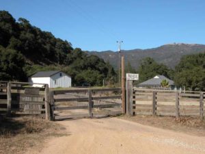
How to get there: Drive south on Highway from the Monterey Peninsula. In 13.1 miles from Carmel River bridge, turn left at Milepost 59.15 onto unpaved Old Coast Road and park.
Other access: Anywhere along route.
Difficulty: Hard
Elevation gain/loss: 2110 feet+/2340 feet-.
Cautions: Watch and listen for traffic. Stay off adjacent private property. Road may be impassable to vehicles after wet weather. No camping allowed along Old Coast Road.
Further information: Monterey County Road Department (831)755-4925.
Facilities: None except at Molera State Park at south end, which has chemical toilets, water, phone.
Campgrounds: Molera Walk-In Camp is at south end. Car camping available along Highway I south of Molera at three private campgrounds and Pfeiffer-Big Sur State Park.
Lodging: None on route. See Lodging for Sections 6, 8 and 10.
Points of Interest

In the News
Interested in contributing to this project?
Register to add new photos and information, update existing results and share your trip reports.