
Usage Notes

Legend: For details on the icons and trail colors, please click the legend icon on the map above.

Layers: Other layers are available. See the California Coastal Commission and Coastal Conservancy Completed Sections layer for the official completed trail segments. (About progress on the trail completion project.)
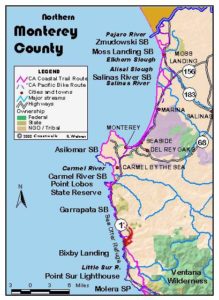
Monterey Section 8
Point Lobos State Reserve Entrance to Bixby Bridge
This section marks the passage from the urbane and affluent Monterey Bay area to wild and remote Big Sur. Photographer Ansel Adams lived much of his life in a house above Malpaso Creek, looking south over the dramatic coastal landscape, preserved since 1980 in 3000-acre Garrapata State Park. Adams' black-and-white images of this shoreline have attained near archetypal status as photography's representation of oceanside beauty.
The Coastal Trail is forced to follow the shoulder of busy Highway P for most of the section, but progress is being made. The only exceptions to the highway hike are the pleasant walk through Adams' adopted town-the upscale oceanside community of Carmel Highlands and the invigorating blufftop trails of Garrapata State Park. At press time only two short blufftop paths provide a through route for the CCT at Garrapata, but there will soon be more. The southernmost CCT blufftop link here was constructed in summer 1999, and one or two more blufftop paths are due to be built in spring 2000. We mention the locations of these new CCT links although they were not done when we go to press.
From Point Lobos State
Reserve entrance, CCT follows the shoulder of Highway 1 south. After ⅜ mile it crosses Gibson Creek and leaves the reserve, quickly entering the small town of Carmel Highlands. At ¾ mile, CCT and the highway pass the last general store/gas station until Big Sur on Section 10. Continue along the shoulder of the winding highway with occasional coastal views, crossing the historic 1933 Wildcat Canyon bridge at 1⅜ miles.
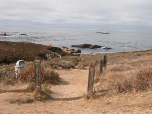
Watch on your right for Spindrift Road at 1½ miles. CCT turns right to descend along Spindrift. After a short ascent around 1¾ miles, the descent continues with spectacular coastal vistas including a look north to the rugged Point Lobos shore. Ascend Spindrift Road to Highway 1 at 2⅜ miles, then turn right and follow the highway shoulder south ⅛ mile.
Around 2½ miles CCT turns right on Yankee Point Drive. Descend along the quiet residential street with glimpses of the coast until 3¼ miles. Then follow Yankee Point Drive as it climbs toward the highway. Be sure you turn right at the intersection of Yankee Point and Carmel Riviera Drive, following Yankee Point Drive to Highway 1 at 3⅜ miles.
CCT turns right and follows Highway 1's shoulder south, quickly crossing the 1935-vintage Malpaso Creek bridge. Rugged Malpaso Creek marks the start of Big Sur, which extends south 70 miles to San Luis Obispo County. Follow the highway as it contours down coast, crossing another canyon around 3¾ miles, then entering Garrapata State Park at 4⅛ miles, with the park on both sides of the highway.
Cross another canyon at 4¼ miles and pass the first shoreline access for the park, a path through the fence west of the highway, marked "1." Typical of access paths in this mostly narrow coastal state park, that path descends to tideline but has no access up and down the coast. This point is more notable for your first clear view south to the high promontory of Point Sur.
Continue down the coast on narrowing highway shoulders. CCT and Highway 1 cross a landfill over another canyon at 4⅝ miles. By 4⅞ miles the road widens, providing adequate shoulders once again. Climb over a rise, then descend to cross two more canyons around 5⅛ miles.
After following the highway shoulder over another rise, dip down past coastal access gate 7 at Milepost 65.9. The spur trail descends west to overlook Soberanes Creek Beach, created when recent El Niño storm waves piled tons of sand on a previously submerged rocky tideline. Eventually the CCT will likely leave the highway at gate 7, but to do so now requires a difficult ford of Soberanes Creek. Follow the shoulder south over a landfill crossing of Soberanes Creek at 5½ miles. Immediately beyond the creek you have a choice. The shortest route follows the highway another ⅛ mile to gate 8. For a longer blufftop route, CCT turns right just south of the creek and descends a narrow path west following the bank of the creek to the point southwest of the creek's mouth at 5⅝ miles, where spurs descend to fishing access. CCT turns south to contour along the bluff edge. In about 250 feet it meets a spur that drops south to the rocky shore of Moby Ling Cove, a.k.a. North Soberanes Cove. CCT heads east briefly, then angles southeast toward a cypress grove. Before the grove it meets the well beaten path from nearby gate 8 on your left.
Veer right and follow the trail south into the cypress grove at 5⅞ miles where you'll find an outhouse. CCT leads out of the grove to a junction with an overgrown trail on the left at 6 miles. That spur leads to the top of nearby Whale Peak, but CCT continues straight, passing another spur on the right in about 200 feet. The through trail soon climbs steps to overlook a keyhole cove a on your right. Continue along the path heading toward the point on the ocean side of Whale Peak.
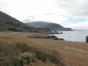
Around 6⅛ miles the trail forks again, this time with both choices being through trails. You can take the right fork for a closer look at the shore around the northern point that faces Lobos Rocks offshore, but the CCT contours straight across the headlands covered with coastal scrub vegetation. In 450 feet the lower path rejoins the CCT. By 6¼ miles the ocean churns directly below. Descend toward Soberanes Point, the southernmost of the two nearby points. As you descend, the high rise of Point Sur appears to the south.
Reach Soberanes Point beyond 6⅜ miles where you pass a metal bench mark placed in 1875 and side trails to the tideline. CCT turns east to follow the winding bluff edge toward the highway. It soon turns north heading for Whale Peak. By 6⅝ miles you reach a fork where the spur on the right heads to a nearby outhouse. The spur once continued southeast to Highway 1, but is now blocked by a fence. CCT heads north from the junction, climbing quickly to a junction beside gate 10. CCT turns right to return to the highway shoulder, but consider exploring the spur on the left which offers a ⅛-mile side trip to the summit of Whale Peak for excellent vistas. From the gate 10 junction, day hikers want to follow the northbound path over the east flank of Whale Peak, then descend to the junction south of the cypress grove where they turn right to retrace their steps to their starting point.
From gate 10, the Coastal Trail follows the highway shoulder south, contouring across a steep slope. From here south Garrapata State Park lies only west of the highway. Pass gate 11 around 7⅜ miles. Eventually another CCT blufftop path will run south from gate 11 to gate 12 just before Department of Fish and Game's Abalone Research Station west of the highway, but until it's built, CCT follows the shoulder, dipping across an unnamed canyon and passing a twopronged promontory extending into the Pacific, then continuing above a steep, convoluted and rocky coast.
CCT and highway cross the big arched bridge over rugged Granite Canyon at 7¾ miles. The terrain gets even steeper and the road shoulders get narrower as you climb then contour across the base of Portuguese Ridge, which has a 1833foot peak called Puerta del Diablo only 1⅛ miles from tideline. You're directly below it when you cross the deep canyon at 8 miles. Another new stretch of CCT to be constructed in 2000 begins at gate 17, extending south to return to the highway shoulder before the canyon at 8½ miles.
The coastal terrace soon becomes less steep and extends farther west of the highway. After crossing the deep unnamed canyon at 8½ miles, the highway descends toward Doud Creek, coming to gate 18 just north of it at 8¾ miles. Turn right and walk through the gate, following the trail that descends west 100 feet to a junction at 8⅞ miles. The trail on the right angles northwest to soon end at the bluff's edge. Take the left fork and descend southwest by two switchbacks to a junction where the spur on the right makes a loop with the first spur. CCT stays left, soon dropping by a stairway (not yet built at press time) to Doud Creek and a third fork.
The fork on the right descends the canyon about 200 feet to Garrapata Beach. In summer, unless it's high tide the beach route makes a pleasant CCT alternate route, returning by the stairway near the south end of the beach. In early winter the beach may be inaccessible at Doud Creek due to a seasonal lagoon that forms at the canyon's mouth. Until the lagoon breaks through the barrier beach, it may be as deep as chest high. Garrapata Beach is not recommended at high tides or during storm surf because of the powerful surf and undertow.
At Doud Creek the main CCT route turns left, following the creek upstream briefly to a ford. (By spring 2000 two sturdy bridges should replace the fords here, one for each fork of the trail.) Follow the trail as it climbs to the bluff, where you should watch for poison oak, then out to bluff's edge and a sweeping vista at 9 miles. The golden strand of Garrapata Beach stretches below, with Soberanes Point to the north and the houses on Kasler Point to the south.
CCT contours south along the bluff edge, soon meandering inland around a gully. By 9⅛ miles you reach a junction where the spur on the right descends to a stairway to the south end of Garrapata Beach, also where the beach alternate returns to the main trail. CCT veers left and climbs to the highway at gate 19. CCT turns right and follows the highway shoulder south. At 9¼ miles it passes private driveways on the west and east. Then the shoulders narrow abruptly as highway and CCT cross the Garrapata Creek bridge, leaving Garrapata State Park. CCT continues south along the highway shoulder, with private residences west of the highway. After passing a sparkling cove with a privately owned coast at 9½ miles, follow the shoulder over Kasler Point, where the coast and hills once again turn unremittingly steep. After passing above another inlet around 9⅝ miles, climb over Rocky Point, which has a restaurant perched dramatically on its south slope west of the highway. Descend to the intersection with Palo Colorado Road (access to northern Ventana Wilderness- 8 miles) on the left at 10½ miles. Follow the highway across Palo Colorado Canyon and past Notleys Landing, site of a lumber mill around 1900. Ascend to a summit at 11⅜ miles, 227 feet above the crashing Pacific below. Follow the highway as it descends across a no-name canyon, then Rocky Creek at 12 miles in deep Las Piedras Canyon.
Climb a hill over the flank of Division Knoll with Castle Rock and Bixby Landing along the sheer coast on your right. When you see the Bixby Bridge ahead, you're approaching section's end. The section ends at 12½ miles at the north approach to the famous Bixby Bridge. Section 9 turns left to follow Old Coast Road, finally getting the CCT off Highway 1 for a long stretch.
ALTERNATE ROUTE: For a particularly rugged alternate CCT Big Sur high route, head up narrow, winding and paved Palo Colorado Road 8 miles to Bottchers Gap Campground and Trailhead, walk the dirt road south to Pico Blanco Boy Scout Camp at l1 miles, follow Little Sur Trail to 13.9 miles, then go left on Mt. Manuel Trail which ends at Pfeiffer-Big Sur State Park at 26 miles.
SUGGESTED ROUND TRIPS & LOOPS: The Soberanes Point/Whale Peak Loop offers several choice day hikes ranging from 1⅛ to 2⅜ miles. Across the highway from gate 8, the Rocky Ridge/Soberanes Canyon Loop offers a longer hike with dramatic vistas up and down the coast. You can extend that basic 4½-mile loop with a steep ascent of Peak 1977, which adds 1⅜ miles round trip and even better views. Or avoid most of the climbing and simply take a 3-mile round trip hike up Soberanes Creek canyon, enjoying the transition from chaparral and prickly pear cactus to redwood forest, with a short pretty loop through the forest along the creek before the trail turns north to climb steeply to the ridge.
Distance: 12½ miles (20.1 kilometers).
Open to: Hikers. Bicyclists on highway.
Surface: Highway shoulder, secondary road, trail.
Access point: Point Lobos State Reserve entrance.
How to get there: Drive south on Highway I from the Monterey Peninsula. Only 2 miles from the Carmel River bridge, the only entrance to Point Lobos State Reserve is west of the highway at Milepost 70.4. No fee daytime parking on highway shoulder near entrance.
Other access: Garrapata State Park, especially at gates 7, 8, 10, 18 and 19.
Difficulty: Moderate
Elevation gain/loss: 1220 feet+/1020 feet-.
Cautions: Wear bright clothing, stay out of roadway and on shoulder if you walk provisional route along the highway where you'll find narrow shoulders in places. Use extreme caution crossing highway. Access point parking allowed only during daylight hours. Vehicles left overnight may be towed. If you walk the tideline of Garrapata State Park, be extremely wary of surf and changing tides. Many rogue waves strike here, and several people have been killed. Most dangerous in winter and at high tide, but rogue waves can occur at any time. Also use caution on steep coastal bluffs.
Further information: Garrapata State Park (831)667-2315, (831)624-4909.
Facilities: Restrooms and phone near access point inside Reserve. Chemical toilets near Soberanes Point.
Campgrounds: Bottchers Gap Walk-In Camp lies 8 miles up Palo Colorado Road from Garrapata State Park in Los Padres National Forest. For showers and other facilities, try Saddle Mountain Recreation Park up Carmel Valley Road.
Lodging: The luxury Carmel Highlands Inn is en route. The Carmel River Inn near Section 6 offers the nearest affordable lodging with many other choices on the Monterey Peninsula.

Interested in contributing to this project?
Register to add new photos and information, update existing results and share your trip reports.