
Usage Notes

Legend: For details on the icons and trail colors, please click the legend icon on the map above.

Layers: Other layers are available. See the California Coastal Commission and Coastal Conservancy Completed Sections layer for the official completed trail segments. (About progress on the trail completion project.)
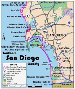
San Diego Section 7
La Jolla Shores Beach to Crystal Pier, Pacific Beach
This CCT route winds through the upscale, intensely developed La Jolla area. La Jolla, Spanish for "the jewel," resembles Palos Verdes Peninsula in Los Angeles in that it is part of a large urban area yet separated by both geography and affluence. La Jolla sits on a peninsula full of upscale houses approachable mostly on winding roads through the hills. The section starts and ends on beaches but mostly follows streets in between, with one stretch along a rugged shore and a visit to engaging Point La Jolla, which offers striking views of the rocky shoreline.
Start on broad La Jolla Shores Beach and walk south along the tideline down past the private La Jolla Beach and Tennis Club. Near the end of the beach at ⅜ mile, take the narrow unmarked walkway next to a restaurant up to Spindrift Drive. Turn right on Spindrift Drive and walk its sidewalk to Torrey Pines Road. Turn right and follow Torrey Pines two blocks, then turn right at ¾ mile and follow the little lane called Coast Walk to its end.
At the end of Coast Walk's pavement, take the dirt trail along the bluffs into the La Jolla Ecological Reserve, a 6000-acre reserve protecting the life in the tidal zone and submerged lands from the southern limits of Del Mar to Goldfish Point. It is illegal to disturb the wildlife in this area. The path yields stunning views of the wind- and sea-shaped cliffs of La Jolla Bay. The cliffs contain the seven wavecarved La Jolla Caves. After rounding a cove, the path heads northwest toward Goldfish Point. The path ends before 1¼ miles at a park on Coast Blvd. A stairway here leads down to the bluffs at Goldfish Point, from where you can climb down the rocks to tidepools.
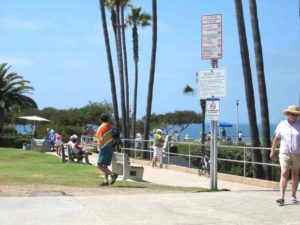
Turn right and walk the sidewalk of Coast Blvd. following the blufftop around the point above coves and beaches tucked in folded, convoluted sandstone bluffs. You come to bustling Ellen Browning Scripps Park at Point La Jolla beyond 1⅝ miles. Tourists take in the sights here while vendors sell jewelry and T-shirts from sidewalk tables. Follow the park path along the cliff edge beneath palms and wind-shaped Monterey cypresses. You pass La Jolla Cove and a path down to its popular, sheltered beach, then pass side trails to Boomer Beach and Shell Beach. Just beyond Scripps Park you pass a stairway to Children's Pool Beach, a fine beach partly shielded by breakwater. The beach is popular with families and often has sea lions residing on it.
Continue along the walkway above Seal Rock Point, then pick up the sidewalk along Coast Blvd. When you reach the narrow blufftop strip of Coast Boulevard Park at 2⅛ miles, you have a choice of routes. At lower tides CCT descends a path north of Cuvier Street to follow the scenic shoreline. See below for the street route.
The shoreline route makes its way over riprap, around rocky outcrops, and along the sandy cove of Nicholson Point Park to reach Marine Street Beach at 2¾ miles. Continue along this wide beach to its far end where stairs descend from Fern Street. Follow the shore over more rocks and around a small point to reach Windansea Beach around 3¼ miles, legendary as the beach in Tom Wolfe's first book, The Pump House Gang. Continue along the sandy beach of La Jolla Strand Park to its end where stairs ascend to Palomar Avenue at 3⅝ miles. The shore just down coast angles out to another unnamed point. While you can't walk the shore to the point, you can easily scramble over a low slickrock formation to reach a small sandy beach called Hermosa Terrace Park. From there you must climb a paved path to the end of Winamar Avenue on Camino de la Costa at 3¾ miles.
If the tide blocks walking the ocean's edge as described above, then continue on the Coast Blvd. sidewalk to Pearl Street. Turn left, then immediately go right on Olivetas Avenue for one block. Turn right on Marine Street and walk to its end where you will find access to its namesake beach. Turn left on Vista Del Mar along the bluff edge, then go right on Monte Vista to its end at Fern Glen. Turn right and walk Fern Glen to its end where there is access to Windansea Beach. The high tide route turns left on Neptune Place and follows it to the end where you go left on Palomar Avenue almost to its end opposite another path to Windansea Beach. A half block before the end of Palomar, turn left on Camino de la Costa. As you follow it south, in one block you pass the end of Winamar Avenue where the main route climbs from the beach.
The CCT continues down Camino de la Costa, rounding the unnamed point around 4 miles, then meeting stairs to the rocky shoreline at both Cortez Place and MiraMonte Place where de la Costa jogs left. At 4⅝ miles turn right and walk through tiny La Jolla Hermosa Park to Chelsea Avenue, walk Chelsea briefly, then go right to follow curving Dolphin Place. Here you'll find a small overlook park, and soon afterward stairs to the rocky beach at Sun Gold Point that descend from the end of short Bird Rock Avenue.
At the end of Dolphin Place, turn right on Chelsea Avenue, then immediately go right on Forward Street, then left on Calumet Avenue. Soon you reach Calumet Park overlooking the rocky shoreline. Follow Calumet Avenue out to Chelsea Avenue and turn right. When Chelsea ends at Wrelton Drive, turn left, then go right on La Jolla Blvd. for one block.
Turn right onto Tourmaline Street and walk through the parking lot for Tourmaline Surfing Park at 6 miles to return to the beach. Turn left at the tideline and walk the beach south beside descending bluffs, enjoying the sea air free of exhaust fumes. Head for historic Crystal Pier in the distance, passing through Palisades Park and into Pacific Beach Park to reach the pier and section's end at 6¾ miles.
SUGGESTED ROUND TRIPS AND LOOPS: Pick a low-tide day and make the shoreline walk from Point La Jolla to Windansea Beach and back for interesting geology and great scenery, 4 miles round trip. If the tides are just right you can continue from Windansea down to La Jolla Strand or Hermosa Terrace Park, adding another ¼ mile round trip. You can also make that 3¾-mile walk one way and ride the #34 bus back to the start.
Distance: 6¾ miles (10.9 kilometers).
Open to: Hikers. Bicyclists on streets.
Surface: Beach, trail, rocky tideline, sidewalk.
Access point: La Jolla Shores Beach.
How to get there: From Interstate 5, take the Ardath Road exit and head toward La Jolla. In about 1.4 miles turn right on La Jolla Shores Drive, then go left on Vallecitos Court and drive to its end at Kellogg Park.
Other access: Much of the route is on streets. Stairs or paths lead to the shore at Ellen Scripps Park, Coast Boulevard Park, Nicholson Point Park, Marine Street Beach, end of Fern Street, Windansea Beach, several along Camino de la Costa, Bird Rock Avenue, end of Linda Way, and end of Chelsea Place.
Difficulty: Easy
Elevation gain/loss: 200 feet+/200 feet-.
Cautions: Use caution on tidal rocks and don't get trapped by rising tides.
Further information: For the beaches along this route, call the San Diego Coastline Parks Division (619)221-8900.
Facilities: Water, restrooms, picnic tables and parking at La Jolla Shores Beach. Picnic tables, restrooms and water at Scripps Park and Tourmaline Surfing Park. Urban amenities in Pacific Beach.
Campgrounds: San Elijo State Beach at the start of Section 5 is the nearest, with 171 sites and hot showers. Reserve early.
Lodging: La Jolla has abundant accommodations mostly on the high end, with La Jolla Cove Suites and the Radisson Hotel the most affordable choices. Or try the Crystal Pier Motel in Pacific Beach at the end of this section. San Diego has two hostels, Point Loma (619)223-4778 and Downtown (619)525-1531.
Points of Interest

In the News
Interested in contributing to this project?
Register to add new photos and information, update existing results and share your trip reports.