
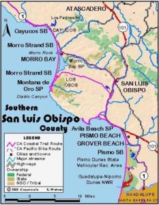
Usage Notes

Legend: For details on the icons and trail colors, please click the legend icon on the map above.

Layers: Other layers are available. See the California Coastal Commission and Coastal Conservancy Completed Sections layer for the official completed trail segments. (About progress on the trail completion project.)
San Luis Obispo Section 13
Oso Flaco Trail to Guadalupe Dunes Parking Lot
Oso Flaco Lake nestles in the heart of the Nipomo Dunes, a vast complex of sand hills stretching from Oceano south for 14 miles to Point Sal in northern Santa Barbara County. The dunes cover more than 18 square miles, the largest undeveloped coastal dune ecosystem in California. You've probably seen the Nipomo Dunes even if you've never visited them. A famous Ansel Adams photograph of the dunes was taken near Oceano and part of the 1920s version of the movie The Ten Commandments was filmed in the dunes. The immense Hollywood-style sets that were built for that epic lie buried somewhere in the vast dunes. To learn more about the Nipomo Dunes, read the adjacent feature and visit the Dunes Discovery Center on Highway 1 in Guadalupe.
Oso Flaco Lake, crossed by the access trail, is one of two lakes along lower Oso Flaco Creek, with a dozen more lakes scattered in the dunes in the three miles to the north. All the lakes provide important habitat for resident and migratory birds, and many unusual endemic plants grow around them. Oso Flaco Lake was named by the Portola expedition for the skinny bear they shot when camped here in 1769. The lean grizzly measured ten feet long but weighed only 375 pounds (typical grizzlies weigh 400 to 850 pounds). Still the bear fed 62 hungry men. Of course grizzlies no longer survive in California, but on my visit here saw fresh mountain lion tracks and two young coyotes who eyed me warily as they ran across the trail.
The Coastal Trail follows the tideline at the western edge of this vast eolian landscape. To reach the CCT from Oso Flaco Lake Road requires a hike of just over one mile (2⅛ miles round trip). When you reach the tideline there, you have the choice of walking north on Section 12 or south as described in this section.
From the access point either east of the entrance kiosk or just west of it, follow the narrow road northwest, soon passing the second gate and the only chemical toilets. Contour along the paved path through a marsh filled with willows. At ¼ mile the path crosses the northern neck of Oso Flaco Lake. Turn left in the middle of the crossing and follow the bridge/boardwalk across the lake. It soon turns right to head west. Leave the bridge and lake before ½ mile to contour west on a wooden boardwalk through vegetated dunes. By ¾ mile the boardwalk ahead IS closed. Veer right on a sandy path over a dune, affording your first good views of the surrounding dunes. The well-marked route soon returns to the boardwalk, which you follow west to its end around one mile. Continue west about 300 feet to the tideline, where you meet the CCT. Our mileage starts from zero here.
Follow the tideline south from the point west to the end of the boardwalk. Around ⅛ mile you may parallel a seasonal lagoon near the mouth of Oso Flaco Creek where it runs north to south. Cross the mouth of the creek, which was flowing into the Pacific on my February 1999 visit, at ¼ mile. Continue down the coast along the tideline with high vegetated dunes to your east.
Pass Coreopsis Hill around 1¼ miles, a prominent dune ridge lying about ¾ mile east where the giant Coreopsis of the sunflower family grows to eight feet, three feet taller than most individuals of the species. Beyond 1½ miles Oso Flaco Dune stands about ½ mile east, the highest dune this near the coast in the Guadalupe Dunes. Continue along the tideline, rounding a sandy point around 2⅜ miles.
By 3 miles two more high dunes rise to the east, the second dune, 176 feet, being about ¾ mile inland. Between 3 and 4 miles, the Guadalupe Oil Field lies in the dunes to the east. You may see several sandy vehicle tracks in this area, especially the southernmost two tracks between 4 and 4¼ miles where three small ponds nestle in the foredunes. No sign marks your passing into Santa Barbara County around 4¼ miles, but the high dunes give way to a low sandy swale with pockets of vegetation. This depression in the dunes marks the mouth of the Santa Maria River which flows seasonally out to sea around 4½ miles. Only after winter storms does the river offer any difficulty fording. The river's 365-acre wetland just inland from the mouth provides important bird and mammal habitat.
From around the river mouth, you may actually see cars driving over the dunes to the southeast. They follow the paved road that provides access to the Guadalupe entrance of Nipomo Dunes Preserve. This section ends at 5 miles as the tideline draws even with the Guadalupe parking lot at the end of that road. The paved parking area lies atop a rise about 200 feet east of the tideline.
SUGGESTED ROUND TRIPS & LOOPS: Walk the beach for as many miles as you choose in either direction, leaving enough time for your return hike unless you've planned a car shuttle. For a loop hike when the plovers aren't nesting, walk the beach south for up to 3 miles, follow the dune crest east for about a mile, then head north for Oso Flaco Lake. Be sure to take a map and compass.
Distance: 5 miles (CCT) plus one mile from access point (8.0 plus 1.6 kilometers).
Open to: Hikers. Wheelchair riders can navigate the first ¾ mile of access trail.
Surface: Beach for CCT. Dirt road, boardwalk, trail from parking area to beach.
Access point: Oso Flaco Lake Natural Area.
How to get there: Turn west off Highway 1 north of Guadalupe onto Oso Flaco Lake Road and go 3 miles to entrance kiosk. When kiosk is not staffed, you'll need to park on road shoulder 150 feet east. Do not block gate there.
Other access: None.
Difficulty: Easy
Elevation gain/loss: None for CCT. Trail from parking area to beach: 50 feet+/75 feet-.
Cautions: Open 6 am to 6 pm. No bikes, dogs, horses or fires. Watch for rogue waves when walking beach. Please stay out of plover nesting area from March through September 15. During that time stay on trail or on wet sand of beach and stay off upper beach and foredunes.
Further information: Oso Flaco Dunes Natural Area (805)473-7220, GuadalupeNipomo Dunes Preserve (805)343-2455.
Facilities: Wheelchair accessible chemical toilets at parking areas at both north and south ends of section.
Campgrounds: Pismo State Beach on Section 11 has 185 sites in two campgrounds.
Lodging: Arroyo Grande, Nipomo and Santa Maria have several choices. Bill's Home Hostel (805)929-3647 in nearby Nipomo is run by Bill Denneen, an expert on the ecology and history of the Nipomo Dunes. Another choice is Hostel Obispo (805)544-4678 in San Luis Obispo.
Points of Interest
No individual points found.
In the News
Interested in contributing to this project?
Register to add new photos and information, update existing results and share your trip reports.