
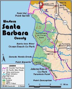
Usage Notes

Legend: For details on the icons and trail colors, please click the legend icon on the map above.

Layers: Other layers are available. See the California Coastal Commission and Coastal Conservancy Completed Sections layer for the official completed trail segments. (About progress on the trail completion project.)
Santa Barbara Section 1
Guadalupe Dunes, Nipomo Dunes Preserve, to Point Sal to Highway 1 at Brown Road
Looking south from the parking lot, an expansive beach ends abruptly at an immense high sand dune. Perhaps you'll rub your eyes in disbelief. While dunes are a familiar sight on the coast, the vast Guadalupe-Nipomo Dunes complex covers 18 square miles of southwestern San Luis Obispo County and northwestern Santa Barbara County. If you've been walking the Coastal Trail south from Pismo Beach, you've seen plenty of dunes, but the giant dune blocking the south end of the beach reaches an entirely different level.
In fact Mussel Rock Dune towers 480 feet above sea level, the west coast's highest dune. The CCT not only provides a closer look, it also climbs over the dune to interact with this unique feature, also the only way to get down coast to 1½-mile long Paradise Beach just beyond. If you keep pushing through the vast sandy landscape beyond Mussel Rock, you encounter Point Sal where the CCT route turns strenuous. There one must climb steeply to get onto Point Sal Ridge, another marvelous feature that ascends east to narrow Brown Road, the only way to continue down the coast. That's because vast Vandenberg Air Force Base occupies the next 35 restricted miles of shoreline. While the CCT follows a few miles of Vandenberg's coast, those miles do not include the 16 miles from Point Sal to Ocean Beach County Park west of Lompoc.
Whether you walk all of this section, best done with a car shuttle so it's a one way hike, plan to visit Mussel Rock Dune, Paradise Beach and Point Sal, among the most amazing places on the California coast. One can carry a backpack and camp on Paradise Beach, where water can usually be found in springs or creeks. Of course carrying a backpack here tips the scale, making it a strenuous trip.
From the parking lot at the end of the road, walk west about 200 feet to the tideline. Turn left and follow the tideline south toward Mussel Point at the seaward foot of the giant dune down the coast. You first follow a beach backed by low dunes to the east. Around one mile, where the shoreline cuts inland somewhat, the low dunes on your left give way to taller dunes, first to vegetated sand hills to 40 feet in height, then to taller, larger dunes. The high sandy rise of Mussel Rock Dune looms ever larger.
By 1½ miles the immense dune thoroughly dominates the view south. The steep slope above the tideline may have you wondering at the way through, while the mountain of sand rising to the east is also daunting. Watch carefully along the top of the beach at the dune's base for a bleached wooden T-shaped marker, the base and left arm of the T embedded in the dune. If it hasn't been obscured by drifting sand, it marks the easiest, most gradual route up onto the dune.
Alternately one can continue along the tideline, either as a side trip to see the fascinating rock formations at the dune's seaward base or for a more difficult CCT route. If you continue along the shore, beyond 13 miles the sandy beach is cut by fingers of rock protruding into the tidal zone. Walk up the beach slope to the dune's base and follow the top of the beach south, then a ledge atop the rocks. Be careful if you cross the rocks, very slippery in places. This route explores a fascinating area with seeps and black-sand pockets between the soft sandstone fingers, which have harder rocks and marine shells embedded in them. The easy walk ends before 2 miles, where it takes creative scrambling to continue. I learned the hard way when I stepped on - sloping dune only to find it underlaid with slick rock that sent me sliding ten feet down to the beach. If you get beyond that, a short stroll atop more rock fingers ends at a larger inlet at 2 miles. Cautiously pick your way around this inlet. After crossing slick rock on its far side, hop a waist-high ledge and find a vague path angling steeply east-southeast up the dune, the alternate CCT route south. (One might continue along the shore about ¼ mile, but it dead-ends.)
Back at the T guidepost, scramble about twenty feet up a slope of loose sand, then angle right to climb a more gradual slope of sand that's more firmly packed to reach an area stabilized by vegetation. Try not to step on plants as you find your way south, angling gradually up the dune. You won't find a trail unless someone came this way recently. Shifting sands on the dune's windward slope quickly cover any tracks, often within hours, certainly within days of anyone's passing. Stay off the steepest face of the dune down near the tideline, which may be undercut by sand cliffs not visible from here. At some point you'll need to traverse sidehill across steep slopes. Just be sure to keep climbing and not stray too close to the steep base of the dune near shore.
Beyond 2 miles you want to climb generally south-southwest, picking your way carefully across the sloping face of the giant dune. In places the dune is soft as silk, elsewhere it's hard as stone so take your time and watch where you're going. The lush pockets of vegetation perched on this giant sandhill may surprise you: fragrant lupine, beach strawberry, sand verbena, dune primrose plus several rare species.
By 2⅝ miles you want to be around 200 or 250 feet above sea level. Contour south ⅛ mile, then ascend steeply again to the main ridge of Mussel Rock Dune around 2¾ miles, elevation about 280 feet. The crest provides views down the steep northwest slope to an arched rock on a convoluted shore and south down coast to Paradise Beach and Point Sal. You might also pass Chumash shell middens atop the plateau on the dune's west slope.
To continue south on CCT to Paradise Beach, be sure you find a safe route down the dune. The preferred route descends a steep gully between two dune hills, winding down a vegetated slope to reach sandy Mussel Rock Dune Creek near its mouth. Once you get down to the creek, which flows out of a deep canyon, cross to the stream's south side and find the vague track that descends to Paradise Beach at its narrow north end around 3 miles.
CCT follows the tideline of Paradise Beach south. After quickly passing a rock outcrop, the beach broadens as it arcs toward vegetation-darkened Point Sal. It's a rare day you don't have this grand sweep of beach to yourself. Pass the broadest expanse of beach by 3½ miles, but the beach remains broad and backed by steep brushy slopes nearly to its south end. By 4¼ miles you pass a narrow spot on the beach before it fans out broadly again. By 4½ miles you'll see offshore rocks, then reach a double pronged covelet along the shore.
When you reach a long finger cove at 4⅝ miles, Point Sal is less than ¼ mile south, but the shoreline around the point does not offer safe passage. (To continue around the point to Point Sal Beach requires a low tide, walking narrow rock shelves, and climbing fifteen feet up an anchored rope to pass the final rock ledge.) CCT climbs southeast from the finger cove up a steep gully. Ascend the gully until you gain 200 feet elevation, where the slope eases. Contour south about ⅛ mile to where the odd plant giant coreopsis grows. As you go, watch on your left for a safe passage up onto Point Sal Ridge. You can climb southeast to gain knob on the ridgetop around 5 miles, or you can follow the gully to the northeast which has an obvious double track, an old jeep trail through loose sand. If you follow the double track, leave it for a sandy track that climbs steeply, heading due east up the ridge. Before 5¼ miles leave the sandy track for a grassy track climbing steeply due east.
When you gain the ridgetop, you want to climb east-northeast along its crest. As you ascend, enjoy the expanding vistas of this wilderness stretch of coast. On the way up you might also want to watch for the abundant pillow basalts, spheroid-shaped lavas created long ago beneath the Pacific, then brought up with this entire ridge by tectonic plate movement.
–
TO REMOVE GOOEY TAR: If you get tarred when walking a central coast beach, here's how to best remove the black goo. Scrape as much tar as possible from your feet (or shoes). Rub with mineral oil or cooking oil on a rag or paper towel to remove tar residue without using harsh solvents. Be sure to clean the oil off your feet before touching the carpet of your vehicle, home or lodging.
–
Climb steadily up the ridgetop, but not as steeply as the surrounding slopes, especially those to the south which drop precipitously to Point Sal Beach, an undeveloped state park. By 5¼ miles you gain 400 feet elevation. After a knob the track dips briefly then makes another steady ascent, gaining 800 feet elevation by 5⅝ miles where you again ascend steeply.
By 5¾ miles you approach a ridgetop knob 1010 feet in elevation. Veer right to follow a path that contours along the ridge's south face, enjoying amazing vistas down the wild Vandenberg coast to Honda Point and Point Arguello. Contour past a 1040-loot knob around 5⅞ miles, passing native beavertail cactus and hummingbird sage. Return to the ridgetop at a grassy saddle at 6⅛ miles and ascend the ridgetop east. Top a 1100-foot hill with a metal post at 6⅜ miles, then continue up the ridgetop to the 1205-foot summit at 6¾ miles. Follow the undulating ridgetop east-southeast, dipping to a saddle around 6⅞ miles before ascending a final 1200-foot crest beyond 7 miles. From there the track descends southeast, losing about 50 feet in elevation before meeting Brown Road at a big north-lacing bend beyond 7⅛ miles.
The CCT turns left to follow Brown Road as it winds generally east. (A right turn would descend to Point Sal Beach in about 2½ miles.) Brown Road ascends past an abandoned air force missile tracking station to this section's summit beyond 7¾ miles, 1260 feet. There the road turns north to leave Point Sal Ridge and descend into Corralitos Canyon. Drop by two switchbacks to cross the canyon's creek and come to a gate (locked on my May 1999 visit) at 9⅜ miles, just below the heart of historic Corralitos Ranch. The paved track continues, meeting the ranch road at 9½ miles, where you turn left on improved surface to descend steadily down the canyon. Descend to 400 feet by 10½ miles where the road and canyon turn east. Continue down Brown Road until the canyon broadens around 11¾ miles, then contour or descend gradually to Highway 1 and section's end at 13¼ miles.
ALTERNATE ROUTE: The only choice would be to stay on Highway 1 and miss this wondrous stretch of coast.
SUGGESTED ROUND TRIPS & LOOPS: Walk south from the Guadalupe Dunes lot, following the tideline to the rock fingers, or if you're careful and realize the dangers, all the way to the dead end at 2¼ miles and return. You can climb to the crest of Mussel Rock Dune for grand views, 5½ miles round trip, or continue to Paradise Beach, 6 miles or more round trip. Another choice is to park at the 4-mile gate or the 6.1mile point on Brown Road and walk down Point Sal Ridge to Paradise Beach. Or drive to the end of the rough road, if it's open, and descend the steep trail to Point Sal Beach.
Distance: 13¼ miles; 3 miles to Paradise Beach, 4⅞ miles to Point Sal, 7⅛ miles to Brown Road, then 6⅛ more miles to Highway 1 (21.3, 4.8, 7.8, 11.5, 9.9 kilometers).
Open to: Hikers. Bicyclists on road portion. Dogs OK south of Mussel Rock Dune
Surface: Beach, dunes, trail, road shoulder.
Access point: Guadalupe Dunes, Nipomo Dunes Preserve.
How to get there: Turn west off Highway 1 onto West Main Street at south end of town of Guadalupe. Follow Main 3 miles to entrance kiosk for Guadalupe-Nipomo Dunes Preserve, then continue 2 miles to parking at end of road.
Other access: Point Sal via Brown Road.
Difficulty: Moderate
Elevation gain/loss: 1660 feet+/1540 feet-. 280 feet+/280 feet- to Paradise Beach.
Cautions: Parking lot at access point open 6 a.m. to 8 p.m. No overnight parking. No dogs or vehicles allowed beyond the parking lot. No fires. Road to access point is occasionally closed by drifting sand, in which case you need to add the distance walked to parking lot at end of road. Dunes up from the beach are closed March to September to protect endangered birds during nesting season. Watch for rattlesnakes, ticks and scorpions, especially on Point Sal Ridge.
Further information: Guadalupe-Nipomo Dunes Preserve (805)343-2455.
Facilities: Chemical toilets at access point.
Campgrounds: Private Santa Maria Pines Campground in Santa Maria is the nearest. Oceano Campground in Pismo State Beach 19 miles north has 82 sites.
Lodging: Motels in Santa Maria 13 miles east. Bill's Home Hostel, (805)929-3647, in nearby Nipomo is run by Bill Denneen, an expert on the area's ecology and history. Bill may be willing to give a guided hike of the region. Another choice is Hostel Obispo in San Luis Obispo (805)544-4678.

Interested in contributing to this project?
Register to add new photos and information, update existing results and share your trip reports.