
Usage Notes

Legend: For details on the icons and trail colors, please click the legend icon on the map above.

Layers: Other layers are available. See the California Coastal Commission and Coastal Conservancy Completed Sections layer for the official completed trail segments. (About progress on the trail completion project.)
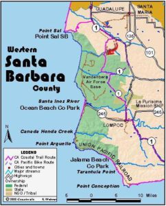
Santa Barbara Section 2
Highway 1 at Brown Road to Lompoc
Since Vandenberg Air Force Base occupies 35 miles along the coast south of Point Sal, the California Coastal Trail is forced to follow Highway 1 and rural roads to get south to the town of Lompoc (pronounced Lom-Poke). This long road section has no camping or lodging for nearly the entire route, making it problematic if you plan to hike through and don't want to do a 28-mile day. You'll actually reach the first lodging at Vandenberg Village 4⅝ miles north of downtown Lompoc, but the Spaceport Inn, which caters to NASA and other Vandenberg AFB visitors, is far more expensive than the budget motels in town. On the positive side, most of the section follows lightly traveled two-lane roads through ranch lands with pretty rolling hills dotted with oaks. Only the final 11 miles, which follows Highway 1, offers much traffic.
Walk the narrow shoulder of Highway 1 south from its intersection with Brown Road. The highway generally contours with agricultural fields on the left and the Casmalia Hills rising on the right. Climb an overpass to cross the main railroad line at one mile, then descend back to farm level with the tracks now on your right. As you contour down the highway, watch the tracks rising on your right. They soon turn south heading for Casmalia. The CCT soon does the same. Climb a gentle hill around 4 miles with views of the farms around Orcutt Creek, then contour or ascend slightly meet Black Road at 5½ miles.
CCT turns right and follows quiet, two-lane paved Black Road, climbing south. After crossing the railroad tracks at 7 miles, Black Road generally follows them south. After a short descent to 7¼ miles, resume climbing to 8⅛ miles, passing oil fields. Follow Black Road as it descends gently south down Shuman Canyon.
You reach Casmalia Junction at 9¼ miles. CCT continues straight, but a right turn on Point Sal Road leads to tiny Casmalia in ⅜ mile, which has a post office, store and steak house but little else. An amusing sign at the junction refers to Casmalia as the gateway to Point Sal-the road that goes through Casmalia on its way down Shuman Canyon, which like the railroad turns west here, has not gone through to Point Sal since the 1950s. Just beyond town, the road has a locked gate with grass growing in the roadway beyond it. The sign indicates how off the beaten track you are.
CCT climbs south from the junction on Lompoc-Casmalia Road, crossing the westbound tracks at 9⅝ miles, then dipping through a valley before ascending moderately through a corner of Vandenberg AFB. Climb through ranch lands, then across brushy slopes with scattered oaks to reach the section's summit at Bishop Road at 11 miles. Descend moderately along a pleasant oak-filled canyon beneath steep brushy slopes, passing Vandenberg's Titon Gate at 13 miles.
Beyond 13⅝ miles the road forks. If the right fork, Lompoc-Casmalia Road, has reopened, it offers the shortest route south, reaching the Vandenberg Main Gate at Highway 1 at 17⅞ miles. (At press time it was closed by a washout at San Antonio Creek.) Otherwise turn left at the fork and head east on San Antonio Road, gently ascending San Antonio Valley to reach Highway 1 at 16¾ miles. From there CCT heads south on the highway, climbing to a summit at Firefighter Road at 17½ miles, then descending to Vandenberg's Main Gate at 18⅞ miles.
CCT follows Highway 1 as it turns left and climbs slightly before descending a long hill to Santa Lucia Canyon at 22 miles. Continue on Highway 1, climbing to 22⅞ miles, descending to 23⅜ miles, then climbing briefly to the Vandenberg Village exit, which offers the first lodging on this section, beyond 23⅝ miles.
CCT continues down Highway 1, descending to 24¾ miles, then climbing briefly before descending again. Before 25⅝ miles the highway comes to a stoplight where you turn right to follow Highway 1 downhill into the town of Lompoc. After you cross the Santa Ynez River at 26⅜ miles, you pass the airport and pick up city sidewalks to take you downtown to section's end at Ocean Avenue at 27¾ miles. Highway 1 turns left on Ocean Avenue, the start of Santa Barbara Section 3, another long road walking section, the CCT's provisional route until Vandenberg Air Force Base gives up a route along the coast.
If you would like to visit and walk the Vandenberg coast in the interim, check out alternate Santa Barbara Sections 2A and 3A. While they don't offer a through route, they explore miles of wonderful shoreline.
ALTERNATE ROUTE: Perhaps your group can get permission from the Air Force for an escorted trip along the entire 35 miles of the Vandenberg coast like Coastwalk's Whole Hike did in 1996.
Distance: 27¾ miles (44.7 kilometers).
Open to: Hikers, bicyclists.
Surface: Highway shoulder, road shoulder, city sidewalks.
Access point: Highway 1 at Brown Road.
How to get there: On Highway about 2 miles south of Guadalupe, turn west on Brown Road and park on shoulder. Or from Highway 101 in Santa Maria, exit onto Main Street and drive west 9 miles to Highway 1, then drive Highway | south 1.8 miles to Brown Road.
Other access: Anywhere along route.
Difficulty: Moderate
Elevation gain/loss: 1575 feet+/1615 feet-.
Cautions: Stay out of roadway and on shoulder. Use extreme caution when crossing road.
Further information: Santa Barbara County Road Department (805)568-3094.
Facilities: None until Lompoc, except small store in Casmalia ⅜ mile off route.
Campgrounds: The nearest campground to north end is private Santa Maria Pines Campground in Santa Maria. Other than that, Oceano Campground in Pismo State Beach 19 miles north has 82 sites. Or try River Park, a private campground near Lompoc.
Lodging: Both Santa Maria and Lompoc have several motels, but you'll find nothing between the towns at either end of this long road walk. Bill's Home Hostel, (805)929-3647, 10 miles northeast of access point in Nipomo is run by Bill Denneen, an expert on area ecology and history.

Interested in contributing to this project?
Register to add new photos and information, update existing results and share your trip reports.