
Usage Notes

Legend: For details on the icons and trail colors, please click the legend icon on the map above.

Layers: Other layers are available. See the California Coastal Commission and Coastal Conservancy Completed Sections layer for the official completed trail segments. (About progress on the trail completion project.)
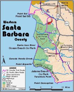
Santa Barbara Section 2A
Heart of Vandenberg Coast from Ocean Beach County Park
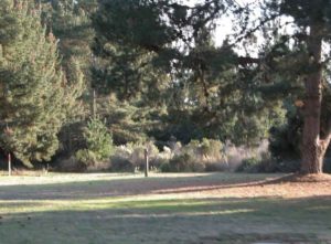
Here you can explore the heart of the Vandenberg coast, which consists of 35 miles of some of the wildest, most untouched beaches and rocky shorelines in the state. From the access point here at Ocean Beach County Park, you will see missile silos and other military installations up on the bluffs, but you won't see significant human-made intrusions on the beach and tidal zone except for the concrete seawalls built to protect the railroad right of way that follows the bluff edge along the southern half of the base. The wild coast provides important habitat for marine mammals and shore birds, which have lost so much of the rest of their California coastal habitat to development. Of course that means you're likely to see more marine wildlife when you hike here.
While most of Vandenberg Air Force Base is closed to public access for security reasons, the base does issue 50 day-use passes on weekends and holidays to explore other parts of the coast. These day use permits usually go to fishermen, but if you tell the game warden who issues the passes that you're here to look at or photograph marine wildlife, he'll probably give you pass. The a game warden's office is in building 13401 near the main base entrance on Highway 1 north of Lompoc, or call him at (805)606-1110, ext. 51275. If you get a pass, consider visiting Purisima Point to the north, where several miles of trails explore the bluffs south of the point with paths descending the bluffs to pocket beaches.
Even without obtaining the pass you can walk the intertidal zone from Ocean Beach County Park, heading north for up to 1¼ miles and south for up to 3½ miles. You can also explore Vandenberg's southern coast for up to 3¾ miles, described north from Jalama Beach County Park in Santa Barbara Section 3A. For any of these explorations, you want to avoid high tides and plan your trip to coincide with the tide ebbing to the lowest possible tide. The lower the tide, the more you're likely to see. You definitely do not want to explore here during particularly high tides and stormy weather. Under those conditions, you would see less and also might be forced to trespass up onto the bluffs, where you are subject to arrest by the military police.
Here at Ocean Beach, we'll describe the route south from the park, then the route north.
From the parking area at the end of the park road, follow the cement path under the train trestle and out to the beach where the pavement ends before ⅛ mile. Continue west on the loose sand to the tideline around ¼ mile, where the mouth of the Santa Ynez River is directly on your right. Turn left and follow the firm wet sand south along the tideline.
Walk a broad beach defined by the raised bed of the railroad. By ¾ mile you pass the Air Force community called Surf, perched on 50-foot bluff along the tracks. As you continue down the beach, the sloping bluffs soon rise to 80 feet in spots. By 1⅛ miles the tracks swing away from the beach. Continue south on the tideline passing three small canyons along the bluffs between 1⅝ and 1¾ miles.
By 2¾ miles the train tracks once again follow the top of the bluff. You may not notice them, however, since the bluffs now rise to 120 feet high. At 3⅛ miles where you pass the mouth of Bear Valley, which has extensive wetlands up from the tracks along Bear Creek, the bluffs rise to a towering 160 feet. You can continue along the beach below the high bluffs to a small point at 3½ miles, where the Air Force asks that you turn back. Above the high bluffs here, there is no level or gently sloping marine terrace. The land rises to an 887-foot peak about 1½ miles from the beach.
Walk back the way you came to Ocean Beach County Park.
To walk north from the Ocean Beach parking lot, you need to cross the mouth of the Santa Ynez River. This can be either extremely easy or a mild challenge. It's easiest in late summer and early autumn when the river stops flowing at the barrier beach. Then you can follow the trail from the park to the tideline and walk north with dry feet. In early summer, you may still be able to ford the shallow outlet of the river at its mouth, but at press time the river water and nearby ocean were signed "NO SWIMMING OR WADING -BACTERIAL CONTAMINATION." When the water is shallow and you have waterproof boots, you'll easily get across. When the contamination is cleared up, you'd be able to ford the river at its mouth in all but the wettest months. If you cannot cross the river at its mouth, the only way north (other than a boat) is to walk across the railroad trestle, then walk west along the river's bank to the tideline.
Whichever way you go, you'll be on the tideline north of the river mouth by ⅜ mile, where the beach swells to its widest point. Walk the broad, curving beach north. The beach narrows as you go. By one mile, the dunes to your east end, replaced by a 20-foot-tall bluff. As you continue north, the bluffs rise gradually higher. By 1⅛ miles the beach becomes quite narrow, perhaps impassable at high tide. Layered rock underlies the soil of the bluffs now with a few small caves adding interest.
By 1¼ mile you reach a big arched rock blocking the beach. An inconspicuous sign atop it warns that this is the end of public access. The arch provides an intriguing view of the rocky shore to the north. Even if you have a day-use pass from the base's game warden, you couldn't walk far beyond the arched rock, and even then only at low tide. If you have a pass, walk back south about ⅛ mile and find a path up onto the bluffs. With your pass you can walk north along the bluff's edge or on the road just inland. By 3⅝ miles the road peters out as it enters extensive sand dunes, but one can continue along the west face of the dunes above the convoluted rocky shore until you reach Purisima Point around 5⅝ miles. However far you walk, you must return to Ocean Beach County Park since the CCT has no through route along the coast.
SUGGESTED ROUND TRIPS & LOOPS: Walk the beach north or south as described and return the way you came.
Distance: 4¾ miles total one way (9½ miles round trip), up to 1¼ miles north and up to 3½ miles south. With a weekend day-use pass you can walk up to 5⅝ miles north (7.6, 15.3, 2.0, 5.6, 9.1 kilometers).
Open to: Hikers, dogs. Bicyclists on road from Lompoc to park.
Surface: Paved trail, beach.
Access point: Ocean Beach County Park.
How to get there: From Highway in downtown Lompoc, head west on Ocean Avenue for 8.4 nearly level miles, then turn right on road marked "Ocean Beach" and go one mile to parking at end of road.
Other access: None.
Difficulty: Easy
Elevation gain/loss: Negligible.
Cautions: Park open 8 a.m. to sunset. Portions of the park's sand dunes above the beach may be closed from March through September to protect nesting least terns, an endangered shore bird. You are not allowed on the bluffs of Vandenberg Air Force Base, outside of the County Park, without written permission from VAFB. No swimming or wading on beach due to bacterial contamination.
Further information: Ocean Beach County Park (805)934-6148.
Facilities: Restrooms, water, picnic area at Ocean Beach County Park.
Campgrounds: River Park, a private campground on the Santa Ynez River east of Lompoc has 34 RV units plus a large open area for tenters.
Lodging: Many economical motels in Lompoc.

Interested in contributing to this project?
Register to add new photos and information, update existing results and share your trip reports.