
Usage Notes

Legend: For details on the icons and trail colors, please click the legend icon on the map above.

Layers: Other layers are available. See the California Coastal Commission and Coastal Conservancy Completed Sections layer for the official completed trail segments. (About progress on the trail completion project.)
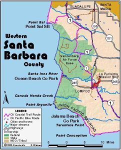
Santa Barbara Section 3
Lompoc to Gaviota State Park Pier via Highway 1
The shoreline here continues to have very limited access due to the combination of Vandenberg Air Force Base and large private ranches north and east of Point Conception. You have the opportunity to walk some of this remote, spectacular coast from Ocean Beach County Park as described in Section 2A and Jalama Beach County Park as described in Section 3A, but if you're through-hiking the CCT, you'll need to follow this section's route to get through, whether or not you detour to explore the dead-end routes along the coast.
Head east along the sidewalk of Ocean Avenue (also Highways 1 and 246) from its corner with H Street, walking through a mostly abandoned commercial district, then through a newer neighborhood of malls and eating establishments. By the time you reach Seventh Street at one mile, you'll see enough room to fly kites beside this main drag. Follow Highway 1 as it veers left towards the eastern city limit.
Beyond 1¼ miles the road forks. Highway 246 continues straight, soon crossing the Santa Ynez River and coming to River Park Campground on the left in ¾ mile. At the highway intersection, CCT turns right to follow Highway 1 south. Follow the two-lane road, with city sidewalks soon replaced by broad shoulders as you ascend into coastal hills, a lovely lush green in a spring replaced by golden brown in summer. By 2¾ miles you reach the first summit, where Santa Rosa Road forks left.
CCT continues along Highway 1, descending slightly to 3⅜ miles, then contouring beside passing lanes before climbing gently to a second summit at 3⅞ miles. After a slight descent to 4¾ miles, ascend gradually along the highway shoulder as it follows the canyon of Salsipuedes Creek. Cross the creek at 5 miles and climb slightly to the turnoff on the right for Jalama Road at 5⅝ miles. Jalama Road leads 14 miles to Jalama Beach County Park on the other side of the Santa Ynez Range. See Section 3A for coastal access there.
CCT's provisional highway route continues along Highway 1, descending east to 6¾ miles, then climbing fitfully along El Jaro Creek. After crossing the creek beyond 7¼ miles, descend briefly, then climb to 7¾ miles before dropping to cross El Jaro Creek again at 9⅜ miles. Ascend gently along the highway as it follows El Jaro Creek Canyon, crossing Ytias Creek at 10½ miles, then El Jaro Creek again. The highway contours or climbs gradually to its final crossing of El Jaro Creek at 15 miles. Contour east to 15½ miles, then climb to the section's summit at 16⅝ miles.
From the summit you descend a long steady hill to 19½ miles where Highway 1 joins Highway 101 as it descends from nearby Nojoqui Pass. Turn right and cautiously walk single file down the shoulder of the busy combined highways. Around 21⅜ miles you'll want to veer off the busy road and walk through the rest area for a short break from speeding traffic.
When you return to the highway shoulder, you only have a short walk downhill to the turnoff for Gaviota State Park at 22 miles. Turn right and walk down the park entrance road, crossing Gaviota Creek and coming to the park's entrance kiosk at 22⅜ miles. If you're camping here, take the first left beyond the kiosk.
Otherwise continue straight through the day-use parking lot to the end of the pavement and section's end at 22½ miles. The next section starts here near the Gaviota Pier and follows the tideline down the coast, which actually runs east from here to the Santa Barbara/Ventura County line.
ALTERNATE ROUTE: None unless you can get permission to walk the coast through the privately owned Bixby and Hollister Ranches from Point Conception to Gaviota.
Distance: 22½ miles (36.2 kilometers).
Open to: Hikers. Bicyclists on road portion.
Surface: Highway shoulder, sidewalk.
Access point: Downtown Lompoc, Ocean Avenue and H Street, where Highway makes a 90-degree turn.
How to get there: Drive Highway to Lompoc's downtown area, where the highway turns from north-south on H Street to east-west on Ocean Avenue.
Other access: Anywhere along route.
Difficulty: Moderate
Elevation gain/loss: 1370 feet+/1450 feet-.
Cautions: Wear bright clothes, walk single file and be careful on this highway route.
Further information: None.
Facilities: City services near access point. The rest area one mile before section's end and Gaviota State Park have restrooms, water, phone and picnic tables.
Campgrounds: River Park, a private campground only a mile off the route on the Santa Ynez River east of Lompoc has 34 RV units plus a large open area for tenters. Gaviota State Park has 55 units available on a first come, first serve basis.
Lodging: Lompoc has many choices.
Points of Interest
No individual points found.
In the News
Interested in contributing to this project?
Register to add new photos and information, update existing results and share your trip reports.