
Usage Notes

Legend: For details on the icons and trail colors, please click the legend icon on the map above.

Layers: Other layers are available. See the California Coastal Commission and Coastal Conservancy Completed Sections layer for the official completed trail segments. (About progress on the trail completion project.)
Santa Barbara Section 3A
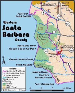
Southern Vandenberg Coast and Point Conception from Jalama
The popular campground at Jalama Beach draws enthusiastic visitors nearly year round despite chilly winters, often foggy summers and cool coastal breezes most of the year. The park's gorgeous setting gets overwhelmed by the crowds at times, but it's a pleasant place even if rowdy on weekends. The real treasure here is the near wilderness quality of the shoreline extending north and south. Very few people walk north more than ½ mile even though a medium-low tide allows passage up the rugged shore of the Vandenberg coast for up to 3¾ miles. Given the appropriately low tides, a few adventuresome souls walk the shoreline south just for the chance to get near Point Conception, the otherwise inaccessible point where the California coast makes an amazing dogleg turn east. The land at Point Conception is a Coast Guard Reservation, but unlike some lighthouses and their reservations, visitors are not allowed there. This entails more than just a government regulation. The Chumash people consider Point Conception the "Western Gate." The Chumash believe that all land visible from the point is sacred, and that disaster will befall anyone who disturbs the land. Thus they asked the Coast Guard to restrict access.
We highly recommend both the beach walks north and south from Jalama Creek, but you need to be aware that, while tideline walking is allowed, you can be arrested for trespassing on the bluffs of Vandenberg Air Force Base. The wild hills and bluffs south and east of Jalama Park are all part of the huge Bixby Ranch, a privately owned ranch dating back to the 19th century. Ranch hands for the Bixby don't appreciate trespassers either. Some of these ornery cowpokes have been known to rough up those who ignore the fences and private property. So be sure to schedule your hike(s) with the appropriate low tides. First we'll describe the hike north, then the walk south.
From the north end of the Jalama Park day-use parking lot, walk west to the tideline and head north along the damp sand. You soon pass the mouth of Jalama Creek, which may require a ford during the wet season. Before ¼ mile the bluffs rise 30 feet on your right. The point here may not be passable at the highest tides. Be sure you have a receding tide low enough to continue.
By ½ mile you pass rocks and tar deposits littering the tidal zone as the sheer bluffs rise 50 feet. Pass a cave in the cliff around ⅝ mile. At ⅞ mile a steep narrow gully cuts through the 80-foot-high unstable cliff. The beach is broad here but narrows to a rocky shelf beyond one mile. Pick your way carefully along the rocky shelf to 1⅛ miles.
Follow another sandy beach, then a rocky beach, with gullies bisecting the bluffs above and towering Espada Bluff looming ahead. Around 1¼ miles your route requires scrambling around a rocky point, with the roughest passage lying at the very point before 1⅜ miles. Walk north on the narrow rocky beach littered with abalone and spiny lobster shells, enjoying the views toward shovel-head shaped Espada Bluff ahead. When you reach Espada, you won't be able to see it towering overhead.
Beyond 1½ miles you need to scramble around a double point beneath an 80 foot-high bluff. While the first point is easy, the second, marked by a small rock arch at tideline, offers the roughest passage yet on this section. Still, you'll find a vague footpath here. Amidst this scramble you meet the steep narrow gully of Long Horn Canyon where escaped celery, watercress and fennel crowd the stream along with native mallow and sunflower. The canyon features a double waterfall when its stream is flowing.
By 1⅝ miles you can see the railroad line above. Drop to a narrow beach and follow it north, soon leading to more rock scrambling. By 1¾ miles you reach a seawall that shields the rail line from powerful wave action. Walk the top of the seawall along the base of Espada Bluff which towers 378 feet only ⅛ mile from the beach. From there the steep slopes rise to 2014-foot Oak Mountain 2 miles from the beach.
The seawall, dated 1923, ends at 2 miles, passing a raised culvert. To continue you must scramble around another point. Your passage is easy until the narrow spot at the point itself around 2⅛ miles, where you'll need a tide of +3.5 feet to get through. Walking turns easy again on low-tide sand or rock shelves above. Espada Bluff ends before 2¼ miles where a gully cuts through a 40-foot cliff above the beach. If you can continue, you reach another sandy beach by 2⅜ miles, backed by low bluffs. Walk it to a sandy point at 2⅝ miles where Canada del Jolloru has cut a broad path to the sea, then continue along the sand until it ends around 3 miles. The railroad siding called Sudden, named for the family that ranched here for generations, perches 90 feet overhead on the marine terrace above the bluffs.
If the tide is low or receding, you can continue along the tideline by rock scrambling. If you go, you'll pass the mouth of Sudden Canyon at 3⅛ miles. By 3½ miles, where you pass another deep unnamed canyon, you're once again able to walk a sandy beach. Follow it to the low sandy point at 3¾ miles, where you are asked to turn back and return the way you came. If the weather is clear enough on your way back to Jalama Beach, enjoy the long vistas down the coast to the high bluff of Point Conception.
From the Jalama Park day-use parking lot, walk west to the tideline and head south. By ¼ mile the bluffs rise 40 feet on your left. Follow the sandy beach toward the nearby point, passing a few rocks at tideline around ⅜ mile, then a small seasonal creek that cascades down the rock shelf of the bluff in winter and spring. Pass another seasonal stream beyond ⅝ mile, then a cross atop the bluff. An arroyo at ⅞ mile has a small waterfall during the wet season.
At one mile you round the point that has limited your view down the coast and encounter a broad rock shelf extending into the low tide zone. You also gain a view of Point Conception and its lighthouse to the south. The bluffs rise 100 feet on your left. Continue south, rounding a secondary point at 1⅛ miles.
Beyond the second point, walk the sandy beach around a shallow curving bay. a At an arroyo beyond 1½ miles, you can see the railroad tracks 160 feet above. Round a small rocky point at 1⅝ miles that marks the end of the bay. Most of your walking here follows rock shelves where you probably could not get by at high tide. Curving rock strata shape the cliffs on your left.
By 1¾ miles your walking again turns easy along a sandy beach. Around 1⅞ miles you pass the first seawall south of Jalama, with unstable sloping bluffs above it. You cannot see the Point Conception Lighthouse beyond this point. Soon the tidal zone features mostly level stratified rock shelves. By 2⅛ miles you reach the second seawall and a small cascade that drops down the high bluff. Reach the third seawall at 2¼ miles. At higher tides you may need to walk above it to get down the beach. That seawall ends beyond 2⅜ miles.
Around 2½ miles you pass the final seawall before Point Conception. An old wooden flume here carries a seasonal creek jammed with mimulus to the beach. From here the railway line angles inland and the sandy beach offers easy walking. Pass Black Canyon around 3 miles, notable as the only named canyon on this stretch of coast and the last place you see the train tracks from the beach. After a nameless canyon at 3⅜ miles, you head straight down the beach toward the point. Pass a steep canyon at 3⅝ miles that descends from Las Animas Spring. At 3⅞ miles you reach a deep dry canyon that sits just north of a rocky ledge. A ranch road runs from near the mouth of the canyon up onto the headlands, but you're not supposed to use it since it sits on private property. If the tide allows you to continue along the shore, scramble over the tarry rock ledge called Perch Rock and continue south on the beach.
From 4 miles you must have a tide of 0 feet or lower to continue. Even then you'll need to walk on slippery seaweed-covered rocks (or make a difficult rock scramble over a protruding bluff) to continue south. It's only about 200 feet to the next beach, essentially the final accessible beach before the impassable cliffs of Point Conception. That beach continues almost ⅜ mile before ending with vistas of the nearby 200-foot cliffs of Point Conception and its inaccessible Coast Guard Reservation. This final beach has an emergency escape route if rising tides cut you off. You'll find the vague emergency track climbing the steep bluffs at 4⅛ miles, but since it puts you on private property try not to use it and instead retrace your steps to Jalama Beach.
SUGGESTED ROUND TRIPS & LOOPS: Walk the beach north or south for as long as time and tides allow.
Distance: 8⅛ miles total one way (16¼ miles round trip), up to 3¾ miles north and up to 4⅜ miles south (13.1, 26.2, 6.0, 7.0 kilometers).
Open to: Hikers, leashed dogs OK on beach. Bicyclists on road to Jalama.
Surface: Beach, rocky shore.
Access point: Jalama Beach County Park.
How to get there: Turn west off Highway about 5.5 miles south of downtown Lompoc onto Jalama Road. Drive 14.3 miles to county park at end.
Other access: None.
Difficulty: Moderate
Elevation gain/loss: Negligible.
Cautions: Stay along the tideline and off adjacent private and Air Force Base property. Hike north requires a tide lower than +3.5 feet. Hike south requires progressively lower tides for each mile you walk. Watch for dangerous surf and rogue waves.
Further information: Jalama Beach County Park (805)736-3504.
Facilities: Restrooms, water, picnic area, phone, small store at access point.
Campgrounds: Jalama Beach County Park has 10 sites available on a first come, first serve basis. A few group sites can be reserved in advance.
Lodging: Lompoc has the nearest lodging.
Points of Interest
No individual points found.
In the News
Interested in contributing to this project?
Register to add new photos and information, update existing results and share your trip reports.