
Usage Notes

Legend: For details on the icons and trail colors, please click the legend icon on the map above.

Layers: Other layers are available. See the California Coastal Commission and Coastal Conservancy Completed Sections layer for the official completed trail segments. (About progress on the trail completion project.)
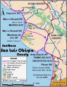
San Luis Obispo Section 12
Pismo Beach Pier to Oso Flaco Trail
Around Pismo Beach the CCT through hiker heading from north to south once again encounters a vast accumulation of sand, in fact more sand than has been seen since the shores of Monterey Bay. This sandy world extends all the way to Point Sal in northern Santa Barbara County without interruption and sets the tone for most of the shoreline to the south. The Pismo Dunes are followed by the vast Nipomo Dunes, the second largest collection (after the Oregon Dunes) of sand on the west coast of North America.
The bad news for hikers here is that vehicles are allowed on the beach from Grover Beach south for five miles, almost to the end of the section. While CCT hikers in Humboldt and Del Norte Counties may have encountered a few vehicles driving the beach, here the off-roaders congregate in alarming numbers, ironically compressing and denuding a fragile environment. Let it suffice to say that this is not our favorite part of the Coastal Trail, although it would offer delightful hiking if the State of California would take the brave stand of closing this ORV amusement park. We do recommend the Suggested Loop at the end of this section. There you'll experience enough vehicles on the beach to get the picture, then be able to leave them behind as you loop back through dunes and along wetlands fortunately protected from the onslaught of internal combustion engines.
The name Pismo comes from the Chumash word pismu, meaning the asphaltum tar that leaks from natural fissures in the ground or sea floor along the central California coast. The Chumash used the tar to make their baskets and pine plank canoes waterproof. Here in the Pismo Beach area CCT through hikers will likely see the first gooey balls of tar on the beach. The town of Pismo Beach first became a popular summer vacation destination shortly after it was founded in 1891. Then the Pismo clam for which the area is also famous was so abundant that farmers fed them to their animals after harvesting them by plowing the beach. Now the clam is scarce enough that it's usually found by experienced clam diggers only at low tide.
Unless you are continuing along the CCT from the previous section, make your way from the parking lot to the beach at the foot of the pier. The CCT heads south along the tideline of the broad beach, a busy and popular place on a sunny day. When the weather is clear you look south across San Luis Obispo Bay to Mussel Rock Dune and Point Sal.
Alternately you can walk south from the pier's access way across the concrete plaza, then follow the raised wooden boardwalk along the beach front. It turns to concrete as it passes the Sandcastle Inn. Then you can take the stairs or ramp that descend to the beach and follow the tideline south, or cross the cul-de-sac and walk sidewalk and parking lot south to the development's abrupt end at ¼ mile.
Either way you go, follow the tideline beyond ¼ mile, with the wetlands near the mouth of Pismo Creek to your east. When you cross the seasonally flowing mouth of the creek at ⅜ mile, the state beach's North Beach Campground lies to the east. Soon the broad beach narrows where the trees of the campground extend west. Immediately south of the campground at ⅝ mile, the second of two beach access trails heads east. The easiest CCT route continues along the tideline, but you can also walk the trail east 1000 feet, then turn south and follow the Meadow Creek Trail to its south end, cross Grand Avenue and continue south on the Grand Dunes Trail, which ends at Oceano Campground around 2 miles where you need to head west to return to the tideline.
The tideline route passes the end of Grand Avenue before 1¼ miles. Street legal vehicles are allowed on the beach south from here for the next 2 miles, with off-highway vehicles permitted from there south almost to the end of this section. As you follow the shore south, dunes of increasing height lie to the east between the tideline and Meadow Creek which parallels the shore. Pass the highest of these dunes, about 55 feet, around 1¾ miles. Continue down coast on the tideline, with Oceano Campground on the west shore of Oceano Lagoon lying to the east beyond 2 miles.
At 2⅜ miles you reach the end of Pier Avenue, the main access for Oceano Dunes State Vehicular Recreation Area (SVRA). You'll find restrooms not far to the east here. We highly recommend you wear bright clothing if you walk south from here. As you walk the tideline south, cross the mouth of Arroyo Grande Creek around 2⅝ miles. While the tideline still offers the firmest footing, on busy days in the SVRA the tideline south from here seems more like a highway than a beach. Consider following the south shore of the creek east for about 400 feet into the Pismo Dunes Natural Preserve where vehicles are not allowed. There you can walk south through the dunes (soft sand, slow going) to the preserve boundary around 4 miles. You pass through the site of the Dunite's village there(read the feature The Amazing Nipomo Dunes), then return to the tideline.
From 4 miles the vehicle traffic starts to thin out since off-road vehicles are also allowed in the dunes east of the beach and street legal vehicles are not allowed at all. Between 4 and 5½ miles, several lakes nestle in the dunes about a mile east of the tideline, but you can't see them because of the 100-foot-high dune ridge about ⅝ mile east. The dunes in this area have a flat, compressed appearance because of the extensive vehicle traffic, which also destroys virtually all of their stabilizing vegetation. A few fenced enclaves with isolated green foliage only reinforce this contrast.
CCT continues south along the tideline. Around 6¼ miles a large sign proclaims a 15 mph speed limit. At 6½ miles you reach the metal fence that marks the southern end of the SVRA. Pass the fence and walk the tideline for another ½ mile to a spot where the high dune ridge to the east has a ¾-mile a gap. Watch on your left for the Oso Flaco Trail, a boardwalk that climbs east into the dunes. The boardwalk marks this section's end and the beginning of the next. The side trail leads one mile to the end of Oso Flaco Lake Road. If you miss the boardwalk, you might see the small lagoon near the mouth of Oso Flaco Creek, though it may dry up in the dry season.
ALTERNATE ROUTE: Several choices included in trail report give you options for avoiding the vehicle traffic that mars the experience of walking this stretch of beach.
SUGGESTED ROUND TRIPS & LOOPS: Walk the beach to Pier Avenue, head east to Oceano Campground, then return by walking north through the campground or along the Oceano Lagoon Trail, continuing on the Grand Dunes Trail to Grand Avenue, then the Meadow Creek Trail to its north end. From there you head west to return to the beach for the final leg north, although in winter you might consider a side trip ¼ mile east into the grove of eucalyptus trees that are the winter home of thousands of monarch butterflies.
Distance: 7¼ miles (11.7 kilometers).
Open to: Hikers. Dogs OK on leash on State Beach, not allowed on Nature Conservancy lands.
Surface: Beach, dunes, trail.
Access point: Pismo Beach Pier.
How to get there: From Highway 101 in Pismo Beach, exit Hinds Avenue southbound or Price Street northbound. Go west on Hinds Avenue to parking near pier at end.
Other access: Ends of Grand Avenue and Pier Avenue.
Difficulty: Easy
Elevation gain/loss: Negligible.
Cautions: Watch for rogue waves on beach. From Grand Avenue around 1¼ miles south, most of this section is open to motor vehicles. Try not to hike through the State Vehicular Recreation Area there on a weekend, and wear bright clothing when you go.
Further information: Pismo State Beach (805)489-1869, Oceano Dunes State Vehicular Recreation Area (805)473-7220
Facilities: Restrooms, water and phones at access point, with town services, groceries, food, body adornment-available to east. Restrooms and water at North Beach Campground, Oceano Campground and near the end of Pier Avenue.
Campgrounds: Pismo State Beach has 103 sites in North Beach Campground and 82 sites in Oceano Campground.
Lodging: Many choices in the Five Cities area--Shell Beach, Pismo Beach, Grover Beach, Oceano and Arroyo Grande. Hostel Obispo (805)544-4678 is in San Luis Obispo. Bill's Home Hostel (805)929-3647 is in the town of Nipomo 9 miles east of south end.
Points of Interest

In the News
Interested in contributing to this project?
Register to add new photos and information, update existing results and share your trip reports.