
Usage Notes

Legend: For details on the icons and trail colors, please click the legend icon on the map above.

Layers: Other layers are available. See the California Coastal Commission and Coastal Conservancy Completed Sections layer for the official completed trail segments. (About progress on the trail completion project.)
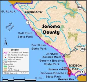
Sonoma Section 7
Blind Beach Trailhead to Salmon Creek, Sonoma Coast State Beach
Here the CCT offers a great combination of views, wildflowers, rocky tidal areas, and short sandy beaches. From the Blind Beach Trailhead 200 feet above the beach, you can see north to Jenner, the Russian River mouth, and Salt Point.
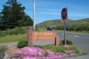
From the parking area, walk south 300 feet to the Kortum Trail. Follow it down through a broad swale then up to a notch between two hills at ¼ mile. The view opens out to the marine terraces with Bodega Head ten miles south and Point Reyes beyond. For even better views, take the short spur west to Peaked Hill. The trail descends east and south to the tabletop flat marine terrace. At ⅝ mile you pass a huge rock outcrop used regularly for rock climbing. This rock was a sea stack jutting from the ocean, just like the ones offshore now, before being drylanded by the rising wave-cut terrace. The trail follows the bluff's edge past more sea stacks both on and offshore. At one mile it cuts inland to wind through a gully. Continue across the level terrace, jogging east to cross a bridge over a creek at 1½ miles. Return to bluff's edge and follow it to Shell Beach at 1⅞ miles. A short side trail on the right deadends at rocky Shell Beach.
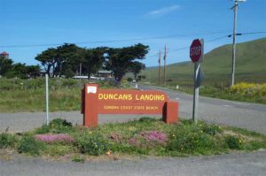
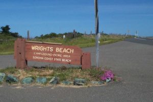
Cross the parking area to find the trail south. It crosses a bridge over a creek to traverse headlands with thick coastal scrub. During spring and summer wildflowers bloom profusely here. After following the bluff's edge, the trail turns east and crosses a bridge over another gully. Traverse the headlands until 2⅜ miles where the trail drops into Furlong Gulch to cross its creek. A dark sand beach lies at its mouth. CCT climbs out of the gulch to follow the bluff edge. The trail soon turns inland to a paved road end at 2⅞ miles, one of several roads built for a subdivision halted by coastal advocates, who saved this beautiful area for public use. Head south across a bridge over a gully and veer toward the bluff. At 3 miles the trail drops to Wrights Beach. Walk the sand south past a campground, picnic area and restrooms around 3¾ miles. Continue along the beach, which ends before 4¼ miles at Death Rock, so named because of huge waves that sometimes break over the rocks and wash people into the dangerous, sometimes deadly surf. Climb the trail to Duncan's Point and follow the one lane road circling around the point. On the south side a trail drops to a small beach and protected cove, but even at low tide you cannot walk the tideline to Portuguese Beach. The Coastal Trail reaches Highway 1 at 4⅝ miles. From here to section's end, the road hugs the blufftop, with trails dropping to the beach in several places. At low tide you can explore the rocky tidal zone, but beware of large waves.
Continue south on the narrow highway shoulder, watching for places to walk off the shoulder. After passing houses hanging precariously on the cliff (as of this writing three of them are starting to slip off), the road descends to Portuguese Beach at 5½ miles. Walk this short beach for almost ½ mile, then climb a trail to a point before 6 miles. Just across the point is Schoolhouse Beach. Since there's no safe way down, walk the highway past the vacation subdivision of Carmet. Around 6½ miles an unmarked but official trail descends to the rocks 40 feet below. You can take this route ¼ mile before coming back to the road, or just stay on the road. At 7 miles look for a trail down to rocky Coleman Beach. You can usually walk from here onto Salmon Creek Beach. If the tide is too high, continue on the road. Either way, walk to the mouth of Salmon Creek at 7½ miles where a parking lot and outhouse are on the bluff near a short trail to the beach.
SUGGESTED ROUND TRIPS G LOOPS: From Shell Beach walk the Pomo Trail over the ridge to Pomo Campground, then loop back to Highway I on one-lane, lightly used Willow Creek Road. Walk the highway south to Goat Rock Road, turn right and follow it to the Blind Beach Trailhead, then take the Kortum Trail south to Shell Beach, a loop of 8 miles. A good 4-mile round trip hike from Shell Beach takes Pomo Trail to Pomo Campground and back. From Shell Beach explore the coastal terrace, 4 miles round trip either north or south.
Distance: 7 ½ miles (12.1 kilometers)
Open to: Hikers, bicyclists
Surface: Trail, beach, tidal rocks, highway shoulder
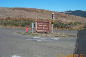
Access point: Blind Beach Trailhead
How to get there: From the junction of Highway 116 (River Road) and Highway 1, go south one mile to Goat Rock Road. Follow it west .5 mile to the trailhead.
Other access: Shell beach, many parking spots along Highway 1.
Difficulty: Easy
Elevation gain/loss: 280 feet +/480 feet-
Cautions: Watch for dangerous surf and highway traffic.
Further information:
Facilities: Chemical toilet at access point, Shell Beach and Salmon Creek. Restrooms, picnic area and water at Wrights Beach.
Campgrounds: Willow Creek and Pomo walk-in Campgrounds are just east. Wrights Beach Campground is on route.
Lodging: Bodega Bay has lodges, motels and B&Bs. Click the button below to visit Sonoma County's Tourism website to find more information on places to stay. More Info


Points of Interest
In the News
Interested in contributing to this project?
Register to add new photos and information, update existing results and share your trip reports.