
Usage Notes

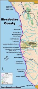
Legend: For details on the icons and trail colors, please click the legend icon on the map above.

Layers: Other layers are available. See the California Coastal Commission and Coastal Conservancy Completed Sections layer for the official completed trail segments. (About progress on the trail completion project.)
Mendocino Section 3
Usal, Sinkyone Wilderness State Park, to Highway 1 at Usal Road
The section of Usal Road shared by the CCT is one of the most spectacular trail sections open to motorized traffic. The dramatic ascent from Usal and the high middle section before the summit provide vistas as stunning as those on the Lost Coast portion of CCT, even though they are not quite as pristine due to continued logging activity. Why walk this section when you can drive it? Because the views of the coast and the adjacent rugged terrain are continually inspiring, much more so than when you're enclosed in a vehicle.
From the Lost Coast Trailhead, follow level Usal Road south over the Usal Creek bridge and out of the campground. After passing the side canyon called Shady Dell at ⅜ mile, the road ascends steeply southwest, leaving the park at the first hairpin turn where a bird's-eye view of Usal and the rugged coast north to Big White Rock may steal your breath if the hill hasn't already. Continue the steep climb up the hairpins, watching and listening for traffic. The track skirts the edge of the forest with sheer grasslands to the west.
The ascent iS unrelenting until 2 miles where you have gained an elevation of 1060 feet and left the grasslands for forest. Road and trail descend briefly, then contour with frequent views of the coast far below. Climb slightly around 2¾ miles, then descend into grasslands at the top of a steep slope plunging to the sea. Climb moderately from 3¼ miles until you reach the section's 1100-foot summit in the forest around 3¾ miles. After a brief descent, your road contours through timber lands until 4¼ miles. Descend gradually to 4½ miles, then steeply down a winding, narrow stretch across a steep slope. Beyond 5¼ miles you return to coastal grasslands with the Pacific visible to the west. The steep winding descent continues.
At 5¾ miles Usal Road drops to a big bend overlooking a wild coastline with Middle Rock and Double Cone Rock offshore. If the weather is clear enough, you can look north back to Usal and the Sinkyone coast. If you look south, a rough path connects to a nearby ranch road that continues south along the high bluff above the wild shore. For now this path is across private property, but it would make an ideal route for the CCT. Until a better route is developed, you must descend ⅜ mile along Usal Road to the road's and section's end at Highway 1. CCT turns right to follow the highway shoulder south on the longest section of highway walking yet along CCT since the Oregon border.
SUGGESTED ROUND TRIPS & LOOPS: For a vigorous hill climb with spectacular views, walk the first mile or two up Usal Road from Usal Campground.
Distance: 6⅛ miles (9.9 kilometers).
Open to: Hikers, bicyclists.
Surface: Dirt county road.
Access point: Usal Campground, Sinkyone Wilderness State Park.
How to get there: Turn west off Highway at Milepost 90.88 (about 15 miles west of Leggett at Highway 101) onto unpaved, usually unmarked Usal Road. The narrow, winding road quickly climbs to 1000 feet, then drops by hairpin turns to sea level. At 6 miles, cross the narrow bridge over Usal Creek and continue .1 mile to Lost Coast Trailhead in Usal Campground.
Other access: Anywhere along route.
Difficulty: Moderate
Elevation gain/loss: 1320 feet+/1200 feet-.
Cautions: Road may be impassable to vehicles in rainy season. Due to steep curves, it's never passable to RVs or trailers. Usal Campground has no water system bring your Own or purify creek water. This isolated country is far from services. Watch and listen for vehicles when walking this steep, twisting, narrow road.
Further information: Sinkyone Wilderness State Park (707)986-7711. Mendocino County Road Department (707)964-2596.
Facilities: Chemical toilets.
Campgrounds: Usal Campground at access point.
Lodging: Wonderful Howard Creek Ranch north of Westport is the nearest.
Points of Interest
No individual points found.
In the News
Interested in contributing to this project?
Register to add new photos and information, update existing results and share your trip reports.