
Usage Notes

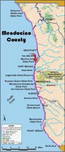
Legend: For details on the icons and trail colors, please click the legend icon on the map above.

Layers: Other layers are available. See the California Coastal Commission and Coastal Conservancy Completed Sections layer for the official completed trail segments. (About progress on the trail completion project.)
Mendocino Section 5
Westport-Union Landing State Park Vista Point to Bruhel Point North Access
Westport-Union Landing State Park officially comprises only 60 acres in a long narrow strip west of Highway 1, but its spacious pastoral setting and rocky tide zone make it seem much larger. Paved portions of the Coastal Trail follow old Highway 1, but plan to visit during a low tide to enjoy the rich intertidal zone. CCT follows the bluffs or tidal zone of the state park and tidal beaches to the south for the section's first 3 miles. Then CCT visits Westport's fine 8-acre public access headlands and follows residential streets before the provisional route follows Highway 1 to section's end.
The settlement called Union Landing perched on the windy bluff a mile north of the vista point from 1899 until the 1920s. Lumber and other goods slid down a loading chute to waiting ships. The town of Westport has had a much longer life, although it's been rather boom and bust as well. Founded as Beall's Landing in 1864, the town began to boom in the late 1870s when it acquired its current name. Westport soon had two wharves, 380 and 610 feet long on either end of Omega Street. Its two sawmills supported 400 people and two dozen businesses before 1900, but economics then fire took their toll, and little was left by 1950.
From the north end of the vista point, follow the western edge of the pavement south for the best vistas of the rocky intertidal and offshore zones. Leave the vista point behind after ⅛ mile, passing a silver gate and continuing south along the pavement through the northern end of the state park campground.
Come to the end of the road at ⅝ mile and descend the wooden stairway to ford tiny Howard Creek, then cross the small pocket beach, the sands of which are often streaked with pink grains.
For the quickest route, climb the stairway at the south end of the beach to return to pavement and the southern part of the campground. For a more scenic route when the tide is 2.0 feet or less, instead of ascending the stairway, veer west and follow the sandy then rocky beach south around Abalone Point. The beach route is about ⅛ mile longer than the pavement, and tricky footing on slippery rocks makes it more difficult and slower.
Continue south past Abalone Point and several camp and picnic areas, coming to the park's southern end at ⅞ miles. Take the trail dropping to sandy DeHaven Creek Beach, soon coming to the little creek, an easy ford in summer, usually a wet one in winter. Just beyond 2 miles, you reach a rocky point where you can gauge whether the tide is low enough to continue. If the tide is rising and the surf comes over the tidal rocks onto the beach, turn back or detour south along Highway 1. Assuming you passed the test, the beach widens beyond the rocky point.
Walk the beach south and round a second rocky point at 2⅛ miles. The beach widens by 2¼ miles with lower cliffs on your left. Beyond 2⅜ miles, the cliffs end at broad Wages Creek Beach. Just up canyon is private Wages Creek Campground. Please don't enter the campground unless you'll be staying there.
Walk the tidal zone to the south end of the beach at 2⅝ miles where you ford Wages Creek if the tide is low enough to continue. The beach turns very narrow with a sea stack dissected by a wave tunnel on your right, then Pete's Beach offers easy walking to 2⅞ miles. Just 200 feet before the south end of the beach, the Coastal Trail veers left on a path that ascends 87 steps to the blufftop beside Highway 1. If you're day hiking and the tide is still low enough, return the way you came.
The Coastal Trail follows Highway 1 into the nearby village of Westport. Cautiously follow the highway shoulder until you see Omega Drive on the right. Take Omega to stay as close as possible to the shore. It soon veers east and ends at Highway 1 in downtown Westport opposite the Community Store at 3⅜ miles.
To follow CCT, walk the highway shoulder south for 200 feet to the new Westport Headlands access on your right. Turn right and walk the path west onto the new 8-acre public access. In 150 feet the path splits in three. Turn left (south) and follow the path across a seasonal creek. CCT, following the main path here at the fine new community open space, wanders west to overlook a dark sand beach and Westport's rock-studded shoreline.
A steep, rough path descends to the beach. CCT heads south, quickly coming to another junction. While the main fork veers left, stay to the right and follow the bluff's edge to another junction at a point at 3½ miles. Here CCT turns left and heads east to return to the highway shoulder. Before you go, consider a short side trail that heads 150 feet west onto the narrow point for the most spectacular view of Westport's steep and rugged rocky shoreline.
Walk east to reach Highway 1 before 3¾ miles, then follow the highway's right shoulder 330 feet to Pacific Avenue. Veer right onto Pacific Avenue and walk it south, then east to Highway 1 around 3⅞ miles. For now the only route south for CCT follows Highway 1, So cautiously walk the shoulder south, climbing gradually over the flank of Bell Mountain. You crest the hill just south of Bell Point at 4¼ miles. Follow the highway for ½ mile as it descends along the top of a high cliff.
From the hairpin turn around 4⅞ miles, follow the highway cautiously as it corkscrews to sea level. A dirt road on the right at 5 miles leads quickly to the beach at the mouth of Chadbourne Gulch. When you pass through here at a minus tide, you might follow an undeveloped route of CCT south along the beach. The crucial point for the low tide is the rocky point .3 mile south of the gulch. If you can get around the point, subject to wave action as well as the tide, you must ascend a steep bluff to reach to Bruhel Point.
Until that route is improved, CCT continues along the highway, ascending from Chadbourne Gulch and following the steep bluffs south to 5⅞ miles and Milepost 74.6, where this section ends at a broad dirt turnout west of the highway.
ALTERNATE ROUTE: If the tide is in and you cannot get around the points at 2 or 2⅝ miles, you must follow the highway shoulder south.
SUGGESTED ROUND TRIPS & LOOPS: The pleasant walk south from the Access Point along the tideline or the bluffs makes an easy day hike. Following the tideline south from 2 miles at medium to low tide offers a rich tidal area and secluded beaches. The new 8-acre Westport Village Headlands Access offers a short but pleasant walk. Chadbourne Beach offers a pleasant walk at medium to low tide.
Distance: 5⅞ miles (9.5 kilometers).
Open to: Hikers. Bicyclists on roads, wheelchairs on most of first I⅞ miles.
Surface: Road shoulder, beach, trail, highway shoulder.
Access point: Vista Point at north end of Westport-Union Landing State Beach.
How to get there: On Highway 1 1.8 miles north of Westport and 17 miles nort of Fort Bragg, turn west into vista point and park at the north end of the lot.
Other access: Pete's Beach on west side of Highway at Milepost 77.78, Westport Headlands in town, or anywhere south along highway.
Difficulty: Easy
Elevation gain/loss: 520 feet+/400 feet-. To Westport Store: 160 feet+/ 1 20 feet-.
Cautions: Beach south of DeHaven Creek is passable only at a tide of 2.0 feet or lower.
Further information: Mendocino Area State Parks (707)937-5804.
Facilities:
Campgrounds: Westport-Union Landing State Beach offers primitive camping year round. Wages Creek Campground (private) offers showers, flush toilets and more sheltered camping.
Lodging: Howard Creek Ranch is near start of section. Several in Westport area.
Points of Interest

In the News
Interested in contributing to this project?
Register to add new photos and information, update existing results and share your trip reports.