Mendocino County
With the third longest county coastline in California, Mendocino County offers some of the greatest existing trail mileage along the California Coastal Trail as well as some of the biggest challenges for the trail's completion. Of Mendocino County's 131-mile shore, about 52 miles, or 40 percent of it, can only be followed along Highway 1, a shocking amount of highway walking in a county renowned for one of the most beautiful and pristine coastlines in the state. When you consider that another 26 miles, or 20 percent, of Mendocino's CCT can be followed only along secondary roads, the paltry 50 miles of actual trail that CCT follows along the Mendocino coast clearly falls far short of the ideal.
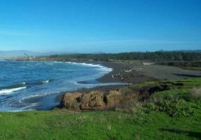
The good news is that Mendocino County's portion of the Coastal Trail features an awe-inspiring 17 to 25-mile backpack through the rugged Sinkyone Wilderness State Park. This southern half of the Lost Coast presents one of the most dramatic coastal landscapes on earth. Other wonderful portions of CT in Mendocino include the extensive dunes, beaches, forests and headlands of MacKerricher State Park, the wonderfully diverse and convoluted shore of Jughandle State Reserve, recently saved Point Cabrillo Preserve, expansive Manchester State Park, unique Schooner Gulch/Bowling Ball Beach, and the dramatic juxtaposition of historic town and jutting headlands at Mendocino itself. Even those portions of the CCT route that follow Highway l, especially between the Navarro River and Manchester, offer some of the most breathtaking coastal views imaginable.
Nevertheless, Mendocino County calls out for and deserves SO much more coastal preservation. If you walk the road miles of the Coastal Trail route through the county, you would be shocked at the miles of open and undeveloped shoreline just crying out to be saved. These areas include but are not limited to the wild coast from Usal Road south to Cape Vizcaino the southern end of the Lost Coast including Rockport Beach, the broad coastal shelf between Bruhel Point and Abalobadiah Creek, and the dramatic bluffs, coves and promontories of the shoreline from Albion south to Manchester.
In the four years since we published our first edition, some important improvements in public lands along the Mendocino coast have occurred, while others are pending. In a major breakthrough for the Coastal Trail, the Caspar Headlands have now been preserved for public access, becoming state park lands after Caspar residents organized to acquire 142 acres of their community for the public when most of their town's lands came up for sale. That acquisition provides: short but dramatic new headlands route overlooking the old doghole port at Caspar Cove. In the tiny north coast town of Westport, a chunk of the remaining undeveloped headlands have become a public space, providing another short but scenic off-highway route for CCT. The biggest public acquisition on the Mendocino coast in years was completed in March 2002 after the Mendocino Land Trust teamed with federal and state agencies, nonprofit groups, and individuals to acquire 7334 acres of former timber land at Big River, including one of the largest estuaries on the west coast. Although the new state park at Big River won't change the CCT route there, it's gratifying to look up river from Big River bridge and know most everything in sight has been preserved for the public.
Pending acquisitions include the 1865-acre Stornetta Ranch astride Point Arena and an adjacent 500-acre parcel that could both be added to Manchester State Park, and a possible state park acquisition at Albion that would provide a wonderful link for the Coastal Trail there. Even with all these new acquisitions, much work remains to be done to complete Mendocino County's Coastal Trail.
Explore the Trail
Click a section to discover more detailed information on pieces of the trail that can be explored within a day. Find highlights of what each area has to offer as well as other resources.
Usage Notes

Legend: For details on the icons and trail colors, please click the legend icon on the map above.

Layers: Other layers are available. See the California Coastal Commission and Coastal Conservancy Completed Sections layer for the official completed trail segments. (About progress on the trail completion project.)


